
I was greeted this morning by a rare-ish vertical rainbow.
Several days ago, based on wind forecasts, I thought today
was going to be about riding the Quad-B on the Quitaque Canyon section of the Caprock
Trailway, but last night’s NOAA forecast, the only thing I could get down here
in the South Prong Canyon, said otherwise.
Around here, (North Texas) especially this time of year, it’s not so
much rain or shine that dictates outdoor activities as it is the wind, and the
forecast for today had changed, calling for 20 to 30 MPH winds out of the south
and southwest, which would put them right in my teeth on the outbound leg of my
planned bike-ride. Having done that once before, I wasn’t too keen for a repeat
performance.
For now it looks like Wednesday will be blessed with
bike-ride-conducive 6 to 10 MPH winds, but this is Monday, so what do I do with
it?
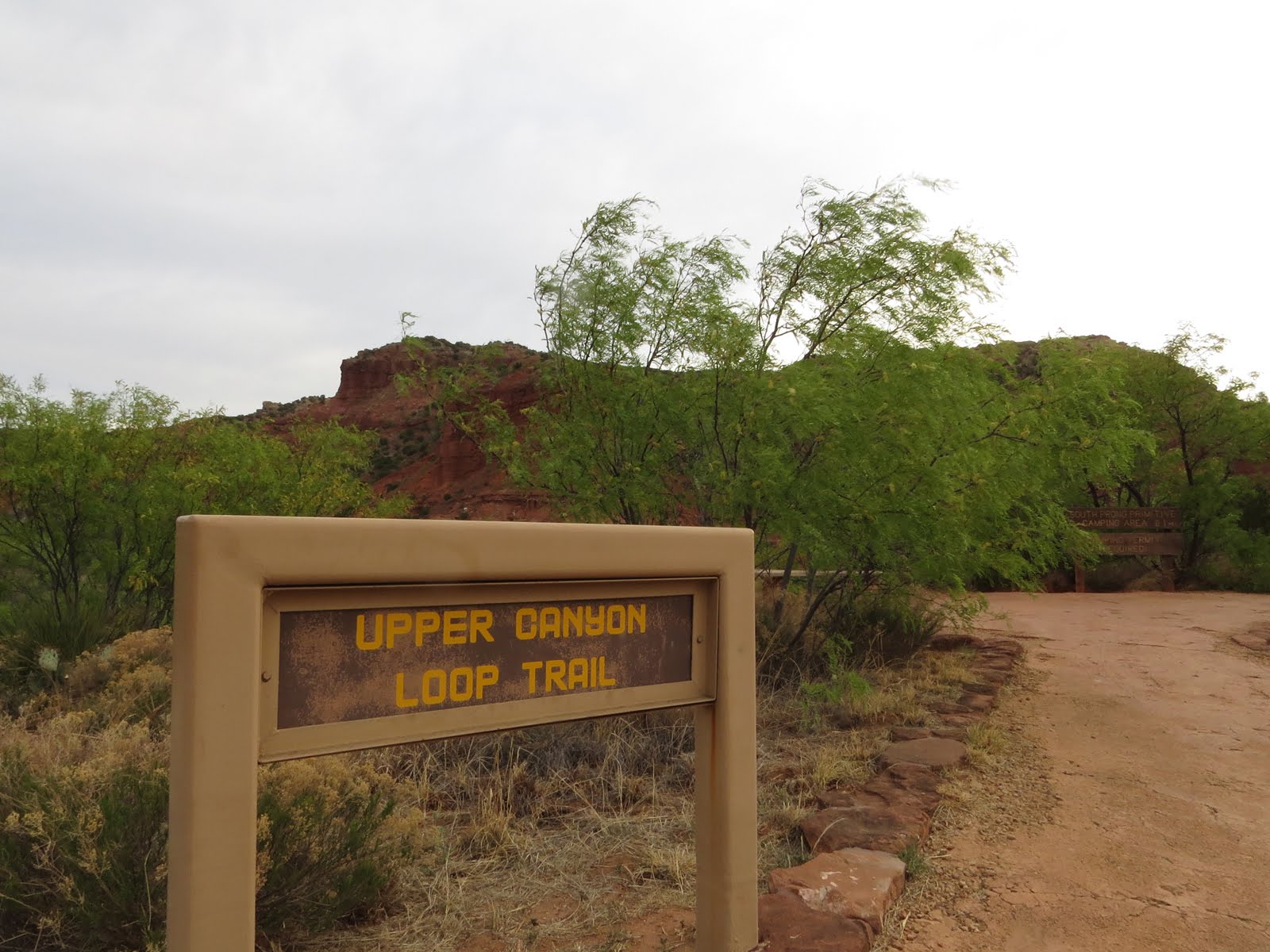
No problem, one of the Upper Canyon Trail trailheads is only
a few hundred feet from site 49 where I’m parked, but first I drive up to the
other trailhead of this non-loop trail and stash the Quad-B in the weeds so I
don’t have to hike that last mile, even if it is a short mile, back to The Van
on foot. (though there was a significant amount of hoofin' the Quad–B up the couple of hills in between anyway because by then my legs didn’t have a whole lot of pedaling oomph left
in them. . .)

Part of the reason for the lack of leg-oomph at the end of
the hike is that there are three sections of trail in the park marked as extremely
steep and rugged, and I will manage to hit all three on this one hike. (What is Wrong
with me?!)
It might appear that I numbered these three sections of
trail randomly rather than progressively, but I actually numbered them in ascending
order of how difficult I perceived each section to be. If I were the one marking up this map I
would call section 1 'steep and a bit rugged', section 2 'extremely steep and
rugged', and section 3 'oh-you-have-got-to-be-kidding-me'.

But the first part of the hike is up the South Prong Canyon
which only climbs a couple hundred feet over the next two miles as it tracks
along, across, and up the South Prong Little Red River, which is mostly
dry-wash but still travels through some interesting, and clearly water-warn, terrain.
 |
| OK, which is the actual trail? |
There are a few spots where you just might wander off the
trail and start hiking the wash instead, but no big deal since the canyon walls
will keep you confined to the general area anyway.

It was early enough when I set out that this guy didn’t want
to relinquish his last few minutes of morning-feed to some two-legged
interloper.
I was happy enough to wait, but apparently he is a shy feeder
because he soon slipped off into the scrub.

As I got further up the canyon there were a few places where
the wash wasn’t quite so dry because the underlying rock forced the water to the
surface, but only temporarily.

About a mile and a half up the canyon there’s a short spur
trail that leads up to a bench that sits safely above any flash floods. This is
where the South Prong Primitive Camping Area sits.

I suppose as primitive camping areas go it’s OK,

but it’s really nothing more than a large patch of bare
ground with a pit-toilet off to one side. At least at Pedernales Falls, South
Llano, and Colorado Bend, the primitive sites are somewhat more vegetated and separated
a bit from each other.
But no big deal since I’m not planning on staying here
anyway. (The vast majority of Primitive Site campers only stay one night. I don’t
know, after going to the trouble of packing all my gear in I think I’d want at
least two nights to make it worthwhile.)

Now that I’ve checked out the primitive camping area, you
know, in case some day I feel an overwhelming urge to revisit my younger
backpacking days, it’s back to the canyon floor and up the trail, which has
gotten downright bucolic now that there are no wheeled vehicles driving on it in order to get in and maintain the primitive camping area, which is supposed to be a
pack-it-out place but you know people. . . at least half of us seem to be genetically incapable of carrying our own trash.

The thing about bucolic places around here is that the Bison
think so too, and for such large creatures they sure can be ghost-like in the
brush, popping into sight at just the right moment to make one pee his pants.

Just over two miles up the canyon from the trailhead it, and
the South Prong Little Red River, slips through the western park boundary onto private
property.

At this point the trail makes a hard right, even though there’s nothing but looming canyon walls to both the right and left.

At this point the trail makes a hard right, even though there’s nothing but looming canyon walls to both the right and left.

The good news is that Bison will probably not be climbing
this trail, which consists of a network of loose and flaky rock all hell-bent
on getting down to the canyon floor the fastest way possible without caring what, or who, it takes with it.
 |
| Yep, that’s the trail! And to make it even more interesting the ledge is only wide enough for one foot and you have to be less than 5' tall to fit upright under the overhang |
The bad news is that if the Bison didn’t empty you of pee
down in the canyon, this trail just might do it for you now.
Basically if you don’t have at least 6 articulated limbs, all
equipped with a combination of claws and suction-devices, this trail will soon have
you whimpering and making all sorts of impossible promises to any deity you can
think of, and if you have any leftover time in between all that you will use it to seriously question the thought
process that got you up here in the first place. (At least if you are anything like me. . .)

About two-thirds of the way up I paused to look longingly
back down the canyon towards where The Van was sitting, all safe and comfy, and discovered that the climb is so steep I could still
see where the canyon-floor trail turned into the cliff-trail.
And way down there below my feet I could see a couple
standing at that transitional point. They were looking up, probably at me, and
having a discussion. I couldn’t hear what they were saying but I suspect I was
not coming out looking too good in that conversation in which terms like crazy
and damn fool probably played a big part.
Eventually the couple turned around and started back down the canyon the
other way.
Who’s the smart one now?!
(hint – I’m pretty sure it’s not me. . .)
By the way, these were the only people I saw all day.
 |
| The Van is there at the bottom-most point of my track, Fern Cave is at the end of the spur in the top-left |
After leaving the
canyon floor I climbed a little over 500 feet in the next half-mile. This
section is more of a scramble than a trail and it was often difficult to discern
the tumbled rocks of the trail from the tumbled rocks of – well, crumbling cliff-side.
Apparently I’m not the only one having difficulty picking out one perilous
route from another because there were plenty of trail-markers along this
section, though I often had to look way up over my head to see the next one,
which made me feel like my pack was dragging me backwards off the cliff, which would
trigger yet another rest-break as I recovered, during which I would forget
where the next trail marker is so would have to look again. . .
But eventually I did make it to the top, to the high-point
of the hike. This put me at the west end of the Haynes Ridge Trail which I
tried to hike in November of 2016 but the wind blew me off and I stuck to the
canyon floor instead, making an out and back hike through North Prong Canyon.
With only about half as much wind today as the first time I thought about hiking the Haynes Ridge Trail I decided to abandon the Upper Canyon Trail, which drops down the other side of the ridge into the
North Prong Canyon, just barely showing at the top of the map, and hike Haynes
Ridge instead.
But first, since I was so close and it’s not like it’s easy
to get here so I shouldn’t waste the opportunity, I temporarily dropped down the side (the
steep part labeled ‘1’) to visit Fern Cave,

which isn’t a cave at all, but rather a perpetually wet
grotto

tucked up under the edge of the escarpment where ferns have
taken advantage of the moisture and protection. (Only morning sun in here)
 |
| Track profile. Always best seen after the fact and not before. . . |
Of course now that I’ve hiked down to Fern Cave I have to
hike back up again, but frankly, despite being marked as extreemly steep and rugged,
I didn’t think this part of the trail was too bad. Or did it just seem that way
because I had so recently climbed section 3, which I have personally named Haynes' Booger?

Once back up on top again I started hiking east down Haynes
Ridge, trying to enjoy myself but haunted by the knowledge that the only way
off this thing was one of those ‘extremely steep and rugged’ trail sections.
The
last thing I expected as I trudged along was fencing.
Fencing is expensive stuff, so it means livestock, probably goats given the type of fencing,
and the only way to get livestock up here is on a far gentler trail than I just
climbed. Maybe there’s a better way down from here!! If nothing else it was a
good excuse to take another break while I sat down with both paper and downloaded PDF maps of the area to figure out where that holy-grail of a gentler trail might be.
Turns out there is an easier way, or at least used to be an
easier way, to get onto Haynes Ridge, via a track coming off the high ground of
the South Plains to the west and onto the very western end of Haynes ridge, but
that didn’t do me a damn bit of good because that’s private property over
there.
 |
| These reminded me of old-fashioned street-lamps |
So now my choice was either climb back down the cliff I just
came up, or go to the east end of Haynes Ridge where it abruptly ends, and
climb down the cliff there. Frankly they both scared the crap out of me a little, but I
knew what was behind me so chose that which I didn’t know up there ahead of me.

In reality hiking Haynes Ridge was not too bad, as long as I
didn’t dwell on the fact that I had to get back down from here at some point.
The trail, about as gentle as it was down in the bottom of the canyon only now I'm going downhill so even better, is not
overly used but not hard to follow either.
Good thing too

because I’m not sure how much longer these old wooden trail
markers are going to hold up to the harsh environment up here.

At the east end of Haynes ridge there’s an official Scenic
Overlook consisting of a single rustic log bench tucked under the branches of a scrawny Mesquite where it takes advantage of a scrap of shade but not the views. For the views you have to go stand on the edge.
Now normally scenic overlooks are the site of ohh’s and ahh’s,
maybe the occasional ‘oh wow!’ along with the frequent shutter-click of cameras, but as
I looked out across the lower canyon area with its distance tracery of the two prongs
of the Little Red River, all I could think was

‘oh shit! I’ve got to
get down there from here!’
 |
| Hard to tell in the harsh mid-day lighting, but there’s a 4’ drop from my toes to the next part of the trail here, which was about as bad as this trail ever got. Piece of cake! (OK, so it was a hard-ass fruit cake, but still cake.) |
Looking back at my track profile, it looks like the descent
down this end of the ridge, though slightly shorter with only a 450 foot drop but doing it in 4 tenths of a mile, is actually steeper than where I climbed up at the
other end, and I can believe it since this end of the ridge just seems to stop
rather than taper off, but though there are some rough spots,
 |
| My personal name for this piece of trail at the east end of Haynes Ridge is Haynes' Ass |
the trail down, probably because it’s much newer than the trail up at the other end, therefore built to different standards (Yes, there are rules on how to build a trail and they have become more nanny-fied over the years) with proper switchbacks and rock-work in the bad spots, wasn’t near as terrifying as the trail up.
Even so, this was the end of my photo-taking on this hike. All
I was interested in now was getting my ass down to ground-level, fishing the
Quad-B out of the weeds and rolling on back to sanctuary of The Van.
I knew when I planned this trip for early May that I was
pushing the weather envelope in terms of temperatures, (This part of Texas,
though further north and a couple thousand feet higher, tends to run warmer
than home-base in Central Texas) but it turns out that the temps ran 10 to 15
degrees above normal all week, pushing afternoons up into the high 90’s-low 100’s.
By the time I got back to The Van I only had a couple swallows left of the three
liters of water I carry (though I hadn’t touched the liter of emergency water I
also carry) and I sure was glad that I remembered to salt my store-bought,
low-sodium trail mix before setting out this morning!
Unlike humid Central Texas, sweating in this dry air up here
goes pretty much unnoticed, but it still drains away the electrolytes pretty
fast.
Anyway, my two cents for anyone wanting to do the Haynes Ridge from end to end is to climb up the Booger and down the Ass because there were places on the Booger where I had to let the hiking-sticks dangle while I used both hands and feet to negotiation the terrain, and it's easier to do that going up than down. Also, once you top out on the Booger it's all downhill from there. If you start out at the Ass end, even after topping out it's still a climb all the way along the ridge just to get to the Booger so your legs will hardly be fresh for the difficult descent.
Anyway, my two cents for anyone wanting to do the Haynes Ridge from end to end is to climb up the Booger and down the Ass because there were places on the Booger where I had to let the hiking-sticks dangle while I used both hands and feet to negotiation the terrain, and it's easier to do that going up than down. Also, once you top out on the Booger it's all downhill from there. If you start out at the Ass end, even after topping out it's still a climb all the way along the ridge just to get to the Booger so your legs will hardly be fresh for the difficult descent.
I never made it up the cliffs. I was already too decrepit by the time I was there. Thank you for the wonderful coverage of the hikes.
ReplyDeleteI'm too old for those cliffs too. I'm just too dumb to know it.
Delete