Monday, February 24, 2020

Camping in Chiricahua National Monument


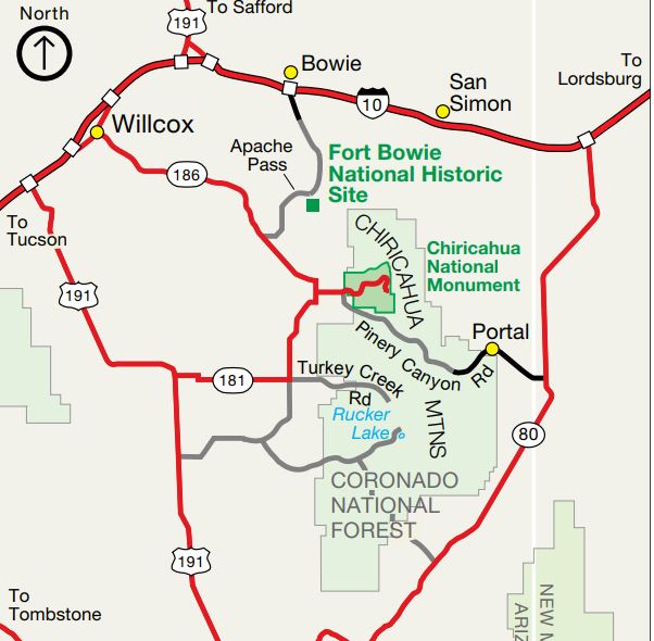
After getting blown out of Apache Pass like a hapless tumbleweed that couldn't find a fence to latch onto, I headed on towards my next destination, the Bonita Canyon Campground in the Chiricahua National Monument.


With the campground being in a wooded canyon I had hopes that the wind would not be as much of an issue there, but I was taking a chance in trusting that I could drive up blind and nab one of the 100% reservable sites at this 24 site campground.

Last night I had gone onto reserve.gov while at the rest area and found that site 22 was available for the next two nights, but then discovered that somewhere along the way my account had gotten screwed up and the system wouldn't let me log in to actually reserve the site.

There is a get-out-of-jail-free-card button that will send a link via e-mail allowing you to reset your password so I clicked. . . And waited. . . And waited. . . And waited.

It took over two hours for the e-mail to be sent to me - and then when I attempted to reset my password with the provided link - several times - it told me there was an error and I would have to try again later.  A second 2 hour wait for a fresh link yielded the same results. . . and by now it was way past dark and getting too damn cold in The Van to stay up any longer, so I gave up and climbed under the covers for the rest of the night.


Oh well, If the Bonita Canyon Campground is full I can go around the corner to the adjacent Coronado National Forest where the MVUM (Motor Vehicle Usage Map) shows that dispersed camping is allowed (those little grey dots on either side of the road) along Pinery Canyon Road, also known as FR 42.

Generally speaking, the Forest Service road numbering convention is that two-number roads can be handled by most vehicles other than low-slung sporty jobs and those too big for the averagely skilled person to be driving anyway, three-number roads are OK for average sized high-clearance vehicles, and four-number roads are getting iffy and may be limited to 4X4's.

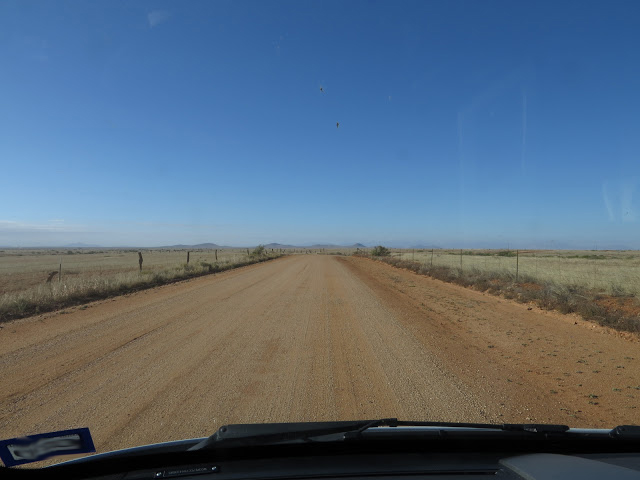
Of course this is highly dependent how long ago it rained (The fact that FR 42 is drawn as a double-line road means that only street-legal vehicles are allowed on it, not that it is paved, which it's not.) and how long it's been since a grader was run down the road. In the case of Pinery Canyon Road, I drove the first 8 or so miles of it a few days later and it was no problem as far as clearance and van-size goes, but it had the worst washboard I ran across on this entire trip, keeping my speed down below 10 MPH. And no, going faster, at least up to 45 MPH, after which I chickened out, did not smooth things out at all, in fact quite the contrary.


But for now I was trusting in blind luck that the Bonita Canyon Campground site would still be available by the time I got to the visitor center.

___

Followup on the reserve.gov account:

I never was able to reset my password while on this trip, nor create a fresh account since one with that email address already existed. I still have no idea what broke the account in the first place but turns out that the reset problem was Chrome. Something about Chrome broke the reset-password process, but once I got back home and had access to Explorer, and, incidentally, no longer needed to make a reservation,  the reset worked like it should.

I have no idea what tangled up the account in the first place but it let me "reset" my password right back to what it was originally, and then log in properly from the Chrome on my phone. I guess it's that dot-gov bit that screwed things up.

I am backed into this site about as far as I can get and as you can see, it is only a single vehicle wide. The pickup to the left is parked in site 20 in front of a 25' travel trailer, one of only a handful of sites large enough for this. 

Fortunately for me, the site I had my eye on was still available when I got there, but I could only take it for one night because the system will not let the visitor center go beyond that one night without a reservation but I couldn't make a reser - well - you get the idea. . .

In the morning I would have to go back to the visitor center again to see if I would be allowed stay another night. Beyond that I knew the site was definitely reserved. (I was able to stay the two nights.)

At $10 the cost was the highest I paid for a campsite on this trip. Would have been $20 without my geezer pass.


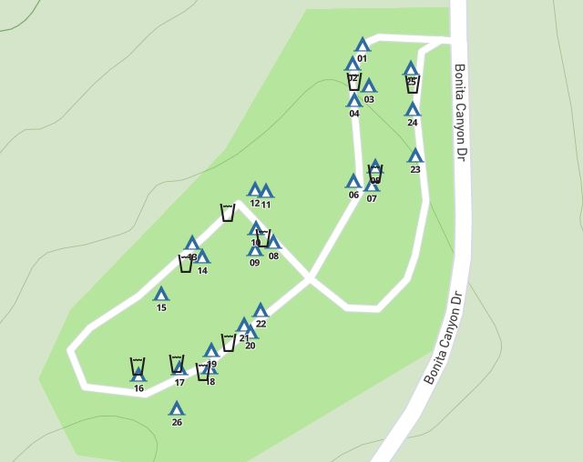
This is a typical National Park/National Forest campground in that the sites are small. In fact no rigs over 29 actual feet in length are allowed in the campground. This is in part because there is quite an abrupt dip through a wash where the two loops meet and judging by the drag marks in the pavement at the low points, even shorter rigs bottom out in here.


But also because the site sizes are limited. So when making a reservation check the site description, especially the Driveway Length, carefully.

The one above is for site 20 which , at 41 feet long, is long enough for a modest motorhome/toad or travel trailer/tow vehicle combo.


But this is the description for site 22, my site, and you can see that it is only 20 feet long, with a stove-sized bolder blocking any further progress, so don't try to get in here with any sort of motorhome other than a van-conversion and forget the trailer/tow vehicle!

I have no idea what it means when it says that Equipment is Mandatory, but this was noted on every site I checked.

And notice that Driveway Grade: Slight?  That's what it said for every site, but some were more slight than others. I did do a walk through and decided that I could use any site in there without bothering with leveling blocks, but then again I have more tolerance for being off-level than many, especially those with absorption fridges and balance issues.

There is a bathroom with flush toilets right there where the figure-8 of the campground road crosses itself, though no showers.

No hookups either, nor a dump-station, but plentiful water spigots for filling jugs. And if you are tent-camping, each site has a steel food-vault on it because - well - it really sucks when a bear shreds your tent to get at the cheese-puffs!


For those with small to modest rigs that are set up for a few days of dry-camping this campground, tucked here in the wooded bottom of the canyon, might just be the ticket to a pleasant little interlude somewhat off the beaten path.

Of course the Bonita Canyon Campground has one other key attribute.

Access to the Chiricahua National Monument trails!

The geology here, being volcanic in nature, is quite different than at Guadalupe Mountains and since it's still early enough in the day, and the clouds have cleared up nicely, and the wind isn't at all bad down here in the canyon, I'm off for a hike to take a closer look.


Monday, February 17, 2020

The Wind in Apache Pass blew out my Pilot Light!


After my cold and windy night at the Stein Rest Area I fired up The Van and headed a short distance down the road to Bowie Arizona.

Actually I was headed for Apache Pass Road, but that's one of those you-can't-get-there-from-here situations.

With no exit off of I-10 for Apache Pass Road the only way to get to where I wanted to go was to get off I-10 at either exit 366 or exit 362, one end or the other of business I-10, and drive into the heart of tiny Bowie to pick up Apache Pass Road so I could take it south, crossing back under I-10 on the way.

Home of Dwayne's World Famous Brisket Jerky, and the only fuel in town.

Be aware, if you are using an app or even Google Maps to find fuel in Bowie it may still be listing the PJ Travel Center at the east end of business I-10. If you are expecting to fuel up there and buy a few guilty snacks (Who? Me?!) you are in for a disappointment as the place is shuttered up and abandoned now.

The only fuel that I could find in town is at the other end of the business loop, and on the apps it is listed only as the Mountain View RV Park with no mention of fuel, although Google Maps lists it as Dwayne's Fresh Jerky, and there is a billboard on I-10 when approaching from the east claiming "great jerky at Dwayne's Fresh Jerky, home of the world famous brisket jerky" as well as Penni's incredible pecan pie, and, more importantly for me, hinting that this is also a Shell station.

Fuel wasn't a dire need yet since I can go 400 miles on a tank without shoving the needle down into sweaty palm territory and was only 220 miles from my last fuel stop, but I didn't know the area I was heading into so the prudent thing to do would be to top up.

But I found no sign, literally, indicating this was Dwayne's let alone a fuel station. The only clue is a couple abandoned looking pumps, one gas the other diesel, (The screen on the road side of the diesel pump wasn't working so I had to swing around to the store-side instead.) out in front of a small building sitting in front of the typical parking-lot-ish RV park. But yep. Despite the lack of any sign other than for the RV park, this is Dwayne's.

Unfortunately for Dwayne and Penni, but good(?) for my waistline, (AKA the equator) I fueled up at the pump and never went inside to check out the world famous jerky nor the incredible pies, even though I like both. (Oooo, aren't I just so goody-goody-two-shoes today?!)


Fueled up I back-tracked a few blocks to the heart of town, hung a right, went past the National Pecan Plant just before ducking under I-10, and headed south into the desert on Apache Pass Road.

First I quickly left town behind, then almost as quickly put the pecan and pistachio orchards in the rear-view as I headed on down towards the pass between the Dos Cabezas mountains on my right and the north end of the Chiricahua (Cheery cow a) Mountains there in front of me.

It was early and last-night's front was still parked, heavily, over the area, but out there on the horizon was a hint of blue-sky. Question is, is that blue running away from me or will it let me catch up?

Apache Pass Road is initially paved, though the low-water crossing dips are abrupt and unless you want to pull a General Lee (From Dukes of Hazard? - Alright! Yeah, I'm old.)  proceeding at a grandmotherly pace is recommended. The speed limit is 40 but even that will test the seatbelt on some of the amusement-park-ride-like crossings.


Most of Apache Pass Road is gravel and as I left the end of the short paved section and angled into the pass on gravel I was either driving out from under the front or it was dissipating right over top of me. Either way, I was starting to get a welcome charge out of the solar panel.


The whole point to this little excursion was the Fort Bowie National Historical Site up there in Apache Pass.


Though only about a lane and a half wide here as it works its way up into the pass, the actual pass-crossing part of the well-maintained road is only about 3.5 miles long and the climb/decent a relatively mild 700 feet, so just about any vehicle - with a running engine that is because I sure ain't pushing you up the pass! - can make it up here.


"Here" is a wide spot in the road with parking on one side and a pit-toilet, picnic shelter, info-plaques, and a trailhead on the other.


This place is a little different from most National Historic Sites in that it requires a mile and a half hike, rated as easy to moderate, from the parking area to actually reach the visitor center and the ruins of the fort. (There is a back way to drive in to the visitor center, but it's only for the mobility challenged.)

If you are here at the trailhead by 1000 (10 AM) two or three days of the week a park ranger will be here to lead you on a guided tour of the fort that ultimately ends up at the visitor center. (You are on your own coming back)

This wasn't one of those days, (Check the calendar on the web site for the guided-tour days.) but I was going to make the hike anyway.

The operative word is was. . .

I parked, climbed out of The Van, stepped out of it's high-sided shelter, the wind slammed into me, and I skidded across the gravel for several feet desperately trying not to turn into a kite.

Did I mention it was a cold wind? In case not, it was a damned cold wind! While it sucked away my heat and sent it tumbling back on down the pass I just came up I snugged up my jacket with one hand, tightened my grip on the camera with the other, leaned into the wind and bulled my way across the road to check out the info at the trailhead.

By the time I did that, looked down to where the trail crossed the wash below and disappeared behind what seemed like a very distant ridge, and snapped a few photos, the persistent and bitter wind had blown my internal pilot light out with a contemptuous little puff.

Having been raised in Michigan, playing outside all winter, shoveling the driveway during storms, building snow-forts, and yes, even tent camping in the snow, I should be ashamed, but standing there with icy drafts slicing through my innards, clawing at my rapidly retreating man-parts, and the fingers of my camera-hand already gone numb inside my gloves, I made an executive decision somewhat along the lines of "Oh to hell with this! It'll still be here next time." and clamored back into The Van, cranked the heat up high,


and finished the drive over the pass and out the other side - checking periodically to make sure my man-parts hadn't been permanently frosted and were slowly slinking back to their normal position.

Once in more open land on the west side of the pass the road widened, unnecessarily given the complete lack of traffic I encountered, as I made my solitary way the remaining 8 miles to SR-186.

I had a backup plan and was now on my way to either the 24 site Bonita Campground in the Chiricahua National Monument, or, failing that, (Last night I discovered a problem with my reserve.gov account that I hadn't been able to resolve, but more on that in the next post.) I'd head up nearby Pinery Canyon Road and find a dispersed campsite in the Coronado National Forest part of the Chiricahua Mountains.


Re-reading this I'm pretty sure I had more to say about today's adventure up there in the pass, but I guess the wind blew it away. . .


Monday, February 10, 2020

Gettin the Heck Outa Dodge, I mean the Guadalupe Mountains


Normally I don't travel on the first or last day of a holiday for obvious reasons, but on Monday Nov 11, the actual Veteran's Day of Veteran's Day weekend, I made an exception.


I packed up my crap and got the hell out of town.


Guadalupe Mountain's National Park is covered by the Midland/Odessa district of NOAA
and even has it's own dedicated NOAA broadcast tower at Pine Springs as shown by the miniature tower there on the left side of the image above.

(Pine Springs used to be a small community there across the highway from the current visitor center but now is used as staff housing and maintenance area for the park.)


This is a remote tower that broadcasts on 162.525 mHZ.

Either they don't broadcast continuously or there were several blackout periods while I was there when all I could get was static, but the evening of the 10th they were on the air and the news wasn't great.


You see that 61 degree high on Monday the 11th?  Well that was pretty early in the day with the forecast calling for falling temps, rising winds, and possible precipitation as the day went on.

With forecast lows well below the freezing point it wasn't hard to figure out what some of that percipitation might end up being, and for an ex-Michigander the picture wasn't pretty.

On top of that, winds up here in the mountains don't play around. They are of the knock-you-off-your-feet and don't-travel-in-high-profile-vehicles variety.

I had already been using the chin-strap on my hat all day Sunday to keep it withing the same zip code, and finally had to give up and move inside in the late afternoon when the wind blew my camp-chair over - with me in it. . . And this was before the winds got "strong"!


With the forecast calling for that kind of weather for two days running I wouldn't be doing any hiking up there in the mountains anyway and huddling inside The Van somehow just didn't appeal.

So I fired up The Van first thing and by mid-morning of the 11th I was at the Walmart at the corner of US-62 and loop 375 in El Paso stocking up on fuel and salad-fixins.

El Paso has always been a pain to navigate through because of congested traffic trying to squeeze through the narrow gap between the end of the Franklin Mountains and the border, and with the recent growth that has only gotten worse, so it's great news that after what seems like a decade of construction, they have pretty much completed loop 375, (There's still some ramp work going on in a few places.) allowing me to swing around the northeast side of town with a minimum of traffic hassles.

At the northern end of the loop I could continue straight ahead and cross the Franklin Mountains via the Woodrow Bean Transmountain Drive. I've been over this 1300' climb right through Frankling Mountain State Park several times in the past, but as I approached I could see a steady stream of trucks and other traffic out there above me working their way up and over I so hung a right on 54 instead, followed a mile later with a left onto FM-3255.

For a few miles this route, heading due north away from the city, is flanked by expanding neighborhoods, most of which don't show on my 2013 map, but these soon fall away and by the time I crossed into New Mexico where the road changed name to NM-213 I was back in the desert.

Not much more than a mile into New Mexico there's a roundabout at the intersection of SR-404 which I wrapped myself 3/4's of the way around to head west on 404.

I still have to climb up through a pass, or maybe it's a nostril since it's between the peaks of Anthony's Nose and North Anthony's Nose, when crossing 404 to pick up I-10, but this pass is a gradual climb/decent of only a couple hundred feet, suitable for the most underpowered of the mega-RV's.


This is the Rockhound State Park day-use area and the trailhead for a couple of trails up into the Florida Mountains.

It wasn't in my original plans, and, though the weather wasn't all bad at the moment, listening to NOAA, now the station out of El Paso, I knew that blast of cold and wind was somewhere back there behind me doing it's damnedest to chase me down, but as I approached Deming, NM I got a sudden wild hair anyway and took a 16 mile detour to check out Rockhound State Park.

I've stayed at several NM state parks ranging from the far north to the far south of the state and for the most part have found them reasonably nice places to camp,

This was one of the only empty campsites but I couldn't find the marker to see if it was reserved (red tag showing) or available. (green tag showing)

but I can't say I was terribly impressed by Rockhound which is tucked up there under the western flank of Florida Mountains. And since the visitor center was still closed, even though it was well after the lunch-hour, I couldn't find anyone around to help change my impression.

So I backtracked those 16 miles and continued on my way.


My route across New Mexico has been paralleled by a busy line of the Union Pacific railroad and my destination for the day, now that I've bypassed the State Park, is the Stein rest area just across the border into Arizona. (After living in Texas for 37 years I find it strange to be able to drive clear across a state in a matter of hours instead of days.)


As rest areas go, with minimal separation from the highway and virtually none from the truck-parking, this one would get a passing-grade-but-nothing-spectacular-to-write-home-about, if it weren't for the fact that the Union Pacific tracks snake by just over the back fence.


And the eastbound trains coming up the grade out of San Simon are usually powered by two or three engines on the front,


two more in the middle, and a final engine on the rear,


all working hard as they pound their way up and over the pass just south of Stein's Mountain back there across the New Mexico line on their way to Lordsburg and points east.

The draft-gear, the couplers, that connect the cars together, are rated for about 350,000 pounds of pull and if all the engines were lined up together at the front there would be broken couplers littering the landscape. So instead the engines are spaced out along the train (This is officially called distributed power.) all of them controlled by a single crew sitting in the first engine.

The westbound trains, heading downhill but not yet fast enough to call too seriously on the dynamic brakes, which whine pretty loudly when worked hard, drift by almost silently, which is cool too!


And there are a lot of trains passing here!


Think of these tracks as the steel version of the Panama Canal.


To avoid the costs of transiting the canal, many container-ships offload at the ports of southern California, have the containers shipped to Houston or ports further east via rail, and loaded back on other ships to continue their journey. (It works the other way, east to west, too)


But even though these railcars are kept busy, sometimes they sit long enough to pick up some rather elaborate and well-done graffiti.


Though it was pretty late in the day by the time I arrived at the rest area, I, train-nerd that I am, still gave my camera one hell of a workout as train after train went by,


and think I have shown remarkable restraint here in severely limiting the number of posted photos.

(Yep, patting my own back, because who else will do it?)

Oh, and that weather that was supposed to be chasing along behind me?

I was beginning to wonder about that too as the evening slipped into night with balmy temperatures and very little wind.

But if you go back and look at the rest-area trees in some of the photos, notice all the leaves on them?

Well the weather did finally arrive and by morning, after rocking me somewhat persistently through the night (This seems to bother some RV'ers and I see jacks fully deployed even for overnight stops in an attempt to limit the rocking, but I don't mind.) while I slept under blanket, then blanket and sleeping-bag, and eventually scull-cap too, as the temps dropped precipitously, and by morning most of those leaves had been stripped from the trees and piled in drifts along the curbs, against the building, and behind the fence-posts.


Monday, February 3, 2020

Shoving my Nose up the Crack of Bear Canyon


Whoo-Hoo!!!

Soon it will be light enough to hit the trail!

OK. To some, those that like their sun high before oozing out from under the covers, preferably to the smell of fresh-brewed coffee, that may seem slightly perverted, but - well - I'm up and ready!

Ready for what?

Well. . . Despite all the logic and good-sense involved, when I back down from a goal it often leaves a bad taste behind, an uneasiness stirring around in my head. And from the safety of camp, from the comfort of my chair where it's impossible to stop rethinking my decision, it often manifests itself as a sense of regret that pops it's ugly head up at the most inopportune times, like when I'm trying to pat myself on the back for the things I did accomplish.

So what am I ready for this morning?

Let's call it a little redemption. But responsible redemption. (Which I know I'm going to regret - the responsible part - later, but what can I do??)


Yesterday when I slinked back down off the mountain in disgrace from my aborted loop-hike through The Bowl, a Park Service LEO was waiting at the trailhead, leaning her imposing height back against her patrol vehicle with ankles casually crossed closely watching each and every returning hiker (She was there to nab some damn fool that was letting his rather large and loud dog run around off-leash up on the Peak Trail which was scaring the crap out of other hikers. That earned him a ticket that he wasn't at all happy about, which doesn't bode well for the likelihood of him changing his behavior and following the rules in the future.) and I asked her if she was familiar with the Bear Canyon Trail.

She was, and confirmed that it is indeed steep, especially at the upper end, and going up that trail is probably a smarter move than coming down it. (OK, she may have been placating me, but it helped take some of the sting out of my retreat.)

While I'm feeling great this morning I'm not sure it's the best of ideas for me to attempt the full loop-hike all over again today, (Yep! Responsibility, or at least the excuse of responsibility, is already putting the brakes on the day's activities.) the other way around this time, but my curiosity has been tweaked so I'm just going to poke my nose up the crack of Bear Canyon from the lower end and get a closer look at it.


After about three quarters of a mile of hiking, despite the flat light of an overcast day that makes it difficult to pick out distant details, I can see the location of the canyon there in the fold between the ridges.


 At the mile and a half mark I come to the base of Bear Canyon Trail for the second time in a handful of days, only this time I turn up instead of to the side.


Yes, I've been here before, but now I'm going up instead of past, so with this new perspective I zoom the camera in to take a closer look.

Holy Moly! No matter which way you shake the box, when the pieces fall out that's a long way up in  a big hurry!


Trying to find solace in the knowledge that this was purely an exploratory probe, I pushed the trepidation threatening another early-abort down to somewhere near my belly button and moved-feet.

I had just barely started my way up the canyon when I came across this convenient bench carved from the remains of a fire-ravaged tree.

And yes, I took advantage of it. I mean someone put a lot of work into this so it would be disrespectful not to take advantage of it!


But the trail, even when it's scary, at least in the imagination, is a demanding mistress (Aren't they all?! - Demanding that is.You know, mistress')


and I was soon quickly gaining elevation.

Enough elevation to get one quick glimpse of the Frijole Ranch before my view was blocked by the shoulder of the ridge forming the north wall of Bear Canyon.


But my attention was soon diverted by this odd, almost man-made looking feature on the opposite wall of the canyon.

I'm sure somebody can explain how it came to be, but not me.

You'd think something like this would be named, but if it is I couldn't find any reference to it. So I decided, given that this is Bear Canyon and that looks a lot like the picture-window in the front of every ranch-house on the street where I grew up, to name it El Ventana del Oso. (Sounds classier than Bear's Window) Not that anyone listens to me. . .


Anyway - over on my side of the canyon - the trail continues to climb while the end of the canyon refuses to get any closer.


But I keep at it and it isn't long before I'm starting to get into some of that fall color again.


Distracted by the color, and nervously preoccupied enchanted by the mist drifting around in the upper reaches of the canyon like some nebulous being of the heights just daring me to venture into it's domain, it took me a while to notice the pipe snaking up the opposite side of the canyon.

See it there just over halfway up the right side of the photo?

And yes, that's a stacked-rock wall above the pipe.

Initially I thought that wall might be the remains of some sort of road or track that had something to do with installing and maintaining the pipe, and maybe it was at one point, but now it's supporting a 2' wide section of the trail.

If you look a little below the pipe you might be able to spot a bit more trail on which, after I give up some of the elevation I've managed to gain at no small effort on my part and cross over the wash in the bottom of the canyon, I will backtrack down-canyon a bit then switchback to get up to that built-up section of trail.


On my way there I get a closer view of the pipe.


A pipe that continued to snake it's way alongside the trail and far up into the canyon.

Can you imagine the effort it took to drag a 20' length of pipe, after 20' length of pipe, after 20' length of pipe up the rugged canyon, having to climb farther and higher with each section?


And this is no wimp of a pipe either!

Based on the 1" length of the first joint of my index finger, this is 3", heavy-walled schedule 80 iron pipe that weighs in at somewhere around 10 pounds per foot, or 200 pounds per 20' length.

Remember a few posts ago when I was waxing nostalgic about how, if circumstances had been a little different, I might have grown up on the Frijole Ranch?  Well maybe not so much waxing if this was one of the projects in those days. . .


Anyway, the trail


like the pipe


kept on going up


and up


and up.


I know just how she feels up there with a permanent crick in her neck from trying to see the top of the canyon!


I climbed until I reached about this point.


Where I had covered about 2.5 miles horizontally and climbed 1300 feet. Nearly the equivalent of 2000 steps up a fire-escape over 100 stories high.

Not all that bad actually. An average climb of 520 feet per mile. Not any worse than climbing the Tejas trail yesterday.

But even so, I'm only at slightly less than 7000' up so there's still about 1000' to climb before I get to the same level as the rim of The Bowl - which is less than a half mile away.

In other words, the remainder of the climb is about 4 times steeper than what I've been doing so far. . .


At this point, since today was always about taking a look and not about making the whole loop, (No! Honest! I didn't wimp-out because turning around was always the plan! . . . At least that's what I keep telling myself. . .) I felt justified in making an executive decision to call lunch.

And after the repast I'm going to turn around and head back down the canyon leaving that final push up the rest of Bear Canyon for another trip.

Of course for all of us, and more so for those of us that are getting on up there in years, there's no guarantee of "another trip", but then again, I am Irish, and there is an old Irish toast I like that says: "May you die before you run out of dreams."

In other words, though my bucket-list is very changeable, my plan has never been to completely empty it before I'm dead lest when I do so I - well - curl up and die.


In the meantime - not a bad view while I munch my tuna and crackers. . .


Which apparently, based on the fact that he kept hanging around, this guy wanted me to share.

I didn't - share that is.

(I have, with a bit of research, now identified this guy as one of a group of beetles known as buprestid, or jewel beetles. If you grow fruit trees you do NOT want to see this guy since their larvae bore through wood.)