Monday, November 28, 2022

Not For The Squeamish

 No, seriously, if you are squeamish about squishy things or the reality of survival, stop reading now, close this post without going past the first photo and just leave it alone.


I have walked thousands of miles, maybe getting on up into double digits of thousands of miles, of trails, and over the past 20 years, a thousand or few more miles on the trails around the property.

During those miles I have stumbled across a lot of things that go on in the natural world, including a fresh, as in still warm and steamy, eviscerated moose-kill in Alaska while hiking back to the trailhead (It wasn't there on my outbound trip just a few hours earlier.) that scared the crap out of me because I didn't know where the bear (The distinctive tracks were clearly evident) it belonged to was.

But after all these years and all those miles, I still haven't seen everything.

Just the other morning as I came along the trail across the bottom of the largest ridge on the property, unable to see the barn on the other side of the pond because of the fog which made things slightly spooky anyway,


I was stopped in my tracks by this.

No, I didn't stop quite as close as this. It's just that after I got my phone out and swiped it alive I put my foot in the frame for scale.

Based on the the size and a couple of tufts of fur scattered around the perimeter I'm guessing this was a rabbit.


I've come across kills and carcasses on a quite a few of my treks, but never one quite like this.

In fact this one is the complete reverse of the norm.

Normally one of the first parts of a kill gone after by pretty much any predator is the belly because it's a soft entry-point. And usually, because of the high nutritional value-to-effort ratio, the first parts consumed are the organs. Including, actually especially, the stomach and intestines which contain highly concentrated nutritional value that is easily digested.

Why this stomach and intestines were left laying there when the rest of the animal was missing (Yes, I looked for it) I have no idea, and given that in all my years wandering unleashed in nature this is the first time I've ever seen anything like this other than at a human hunting camp I don't expect that I'll ever see it again.

Yes, perhaps a little cringe-worthy, but an intriguing mystery and a fascinating anatomy lesson. I've seen all sorts of drawings of stomachs. Everything from cartoonish Pepto adds to anatomical pictorials, but I have never seen the real thing laid out so clearly before!

OK, so I'm actually a little squeemish myself, but I love learning new stuff! 

Monday, November 14, 2022

I Spent a Week There One Afternoon!

 I'm not opposed to hiking the same trail over again - and again - and again. After all, the light is rarely the same from hike to hike and I always seems to find something new to see along the way.

In fact, to illustrate my point, when doing my laps around the property just this morning, (Nov 9) laps I have done literally thousands of times over the past 20 years, I came across something in the middle of one of the trails that I have never seen before, anywhere! (I'll probably get around to posting about it sometime, but it won't be for the squeamish!)

Besides, a bad day out in the open on a trail is way better than a good day on the couch, 

But I have been in a bit of a rut lately where I'm feeling a little burned out on my usual camping and hiking haunts.


So I went poking around in the wrinkles of my maps and found this new-to-me place.

Martin Creek Lake State Park over in the East Texas Piney Woods

At 286 acres not an especially large State Park, but it does have some trails, so I figured what the hell, let's give it a shot.

All I've got to lose is a couple mortgage payments worth of fuel, which we can spare since we put mortgages behind us long ago, and a week's worth of time.


Having never been there I hadn't had a chance to compile my usual list of best-OK-bad campsites, so when it came time to reserve my site I sat down with the campground map and rolled the dice, hoping I didn't come up craps!

People seem to find lakeside sites attractive, but to me they are often exposed, busy, and noisy (Boy wasn't that the truth in this case! - something I'll get to in a moment) inside-loop sites back up to other inside loop sites and also tend to be a little closer to the neighbors on either side than outside sites, if there's a choice I give 50 amp sites (the green ones in this case) a wide berth because the 50's attract larger rigs which tend to have multiple air-conditioners, outdoor entertainment systems droning and flickering on well into the evening, hugely annoying fairy lights blazing brightly all night long, roaring water-heaters trying to keep up with long showers or loads of laundry, and yappy lap-dogs, and those sites close to bath-houses and dump stations - well, need I say more through the din of idling engines and overly tired kids screaming around the feet of parents desperately trying to avoid getting tangled in the dump-hose and splashing used bathwater and shit all over themselves, or the constant slamming of the bath house door?

So based on the fact that it is an outside-loop site away from the lake shore and 50 amp-ers, a long ways from the dump station, just about as far from the bath-house as I could get, seemed to have just a little extra gap between it and the adjacent sites, - and it was available - I blindly picked site 44.


 Which turned out to be a damn good toss of the dice.

As advertised, it is set a little apart from the sites on either side, in fact separated from one by a steep gully and both by untamed brush and woods, backed up to thick woods behind that shielded the site from the lake, and with a nice light and sound damping woods buffer in the center of the loop between me and the 50 amp-ers on the far side.

My own little private corner for the week, albeit one with little solar potential!

Yep, still loving my 200 AH's of BattleBorn lithium ion batteries.

Being September in Texas it wasn't exactly cool, (That doesn't happen until well into October and then for only a few tantalizing days at a time.) which makes my compressor-fridge, my largest battery consumer by far, work hard at sucking electrons, but I arrived on a Sunday afternoon with a full charge from about 6 hours of driving the nice open, sunny roads, never plugged in, and my batteries still had enough charge left to carry me for one and a half to two more days as I rolled back out onto the sun-drenched roadways the following Friday.


In addition to campsites, including primitives over on the island, which is reachable by a foot-bridge,


this park also has screened in shelters with bare concrete floors for camping without the flapping fabric and snarl of tent poles,


"cottages" with adjacent water-points, a couple of iron beds, and even air-conditioning,


and if that's still a little too much like roughing it for you, there's  a couple of ADA accessible, two bedroom, kitchen and bath with running water, cabins.


But I'm only interested in the camping.

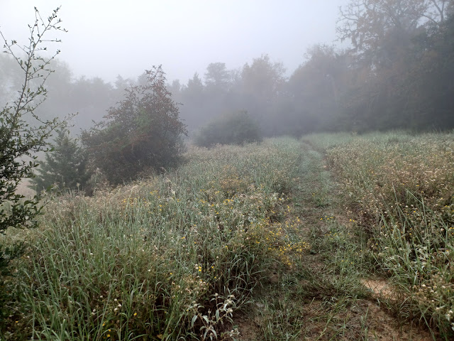
So once I got set up, which consists of parking, popping the canopy up, and unfolding the camp-chair, I used the remainder of the afternoon to go on my ritual first-time-here campground-stroll intending to compile my best-OK-bad list of campsites for future reference, (If I take a horizontal photo of a campsite number post it's a best, if I don't take a photo it's an OK, if I take a vertical photo it's a bad) but I ended up putting the camera away because in the context of this campground I was already in the best site and (other than the caveat coming up in a moment) there were no particularly bad sites. For instance, site 73 here is an inside loop site, but as you can see there is a solid buffer of trees and brush between it and site 80, another inside loop site on the opposite side.

So what's this "issue" I've hinted at a couple times?


Yeah - well - I suppose the line between hum and roar is subjective.

For the most part the trees around my site did a pretty good job of knocking the noise down to a persistent but acceptable level,


but there were a few times after the sun went down that it sounded like a convoy of heavy trucks, with maybe a tank or two thrown in for good measure, was easing up the loop-road towards me.


with their lights on!

I don't know why power plant managers feel the need to burn up a fair portion of their output, a portion that we as consumers have to pay for, (Even if you live completely off-grid, the cost of electricity is embedded in the goods you buy) but every power plant I've ever seen at night is lit up this way.

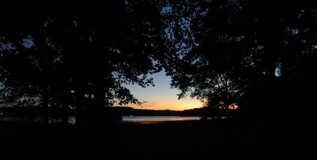
And you see that bright light in the center of the photo? (Well that was a dumb question! How could you not?) It seems to be a big-ass spotlight aimed across the lake directly at the State Park, Unless it's purely for the annoyance factor I have no idea what it's purpose is, but when I turned away from taking this photo from the lake-shore


 I could actually see the spotlight casting a shadow of my shoulders and hatted head on the tree behind me.

Now what in the blue-balled hell is the sense in that?! (No, not that kind of blue-balls. With all the stuff that's been going on in the world the past few years I'm just assuming hell has frozen over so it must be damned cold there!)

A question I'm sure the unenlightened who chose a lakeside campsite and are now trying to sleep with the undampened noise and that light shining in the bedroom window all night would like an answer to.


But it, the power plant, is a complex and busy place that, every time my hiking took me to a particular vantage-point on the island, 


provided an hour or so of voyeuristic entertainment.

But I was kinda surprised at the somewhat primitive coal-handling processes.


I guess I was expecting something more like a grain-bin type operation.

Dump the coal into a pit under the tracks, use augers, legs, and conveyors to move the coal to a storage area and more augers and conveyors to move it from there to the boilers.

Instead there are dozens of bulldozers, water-trucks and these heavy tractors, each pulling two earth scrapers, making endless loops following each other up, around, and down the pile as they constantly reshape and shift the stash of coal.

But enough of the industrial revolution. What about the hiking?


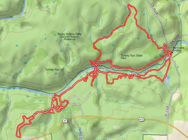
Well, as I stated before, though it has three different loop trails this park isn't all that big.

The longest loop is 1.5 miles and the shortest is 1.1 miles. AND, with the exception of a couple very short ups or downs, the terrain is as close as you can get to flat.


If I linked all three loops together into one hike and added in crossing the large day-use parking lot (I counted 87 vehicle&boat-trailer parking slots and at least that many car slots, thankfully mostly empty during the week I was there)


to get to and from the bridge to the Island Trail, it was just over 5 miles of putting foot to ground.


I'm close enough to 70 now that I can reach out and push the gate to that septuagenarian decade open so it's ready for my entry, and it's likely that at some point in my future, which is charging at me with the speed of a toddler towards an untended cookie jar, 1 to 2 mile loops will be my physical limit, but for now I'm still going strong,

so what I did was link the three loops together,

make a stop back at The Van for a civilized snack, 


then turn right around and do the trails all over again in the other direction.


Unlike the 3+ MPH pace when doing my workout laps on the property, my average hiking speed tends to hover slightly below the 1.5 MPH mark, so combined with a Spanish lesson or two, some reading, some sitting around staring into space while my mind free-flowed, (or just lay there in a puddle of healthy mindlessness.)


the 10 miles gently filled out the day right up to dinner time very nicely.


So that was my routine there at Martin Creek Lake State Park for five consecutive days. Tracing the same three loops, the only three loops, around and around, first in one direction then the other. And to add some almost unbearable drama, I would also change up the order that I hiked the loops. 


I'm not saying I was eager to leave Friday after one last familiar trail-circuit before the weekenders started packing the place like a desperate chipmunks cheeks, (There were, of course a few people in various campsites and some others fishing near the boat-launches, but I ran into absolutely nobody out on the trails all week.) but I was ready to leave.

I'm not ready however to strike this place completely off my list. It wasn't that horrible. And it could have its uses in the future. But I probably won't be coming back in what you might consider the immediate future.


Monday, November 7, 2022

Time For a Change?

 I'm a map person.

                      Always have been.


I like maps!

                  I grew up with them.

                                                The traditional folding variety


as well as the more detailed book-form atlases.

They were in the car, on the kitchen table, under my bed, and even illicitly tucked into my schoolbooks. (With the right textbook, if you hold it up at an angle you can hide more interesting reading material from the teacher!)


So I've spent many hours with maps. Sometimes finding my way - and not in the zen way - although that probably couldn't hurt.

Sometimes just paper-exploring.


Sometimes orienteering, which is something we did a lot in my Scout Troop.

And hiking, even in familiar territory, with them in my pocket just in case. A tattered old security blanket if you will.

But I'm also a mild teckie, (As opposed to a rabid teckie. The difference is that I still turn my lights on and off with a $3 wall-switch and not with an app on my cellphone and $100 dollars of added gear.)


so many years ago, long before Google Maps came about, I added electronic maps to my repertoire.

I started out using the Delorme Street Atlas for PC, and after several versions of that (The only way to get updates on Delorme's products was to buy the new version every few years, but fortunately it was surprisingly affordable,) I eventually switched 


to the Delorme Topo series.

All the useful features of Street Atlas, though still the same sort of update strategy, but also the topo feature that the hiker and off-the-beaten-pather in me could put to good use.


In addition to uploading the GPS tracks (recorded on a Delorme Earthmate PN-60 handheld) from my hikes into Delorme Topo


I also use this USB GPS puck for road navigation right on the PC


using this stand clamped between the seats, on which


I've been setting my PC up next to the driver's seat for many years now.

Counting back through the vehicles I've been using this stand in, for something like 18 years. (But this current laptop is only 12 years old!)

If I stick to one of my usual routes I don't really need the navigation help, but even then,  somehow being able to glance over and verify my position in the world on the longer trips is comforting. (More of that Zen stuff I suppose.)


And when I've wandered off onto a new route, something I'm prone to do, the split screen of the navigation mode, the right side a closeup view for picking out turns, (I can zoom in several times closer than this if necessary.) and the left side a longer range view that allows me to figure out where I am in the larger context of the world.

All of which is much more convenient, and safe, than the solo driver trying to use a paper map.


But - - - (Oh come on, with that title you knew there was a but coming!) - - - Garmin bought out Delorme's electronic division about 8 years ago and quickly scrapped the whole line of electronic products, all the GPS's and the whole line of digital maps - even though they had no comparable PC-based product of their own - to get rid of the competition.

So I've been stuck with my old copy of Topo 10 ever since.

There's been a whole lot of road construction since then and because updates aren't available anymore, I often find myself driving on what my outdated map thinks is empty land on roads that aren't supposed to be there. (i.e. Grand Parkway 99 around Houston, I-69 through southern Indiana, the Hooser Heartland Highway between Lafayette and Logansport in northern Indiana, US24 across northern Ohio) 

Obviously this isn't going to get any better. And there's also the very real possibility that my laptop is going to crap out one day and force me onto an OS version that won't support my discontinued Delorme Topo. (I'm still running Windows 7 right now)


So for this year's family reunion trip I thought I might try weaning myself off my old standby, stop suckling at the teat of Delorme, and see what it's like to sit at the big-kid table with Google Maps instead.

Predictably, after 2700 miles I can say there's pro's and con's to both Delorme and Google.


Delorme

Pro
  • The split screen let's me do turn by turn navigation in one screen while keeping track of the bigger picture in the other
  • I can leave breadcrumbs along my track which makes keeping tabs of where I am and the recent turns I've made easy (Sometimes that little blue dot on Google Maps is hard to locate with half-second glances)
  • I can automatically double the width of roads and the font-size of place-names, and highway designations in navigation mode
  • I can upload my hiking GPS tracks so I can refresh my memory when going back to a previously hiked area or writing a post about a particular hike

Con
  • The whole PC setup is bulky and intrusive
  • The map is not update-able with new roads
  • The old screen is fading with age making the map difficult to see under some lighting conditions
  • The USB port the GPS plugs into is old and worn and sometimes drops connection, which means I do without until next time I stop and can slap things back to life

Google Maps

Pro
  • Very compact compared to the laptop
  • Roads are updated frequently
  • Real-time (almost)  traffic conditions
  • Displays estimated arrival time making it easier to plan my day or give The Wife a heads-up on when I'll be rolling in the driveway (She hates for me to arrive unannounced!)
  • Can easily switch on the fly to a weather app to check on conditions out ahead of me
  • In "directions" mode, even with the volume turned off to shut the lady up, (Just because she's there doesn't mean I have to listen to her all the time.) it displays how far to the next turn and which way I'll be turning.
Con
  • Can't double the font-size or displayed width of roads making information and lesser roads difficult to see at a glance.
  • Must "pinch" to zoom the screen out for a wider perspective then tap the "re-center" button to get auto-tracking (keeping my current location in the middle of the screen as I move along) working again, which also automatically zooms the screen back in whether that's what I want or not.
  • All roads, regardless of type, are displayed with the same grey line
  • No topo information


Notice that I didn't say much one way or the other about the relative size of the 15" laptop screen verses the phone screen.

That's because even though the phone is quite a bit smaller I can negate that by mounting it closer to my eyes, something that's not practical with the laptop.

So the results of my weaning experiment?

Google Map worked for me - for the most part. There are bits of things I'll have to adjust to, some things I'll have to do without, other things I'll have to get used to, but it was easier to make the switch than I expected.


And let's just say it has been a relief to finally take that bulky laptop stand, that for year's I've tucked awkwardly away upside-down into the passenger-seat footwell when not using it, out of The Van and store it away on a shelf in the barn!

From now on I'll be navigating with Google Maps on my phone, 


though the laptop with TOPO 10 will still be coming along because it still does some things better.

Such as giving me the ability to stick pins into the Delorme map.

And I have a lot of pins in my map!


Some of them are places I've found and/or been to that I want to remember


Others are places other people have wrote or told me about that I might want to go to one day.


Another key use of my laptop is photo editing, though I'm not sure what I'll do when the laptop craps out and the free copy of Photoshop that came with my very first digital camera isn't supported on the new OS.

But when that time comes I'm sure I'll figure it out


A few more comments about the nav-tools:

With the Delorme, other than briefly using it to get an estimated drive-time before setting out, I never set up routes to drive by. In part because there are often roads available that Delorme didn't know about and also because the route function isn't self-healing when I go off-route to explore some new bit of road, which I'm prone to do. But with Google Maps I find the distance-to-next-turn when in "directions" mode helpful when on an unfamiliar route and Google Maps self-corrects when I wander away from the suggested route, so I've been using the routing feature.

When Using Goggle Maps in "directions" mode with the volume turned up  the lady-in-the-box is pleasant enough, but maybe too pleasant. When I turn away from the suggested route or don't turn when she tells me to, she gently bongs at me and calmly gives me new directions in the same, even voice. I kinda wish there were a couple of additional 'frustration' levels I could choose from. Maybe one that says 'Hey! Wake up! I told you to turn back there." and another that's more like "HEY DUMMY, WHATS THE MATTER WITH YOU!? YOU JUST MISSED THE FRIGGIN TURN! - AGAIN!)

I kinda wish I could trade her out for the little girl I recently saw in a short video. She was a tiny little thing, not quite old enough to form her words very clearly, sitting on the lawn in a tiny chair as she explained that this was the ice bucket challenge and giving the names of those she was nominating. At this point she says "lookout" and an adult hand appears from the side holding a pan of water, no ice but obviously cold, and gently pours the water over the girl's head. This sweet little pig-tailed thing dressed in pink squeals, jumps out of the chair, and exclaims "FUCKING HELL!"

I'll bet she could keep me on my toes!

I also kinda wish I could teach Google Maps my personal driving style. (Something I can do on Delorme) When plotting routes Google Maps apparently uses the full published speed limits with no downtime, no rest stops, to estimate the time between here and there. In my case, since I drive no more than 65 even when the speed-limit is 70 or 75, or in the case of Texas, 80 and 85, and, like a real boy, I do make the occasional stop along the way, Goggle consistently underestimates how long it will take me to get to there.

But that's just niting picks.


So, in addition to reading books, (Kindle app) reading magazines (Sidebooks app) streaming TV shows, (Amazon Prime) backup to my handheld GPS, (Gaia GPS app) shopping, banking, paying bills, daily Spanish lessons, working brain puzzles, keeping up with Blogger, email, and texts, researching stuff, finding overnight parking spots, making campground reservations, checking on the weather, making written notes, recording thoughts, timing how long the fish has been on the grill, reminding me when it's time to side-dress the vegetable plants with fertilizer or send a birthday card, Blue-Toothing to my solar charge controller or the dash-cams, Oh! and making phone calls, (Although my average monthly talk time is something like 23 minutes - and no, we don't have a landline.) pretty much anywhere and anytime, now my $300 phone with $50 unlimited data/text/talk plan is also my nav-system!