Monday, August 31, 2020

The West Trail; Too Ambitious for an Old Fart?


Snaking through the hollows and over the ridges of Lost Maples are a number of trails, and over my 5 day stay I managed to hike all of them. And without killing myself!


The bulk of the trails,the East (green) and West (blue) are laid out in a couple of loops that share a central spine (purple).

My first day here I jumped in with both feet - so to speak - and tackled the West Trail. I even threw in the West Loop (yellow) in for good  measure.  (Umm, was it really good, or just egotistical foolishness?)


From my campsite, down there in the lower-left corner, most everything about this park is uphill, until it's downhill. (Yeah, I know, that statement is about as nonsensically necessary as telling someone I'm standing right in front of that I'm here. But really, it sounded better in my head than it looks on paper, and since I've already written it, it stays. . .)

For this hike the initial climb is along along the gradual tilt of Can Creek, then up the steep scramble to the ridge circled by the West Loop Trail. Of course now I had to get back down off that ridge by a different, but equally scrambly route, only to, after a short reprieve along the lower reaches of Mystic Canyon, where the trail gets sketchy at times as it shares the limited space with Mystic Creek, head sharply uphill again to the ridge near Primitive Camp E, and finally back down until I stumbled wearily back into camp.


 But first, back to the beginning.

By the time I got to the joint trailhead this morning I had already hiked the better part of a mile to get from the campground, past the maintenance area, across the Sabinal River and finally to the Overflow Parking area that doubles as trailhead parking near where Can Creek flows into the river.


Not far from the trailhead, if you look very closely at the cliffs to the southwest


you just might spot this. A Redtail Hawk nest precariously tucked well out of the reach of predators.

Like Eagles, Redtails mate for life and also nest every year in the same spot, adding to the nest each season. This being late winter there was no nesting activity going on today.


Next stop was the point where the two legs of the West trail split up (or come back together depending on where in the hike you are). Today I took the branch to the right and will return on the branch to the left.

And if that straight line over to the right in the photo looks suspiciously like a curb, you're right.

Just across the other side of Can Creek you can make out a two-track climbing back up out of the creek. Prior to the mid 1970's this was a working ranch and under that arrow, on a bench above the creek,


sits what used to be the ranch-house and some outbuildings. Today it's used as the Park Superintendent's house.


After hiking along Can Creek for a bit the East Trail peels off and goes its own way right about were the Pools are located. These, the pools, are only one mile from the trailhead parking and are a very popular spot.

So popular that much of area along the accessible north side of the pools, to the right in the photo, is roped off right now to allow it to rest and restore itself. Primitive Camp C used to be here but I kinda doubt that it will ever be reopened again, even after the area has recovered.

Fishing is a popular activity here (In Texas you don't need a license to bank-fish if you are standing on State Park land.) but the Sabinal River and Can Creek are one of the last refuges of the highly endangered Guadalupe Bass so all fishing is catch and release only.


Eventually I made it beyond the pools to where the West Loop Trail leaves (and returns to) the West Trail.

The temptation to skip adding this additional 2.5 miles to my hike was strong, but I resisted the lure of common-sense (not as difficult as I, and especially my mother, would sometimes hope) and forged on anyway.


In the past this elaborate concrete-filled steel pipe anchored one end of a fence-crossing over the upper reaches of Can Creek. That fence marked a boundary between two ranches, and later between the State Park and a ranch.

In 2009 the State bought that 600 acres on the other side and added it to the park,


 though they haven't yet gotten around to updating the signs, nor have they added a new trail through the area. Admittedly, it is a bit rugged up in there. (giving into temptation, a few years ago I did a little bushwacking back in there.)


This fence, however, along the west side of the West Loop, does mark a current park boundary, and the mid-point of my perhaps ill-advised little side excursion. It also meant I was nearing the location of primitive camp H. Which meant lunch break!


As I was hiking up Mystic Canyon after coming back down off the West Loop Trail I found this laying on the ground.

To some this might look like nothing more than a bit of Spanish Moss gone astray, but to a modelrailroader the foliage possibilities are downright titillating!  But, like National Parks, everything here in a State Park is protected, so I put it back where I found it and walked away, though there might have been a longing backwards glance or two. . .


As I was coming down off the ridge where Primitive Camp E sits I came across this trail marker.

Seeing as how that's a  nearly vertical 25 foot rock wall back there behind the marker I'm not entirely sure it's necessary - - -


I eventually closed the loop and ended up back at the trailhead parking area.

Since I still had the better part of a mile to go before I would get back to The Van I used the excuse of the adjacent bird blind and this cabin to linger here for a bit.


Since there is nothing on the web-site history page, and no informative info-plaque to be found, I have to assume that this was once used by the ranch foreman or some other worker(s).

These blocks the walls are made of are larger than bricks but smaller than cinder-blocks, so I poked around a bit


and found this spot where a gas pipe, a later addition, had been crammed through the wall. Now I could see that these blocks are made of clay, like bricks, but are hollow like cinder-blocks. When I was wandering around Venezuela back in the '80's-90's these were a very common building material but not one I've seen much of here in the US.

I sure wish they'd post more of the historical info for those of us that are curious about that stuff. . .

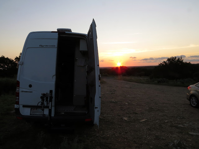
But for now, I've already hiked nearly 9 miles, burning up a healthy chunk of the day at my usual snail's pace, and still have some hiking left to go before I get back to The Van and can finally put a nice big dinner into action. (After all, no sense in risking burning off too much of this hard-earned fat!)


Monday, August 24, 2020

Lost (Maples) in Texas


Texas has some place-names that are a little out there, like a Looneyville, a Jot 'Em Down, a Needmore, and a Bug Tussle.  But then Texas is a big place so there's plenty of room for oddities like Nimrod, Cheapside, and Ding Dong.

And with all that space it's no surprise a few things got lost. There's even a couple websites like LostTexasRoads and Lost-Texas that are trying to un-lost lost Texas stuff.

Apparently there's also a few lost trees wandering around the state, like the lost pines that, instead of hanging out around East Texas with the rest of their brethren, can be found huddling together, scared and traumatized by the Bastrop County Complex Fire but still there, near the fringes of the Hill Country in the Bastrop State Park, and the lost maples setting up homestead in the hollows of the Sabinal River in - well, Lost Maples State Natural Area.


Which is where I am now. ( This trip was actually taken in late February 2020, just before coronatine shut everything down)

This photo was taken on my last trip here in late fall some six years ago.

As you might imagine, during fall color season this park, despite being somewhat remote, is highly popular. In fact, it's not at all unusual for the park to reach it's capacity of 250 day-use vehicles by mid morning and start turning arrivals away.

You could always plan your trip for a couple weeks after peak season, as I did back in 2014, and still get some decent color without the hoards, but if you insist on peak color, and can abide the crowds, the State Park system now has a "Save The Day Pass" that can hold a spot open for you. These can be purchased up to 30 days prior to your trip, but remember, you will be competing with all the other people that want to visit at the same time and, reservation or not, the number of passes is limited by the number of parking places. (You can make campsite reservations up to 6 months prior, but expect the same rush on sites during peak color)

View of the park's maintenance facilities tucked into the valley alongside the Sabinal River. The campground is out of sight around the corner to the left.

Now I enjoy peak color season as much as the next guy, but not enough to willingly put up with the crowds,

Yep, the outside temp was 27 this morning and overnight a healthy layer of frost had built up on the inside, between the window-covers and the windshield.

so a crisp trip in February was, once you factor in the crowd-cringe element, easily as enjoyable.


Don't get me wrong, it seems that there is rarely a time when this park is empty. (Well, except maybe for that Christmas day back in 1983 when a freeze and ice-storm locked most the state down and we had the place to ourselves, not even a ranger around to take our entry fee.)

Many of these rigs in here were just over-nighters, which I find a little surprising since it's not like this place is on the way to anywhere,


but even mid-week the 30 water/electric sites were about 60% full every night I was there, and don't count on driving in without a reservation on a weekend, even in the off-season, and finding a place unless you are headed for one of the underutilized back-country hike-in sites.


Anytime you get more than a few people together there's probably going to be some numbnuts among them, such as these people in a motorhome that cost more than our house who insisted on leaving the "hey, look at me, aren't I cool" under-chassis lights on all night, (Which, if we are brutally honest about it, are really "please look at me because I'm so insecure I can't stand not being paid attention to" lights) completely ignoring the fact that


this park, located at the cross-hairs in the map above, normally sits just out of reach of the star-gaze killing glow of San Antonio and Austin at a refreshing 3 on the Bortle Dark-Sky Scale, (The bright greys at the city centers are a 9 on the Bortle Scale) has a dark-sky designation.


To stay here on a generously sized water/electric site (Unlike some parks in the system, there are no less expensive hook-up free drive-in sites at this park, besides, my house batteries are definitely past their "use-by date" so I didn't mind running the fridge off the park's electric.) with sheltered table, and a shower with flush toilets, costs $20 per night (Plus $6 per day per person entry without a Park Pass)

Oh yeah, don't count on a cell signal here, even from the ridge-tops. Several years ago I had to drive 60 miles round-trip to check in on The Wife who, though she claimed she was getting better, was pretty sick when I left the house.


Of course the main draw here, at least for me, is the 20 some miles of trails, which I'll touch on a little in the next few posts.


Monday, August 17, 2020

Is Comfort Overrated? Or is it Underappreciated?


So, regarding the advisability of going on my latest camping trip.

This was as I was preparing to set out on a mid-day hike the first day I got to Colorado Bend State Park.


Was I comfortable camping with no hookups during the hottest month of a Central Texas summer where afternoon temps hit triple-digits with humidity up in the uncomfortable range, and morning temps are still high and the air even thicker?

Oh hell no!

But then again I'm not an idiot so I didn't expect to be comfortable. (Here's the point where some of you out there are thinking "Oh yeah, he's an idiot!")

So why did I do it?

Well first, it's hiking and camping. Duh!

This was just before sunrise the next day


But another reason is that, in my opinion anyway, many of us spend far too much time bowing before the throne of comfort.

It's an evolutionary thing, the drive to seek out comfort. After all, the guy (And I'm using the northeastern "youse guys" here which covers all sexes.) that seeks the comfort of a warm cave is more likely to survive, at least to breeding age where this trait can then be passed on, than the guy who walks face-first into the blizzard while laughing.

Evolution has served us hominoids well for about 2 million years, getting us through challenging times when branches of the family, (actually scientifically classified as the superfamily of Hominidae) those that didn't go extinct anyway, are estimated to have numbered as little as a few hundred during the worst of times.

But frankly some of those evolutionary traits haven't been doing us homo-sapiens any favors for the last 20,000 years. Things like  a propensity to violence, (The guy with the biggest stick and a willingness to use it survives.) bigotry (The guy that fears those that look different or don't share the same beliefs is more likely to survive than the guy that walks up to strangers with open arms - see propensity to violence -) and greed. (The guy with the most stuff is more likely to survive the winter.)

Like all evolutionary traits, the desire to seek out comfort is hard to shut off on short notice, (Our latest, "civilized" 20,000 years is about 1% of our 2 million years of evolution, so yeah, that's short notice.) and today, with technology and economic circumstances making comfort so readily attainable for many of us, that's not necessarily a good thing.

This has resulted in people that are literally incapable of functioning outside the "comfort zone" long enough to carry on a two-sentence conversation before having to stumble, completely debilitated, back into the AC in order to function.

I think a good part of this is because they have suckled at the teat of comfort for so long their zone of tolerance, that area either side of comfortable in which they can still function effectively, has shrunk away to nothing. I've seen first-hand how life-limiting this can be and would prefer to avoid it myself.

After all, unless you occasionally gnaw on over-cooked flank-steak you can't truly appreciate the exquisiteness of  a perfectly prepared filet mignon. If you haven't frozen your toes for hours in the slush of an early spring you'll miss out on the true joy of a hot drink warming your insides while a hot fire toasts the outside. Unless you spend time sweltering in triple-digits you'll miss out on the orgasmic quality of a rain-cooled 85 degree breeze.

Too much of most anything, including comfort, results in over-familiarity, under-appreciation, and a flat life. A life lived close to either side of the median, well away from the painful lows, but also the exhilarating highs. And when you think about it, they don't write biographies about those that have lived flat lives.

Not that I want a biography written about me, but I do think I owe it to myself, my parents, and the rest of my ancestors that gave me this gift of life, to live a rich one that covers the full spectrum of the experience.

Bad cameramanship here as my phone is actually showing 1908 (7:08 PM)


So back to the original questions:

Is comfort overrated? Only those who have too much of it might think so.

Is comfort underappreciated? Again, only by those that have too much of it.


Monday, August 10, 2020

Gone Around the Bend - Colorado Bend that is


I briefly escaped coronatine for two half-days, a full day, and two nights at Colorado Bend State Park last week.

Given that the oppressively hot August climate around here is not that conducive to a whole lot of out-door physicality my pace was glacially slow, but I still managed to get in about 20 miles of foot-stomping, or at least foot-shuffling, but at the price of about 20 gallons of sweat, some seriously sticky clothes, and a little bit of funk.

(I tried reading Patrick Taylor's "Alone on Purpose" during this trip, the third in his trilogy, this one covering the winter, the cold, snowy winter, he spent by himself in the wilds of the Frank Church Wilderness in the mountains of Idaho - Jeremiah Johnson territory - but it didn't do much, as in diddly-squat, to cool me down.)

So why put myself through that?

Well a couple of reasons, but the big one has to do with that number circled there on my phone in the Duolingo Spanish language course.

I'm too cheap to spring for the cost of the off-line, add-free version of their course, so I have to have a data signal to complete a lesson - and see the advertisement at the end of that lesson - (My marketing daughter would be so proud!) and that circled number is my current "streak". Yep, 152 consecutive days since I was last out of cell service for more than 24 hours. And that's just sad! (But on the plus side, now my streak-count is back to zero!)

Nope, not a trail, but in this heat walking up that stream-bed flowing with cold water right from the spring so clear you can't see it sure was an attractive thought!


This park is not what you would call close to the house, so by the time I got there that first day it was well into HOT, but still too early to just head on down to my pre-reserved campsite, (The only kind allowed right now. No drive-ins permitted. Not even for day-use. Instead you have to go on-line, make your reservation, if there's a slot available, and print out your window-pass before heading out.) so I turned into the Gorman Falls trailhead instead.

Not that I had any intention of hiking down to Gorman Falls. That place is way too popular for my taste even in normal times, unless I can get there around dawn, which wasn't happening today.

But I had to share the first leg of the Gorman Falls trail to get to the start of the Gorman Spring trail which is where I was really headed.

I suppose I could have hiked the service road down to the Spring trailhead instead, bypassing whoever was on that first segment of trail, but one of the goals today was to see just what it was like to be hiking around others in these corona-times.

It wasn't horrible, only slightly worse than hiking with others in normal times. I would hike along until I heard people coming, then pull my mask up, get well off the trail, carefully since there's a lot of stickery things out here, and let them pass. (Other than the mask, and how far off the trail I went, this is my normal routine anyways.) Some wore masks in this state where it's finally mandated now that our governor was forced to pull his head out of Trump's ass by the horrendous numbers, (It's an election year after all) some did not. In both cases I just stood back for a while after they passed and let their potentially viral-laden respired droplets and vapor dissipate in the wind before continuing on until the next encounter.

I had the Gorman Spring trail to myself and when I got to the spring itself, where this pump was put into place 100 years ago to service the Lemon's Ranch on the ridge above, I was tempted to plop my ass down right there for a late lunch.

But this is the end of the trail, and its main attraction, and if someone else did come along I'd be right in the way, so I moved back down the trail to a spot where I could climb up and away from the trail on a few limestone ledges and chow-down in peace.

One other (mask wearing) person did eventually come up the trail, but only after I had finished lolly-gagging around and was headed back out anyway.

I didn't take any campground photos, but since I was unable to get my preferred slot in site 45, I had picked site 44 instead since I knew it also wasn't shaded, an important solar consideration when the fridge is running almost constantly in an attempt to stay ahead of the heat.

It's not that site 45 was taken, it's that the park is only allowing camping on even numbered sites to force a little more distancing.

The next morning my target was to make a loop out of the Spicewood Canyon & Springs trails and I was up early enough to disturb the neighbors,


which was too bad, but I was chasing the man in the moon down the river in an attempt to stay ahead

of evil Mr. Sun who was intent on running me down from behind.

Even though I didn't allow myself time to pause and worry about becoming kitty-poop

the inexorable sun caught me anyway and thus began the day-long process of it trying to burn a hole in my hat.

Oh, by the way, until this corona thing settles down I will not be packing out other people's trash, so, to all the slobs out there - CLEAN UP AFTER YOURSELVES DAMMIT!

Spicewood creek is mostly a series of pools as it steps down the limestone ledges in it's run towards the Colorado River, and as you might imagine those pools are pretty popular this time of year.

But I foolishly wasn't thinking about that in the people-free early morning when I turned right onto the canyon trail to make my usual counter-clockwise circuit.

This decision had me climbing up along that rim on the left before dropping down into the canyon below where you can just see a couple bright glimpses of the creek as it heads towards the river which is flowing from left to right just below that far ridge in the center.

Maybe that sun burned through my hat a little because choosing to turn right and head up along the ridge first put me down there on the creek later in the day when the hoards had finished their coffee, gotten the kids organized, and headed out to do some soaking in the cold water.

Note to self: Hey dummy! Next time do the loop clockwise and stay away from the herd!


After stopping by camp long enough to restock my water-bladder I slowly wandered north along the river for a few miles peep-toming some of the private residences perched over there along the eastern shore and giving my mobile paint-set a workout, because that seemed a better way to spend the rest of the afternoon than hanging around camp panting like a dog that's been chasing cars all day.


I prepped The Van the night before so that last morning I was able to slip away from camp early and move several miles up to the west end of the park, but that damn sun was relentless and there it was, waiting for me! I'd get a restraining order, but can't seem to find the proper jurisdiction to file in.

The river and bluffs, the creeks and canyons, may be sexier, but the rolling heights up here away from the river (the only place where I never ran into a single person) are the true heart of this land.

This is where the early human inhabitants harvested grains and other staples, along with the occasional  larger animal that provided meat and tools and clothing.

This is where later inhabitants harvested cedar and raised livestock, creating economies and communities where none existed before.

That horizontal mark there is actually a short piece of a trail created by thousands and thousands of ant-feet as they industriously, and constantly, move back and forth from here to there. Here was the nest. I never was able to figure out what there was.


And this was where I slowly circled on my last hike of the trip, attempting to tease the rich history of this place up out of the ground and the abandoned fence-lines.