Monday, November 25, 2019

An Easy Loop Hike in Lower Canyon, And Just In Time


If you only have time and/or ability for one moderate hike in Caprock Canyons State Park, the  2.9 mile Lower North Prong Trail, teamed up the the 2.2 mile Lower South Prong Trail and connected together at their west ends by the 1.3 mile North Prong Spur makes for a decent hike along the North and South Prongs of the Little Red River.

Note, make sure you have the 2019 version of both the paper and electronic trail maps.  Between the 2013 version and now, the trail names have been changed. On the older map this route is the Lower Canyon Trail connected on the west by the Canyon Loop Trail.

The trail designations have been changed on the new map as well. For instance, the Haynes Ridge Overlook Trail used to be designated as Trail B. On the new map it is Trail HR.

And to add to the excitement, the actual trail markers out in the field have not yet been changed over so the old B markers are what you will find along Haynes Ridge. If it helps, which doesn't seem very likely, for some reason the 2019 version of the Park Facilities map still uses the old trail names and designations. . .


Whatever you want to call them, this set of trails will take you along both the North and South Prongs of the Little Red River,


sometimes dipping down into the river bed, other times climbing up to the flats above, but always staying down in the canyon-floor


and avoiding those serious climbs up the encircling ridges. (Unless you take a detour up the Mesa Spur Trail, which is a shortcut to the Mesa Trail, to check out the view from the mesa top like I usually do.)

The Mesa Trail, a balloon trail, is designated as an easy hike, but it doesn't connect to any drive-up trailheads so getting there requires hiking the Wild Horse Trail which is designated as moderate, leaves from the equestrian camping area, and covers about 1.6 miles (One way) before you can start the 3 mile Mesa loop.


It was 38 degrees when I set out this morning so I was wearing my over-shirt (Hard to see since it's nearly the same color as my shirt), a skull-cap under my usual straw hat, and gloves.


The canyons here are all about erosion, to which this tree has nearly fallen victim.

Obviously, when it sprouted it did so on reasonably level land, but over the years that land has been washed away. (For an idea of how far above the river-bed this tree is go back up three photos and check it out.)  Fortunately by that time the tree had strong enough side-roots to hang on, but for how much longer can it last out there in mid-air?


This hike gives you plenty of chances to get up close and personal with the geology of the canyon-floor.


And because it is along the lower canyon


where it's has more time to collect, you're more likely to see surface water here than you are in the upper canyon.


The point where the Mesa Spur takes off from the Lower North Prong Trail is well marked. In fact, too well marked.

There were two markers here today, the old, laying back there on the ground in the background, and the new. Only thing is I couldn't see that there was anything wrong with the old marker at all.

The lettering and arrow were identical on both, and nearly as crisp and clear on the old as the new. The wood cross-piece and steel legs of the old were in excellent shape. The only thing missing were the caps on top of the legs.

I would have thought the money could have been better spent on putting up trail-posts with the new designations instead of replacing a sign that didn't need replacing, but then again, nobody asked me. . .


It's a bit of a scramble up the spur trail,


but the view from up here,


out across the entire canyon, makes a little bit of climbing worth it.

And being just about the halfway point of today's hike, a good spot for lunch.


It was a Thursday when I made this particular hike and my timing was fortuitous.

The trail had obviously just been flagged by something called the American Volkssport Association.

Having never heard of them before I looked them up later and found that they are a club dedicated to health through nature walks.

So, by deduction, I assumed that on Saturday this trail would be inundated by chatty AVA members.


Whew!

Dodged a bullet there, or at least a plethora of walking sticks.

But I was impressed by how they use wooden clothes-pins to put up their trail-markers.

Now, after the event is over, the flagger can come along and easily remove all trace of their presence.


Monday, November 18, 2019

Caprock Canyons: Sunrise Conversation


The downside of the really good, AKA pretty much cloudless, weather I had during my week at Caprock Canyons State Park


was a lack of spectacular sunrises.


The best I could do was to incorporate some foreground elements into my shots.


And even resort to opening The Van's sliding door and taking an interior shot of a sunrise. (Hey, it made sense at the time!)


But lack of award-winning sunrises didn't seem to hamper the conversation one morning.

It started with one or two coyotes yipping in the crisp air somewhere in the near end of the canyon, you know, as in near where I was parked.

"Yi-Yi-Yip-Whoo-Hoo! It's morning!"

The yips were quickly followed by a full-throated howl, starting low and rising up in both the register and amplitude, then held long enough to defeat the best of opera singers.

"And I guided my pack safely through the night!"

This was answered by additional yips from further up the canyon's north side, perhaps out of one of the side canyons coming down from that direction.

"Oh big deal!  We made it through the night too."

Answered by more howl.

"Well I did it better and I'm the boss over here in these parts so don't you forget it!"

Then yet a third group, this one way up in the far reaches of the south side of the canyon somewhere.

"Yeah, well we made it through the night too and we're going to hang out up here today so don't come poaching our area."

"Well that's fine by us. We'll stay down here near the mouth of the canyon where it's better anyway."

"We don't care. (chimes in that second group) We like our spot here in the box canyons on the north side. So just leave us alone."

"All right then. . ."

And things fell silent again.

Thirty seconds of morning conversation that would have been so easy to miss out on.


I know they are out there. Having seen their scat several times, all shiny and purple and peppered thickly with yellow seeds from chowing down on ripe prickly-pear pods.


Maybe have even seen their tracks. Though I'm not near enough of a tracker to distinguish between dog and coyote, especially in soft sand,


even with my handy Tom Brown's Field Guide to Nature Observation and Tracking in hand,


because the differences are subtle. Too subtle for me.

But it was a privilege to hear them.

Not my photo!


Monday, November 11, 2019

A (Mostly) Sensible Hike on the Upper South Prong Trail


Sunrise is so flattering.

It reveals the real me, all long, lanky, and skinny under this extra padding.

From now on I'm only going out in public at dawn!!


To make up for two consecutive days of questionable choices, today's hike is an easy ramble up the Upper South Prong Canyon in Caprock Canyons State Park. The campsite is just behind me and my destination is out there at the far end of the canyon.

Well actually, in the interest of a reasonably comfortable evening tonight, the far end of the canyon is not really the destination but rather the halfway point since I do intend to come back to the shelter of The Van today. . .


It's a nice day. The light is good. And there's nobody else around.  (And y'all know how I hate to be alone. . . sarcasm . . .) Can't think of a better day for a hike.


Maybe not compared to the garish pages of graphic novels or the numbing intensity of gaming screens, but the colors are passionate out here this morning.

A variety of greens slashed through with a splash of blue and back-dropped by a cornucopia of reds and oranges


then punctuated once in a while with brilliant accents,


all framed and contained by millions of years of geologic process. It all practicality commands one to stop, breathe, admire, and reflect.


Of course when I say there's nobody else around I'm referring to the bipedal, opposable-thumbed variety of nobody.

In reality there's all kinds of things out here and I'm actually the odd-man (literally if my detractors are to be believed) out.


And some of those things out there are a bit startling!


As big as they are, these dang things are like ghosts, suddenly appearing out of nowhere. Silent and graceful despite their 1200 pounds and having twice as many legs as me, the only way to know when one is nearby is if it comes out of the concealing brush and into the open so I can see it. But only if I happen to be looking. (Tip of the day: If you can smell them with your highly inefficient human nose you are too damn close! Way too damn close!))

This particular one could be part of the group of three bulls that interrupted my hike up the Eagle Point Trail last year.

Since bison, even the bulls, are not solitary creatures it's a pretty good bet there's at least one more of these guys here somewhere, lurking un-see-able in the brush just waiting to scare the crap out of me.  (That evening there were at least two of them, probably including this one, down by where the road just outside the campground crosses the river.)


Eventually we each went on our own ways, but I'm pretty sure I was still being watched by many eyes.

From dudes hunkered down in their Mexican blankets with hats pulled down low,


to ladies in hoods and long dresses stirring up some concoction in shallow cauldrons.


OK. The plan was to stay down in the bottom of the canyon, but when I hit the base of the Extremely Steep and Rugged, which should have been my turnaround point, I didn't.  At least not right away.


As that upper arm of my GPS track over on the left side shows, when I hit the wall I kept going for a bit rather than do the sensible thing, you know, like turn around. . .

The safety of The Van is a couple hundred feet below and way out there under that far mist somewhere.

I don't rightly know why I didn't turn around.

I've climbed this trail before and decided then that going up was something I could do, if I had to, but coming back down that trail would take some serious pondering. (My sole people encounter on yesterday's hike was a young couple that came up this trail but would rather go around and miles out of their way than try to go back down it again.)

But - well - we've already established that I've got a bit of the Idiot in me.

The white roughly shows the route of the "trail" (I put it in quotes because it's more of a scramble than a trail.)

But today only a bit. (Of the Idiot)

You see that dark spot the arrow is pointing to?


That's this. Which I photographed from the uphill side when I came up this trail last year and couldn't believe that I actually got around it. (But first I used up the better part of a half hour thinking this was a joke and looking for the real trail. . .)

This is a hollow carved out of the rock wall by water.

If you look carefully, the down-mountain side of the trail approaches the hollow on that barely discernible ledge about two thirds the way up on the right edge of the photo.

It doesn't show well in the photo, but just under my feet as I took this photo is a 6 foot vertical wall down to the bottom of the hollow. A featureless six foot wall.

If you are hiking up-bound with others you can drop down into the far side of this hollow, carefully since it's a long ways down if you get too far over to the right!, and then help each other up the wall on this side.

If you are hiking alone you need to negotiate that ledge that wraps around the rim of the hollow.

Only the ledge is just a few inches wide, just barely the width of a knee, and the overhang above means that unless you are really short you have to take to the ledge on your hands and knees and hope your pack doesn't get snagged on the overhang.

Anyways - You see where the ledge starts  on the far side just above the big grey boulder? (That boulder that is conveniently tilted at just the right angle to throw you off the mountain!)

Today that's where I turned around.


Oh yeah.

On the way back down to sensible I photographed this spot, after sliding down the steep chute on my butt, because it contains all three of the major rock formations that ultimately formed the canyons around here.


Back down on the canyon floor I wasn't quite ready to head back to The Van just yet, so I went off-trail and followed the wash upriver for a bit.

Not very far because the western boundary of the park is nearby, but far enough.


The walking is easy along the bed of the river, at least when it hasn't been raining, but you are never far from reminders that bison are also wandering around in here too, confined by the same walls hemming you in and severely limiting your escape-routes.


This, located near my turn-around point, would be a great little lunch-table! Now if only I had a chair with me. . .


Monday, November 4, 2019

Haynes Ridge Overlook Revisited: or Idiot Squared


After pulling the bone-headed stunt of climbing on my bike, the Quad-B, after a bike-riding hiatus of nearly half a year and covering 30 miles of noticeably tilted north-west Texas terrain on tire-dragging cinders yesterday,


this morning I groaned my abused and aching self up out of bed and headed out for a hike that included 2 of the 3 "Extremely Steep & Rugged" sections of trail within Caprock Canyon State Park.

Stupid?  Perhaps.

Idiotic?  Most likely.

But I was on a roll so why stop now?  (I know, I know, lots of reasons to stop now, but apparently I wasn't hearing them. . . Idiot!)

The numbers roughly correspond to the locations that the numbered photos that follow were taken from

The first part of the day's hike, from the trailhead parking in the bottom-right of the map above up to where I hung a hard left onto Trail B, the Haynes Ridge Overlook Trail, wasn't too bad.


I even had some high terrain off my right shoulder to shade me from much of the morning sun.

( 1 )

But then I made that hard left and was faced with the reality of that daunting wall that forms the eastern end of the Haynes Ridge.

There used to be a sign-post at this trail intersection, but now, other than the bare-dirt trail branching off towards the west, the only marker is a lonely, weathered bench placed there for those who wish to sit for a moment and reconsider their choice of trail.

I didn't. . .


Instead I marched towards that 600 foot wall and the promise of an overlook with confidence as if I knew what I was doing. OK, confidence might be overstating things slightly, but I hiked on anyway, like Columbus sailing off the edge of the world, only in reverse.


Every once in a while I would pause during that upward slog that was reminding me of yesterday's foolishness on the Quad-B with every step, and look longingly back down to where I went wrong - I mean where I made that left turn.

It seemed so far away down there. A reminder of how many careful steps up the jagged and uneven rock it had taken to get here,


but when I turned back to the climb there was always so much more of it to - well - climb. . .


But being the dumb-ass fool-hearty beast that I am, I kept on going. I kept on getting farther and farther from that fateful turn, until there couldn't possibly be any farther to go.


But there was. . .

( 2 )

Eventually my pigheadedness persistence got me to the lofty heights of the ridge, from where I could look south-southwest with longing down at The Van patiently, smartly, waiting for me there in the parking lot near the trailhead.

Which raises a question. It's common knowledge that The Van, like all modern vehicles, has more computer power in it than the Apollo capsules used to get to the moon and back. Does that mean The Van, sitting down there all snug and comfy, is smarter than me??

( 3 )

I guess I'm not smart enough to figure out the answer to that, but from a vantage point a few steps further on down the trail, I could look east, northeast down the valley of the North Prong of the Little Red River and see the faint tracing of the highly sensible Lower Canyon Trail that perhaps I should have been hiking instead.

But for now my path lay westward as I hiked the lonely length of Haynes Ridge.

Yep, out here on my own again. Well, almost. I did encounter one young couple at the west end of the ridge that were slightly confused and needed a little help getting headed in the right direction.

( 4 )
Nearing the western end of the ridge I came to the end of Trail D there at the intersection of the Trail A and Trail C segments of the Upper Canyon Trail. The Trail A segment, off to the left in the photo, where it falls off the ridge in one of those "Extremely Steep and Rugged" segments is an adventure in itself. Trail C, the northern portion of the Upper Canyon Trail, is straight ahead and will eventually U-turn into the Upper North Prong Canyon and head back east again.

For more on ascending Trail A, as well as more of a description of hiking along the Haynes Ridge check out this post from last year.

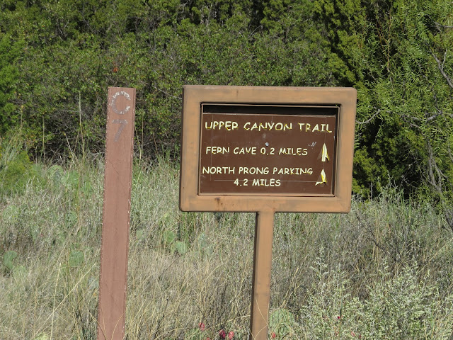
Oh, and don't get too invested in that claim that Fern Cave is only 2 tenths of a mile away.

It's more like double that and to get there I have to give up most of my hard-won altitude as I scrabble down the third of the "Extremely Steep and Rugged" trail segments. And in case you didn't know, going down is actually tougher in many ways than going up.

If you look close at the post next to the sign you can see it is marked with a "C" over a "7".

C, as we have established, is the parks designation for the northern section of the Upper Canyon Trail, the one I'm about to follow, and the 7 - well, it seems to me to be slightly weird, but C1 will be at the trailhead, in this case where the Upper Canyon and Lower Canyon trails intersect with the North Prong Spur Trail.

Roughly a half mile further along will be a post marked C2. So C1 is zero, C2 is .5 mile, and so on, making C7 3 miles. So essentially you subtract one from the number on the post and that tells you how many half-miles you've either come or have to go, depending on which direction you are headed.

( 5 )  Taken with my Canon SX50 with the lens at the equivalent of 24mm

At this point I'm nearing the north west corner of the State Park and can occasionally hear a truck making the steep climb up SR 256.

In fact, just one turn short of the top of that climb, (The road's climb) just under the arrow up there on the edge of the escarpment,

( 5 ) Same spot, same camera, now zoomed out to the equivalent of  a 1200 mm lens


is a picnic area.

but that's not where I'm headed.


See that dolphin-shaped shadow in the center of this photo?

That's what is euphemistically called Fern Cave, the northwesterly most point in the park that can be reached by established trail.

I say euphemistically because it's not a cave, by any stretch of the imagination, so much as it is an overhung hollow in the rock. A sheltered grotto.


And by a temporary quirk in the geology, this grotto is the only spot in the canyon that is cool and wet enough to support the ferns that hang from its roof sucking up water that has seeped down through the rock above.

Though today wet was more of a state of mind than it was a reality. I've been here before when the ferns were dripping and water pooled behind the house-sized boulder that fell down from above some time in the past and now shelters the mouth of the grotto.

But right now the pool is dry and the ferns slightly brittle.

( 6 )

From here, even though not quite yet to the half-way point of today's hike, all the hard parts of the hike are behind, unless you consider trudging that final, interminable mile back to The Van hard, which I guess it is in its own way.

But first, from Fern Cave it's a couple relatively mild miles down the Upper North Prong of the Little Red River to the intersection with the 1.3 mile North Prong Spur which will get me back to said Van.

Along the way I'm treated to a pair of hoodoos called The Last Dance.


These are a fine example of the wisdom of turning around often when hiking.

As your perspective changes, so does the nature of the dancers.


In fact, if you are hiking this trail from east to west, or left to right in the photo, unless you turn around after you've gone by you just might miss the hoodoos altogether as when viewed from the east they line up with each other and blend into the fin on which they stand, which then blends into the higher ridge behind it.

OK, essentially this hike is all over now except for the shouting, so I'm going to stop shouting now and finish dragging my idiot self back to The Van.