Monday, May 31, 2021

Caprock Clouds, Conga Lines, and Limbering up the GPS


It's Friday morning (Apr 23) and though it's difficult to tell given the iffy weather and limited visibility, I'm sitting in the rest area where I spent a quiet night.

Why am I sitting here instead of tucked away in my bed at home?

If you look close down at the bottom-center of the photo, under the "paperwork clip" so thoughtfully provided by Mercedes, you can just see my pre-printed permit for a week's stay at Caprock Canyons State Park.

Since the park is about an 11-12 hour drive from home I usually head out the day before and knock about 8 hours of that drive off so I can arrive at the park at a decent hour the next day.


And while I'm here on the highway with decent cell reception (reception in the park is only available on top of a couple of the roadless ridges, all of which are at least a 4 mile round-trip hike away.) I checked to get an idea of what the weather might be for my stay.

Bearing in mind that this is spring on the high plains so any forecast is just an approximation.


I'm headed deep into the canyons to where that little loop at the end of the road is,


where I have a reservation for my favorite campsite, #49, which, because there wasn't enough space to print the numbers in their true locations, is actually right there between where #46 & 47 sits on this map.


The first thing I noticed was evidence that the rain I encountered last night made it this far as well. Though in this parched land things tend to dry up quickly.


The second thing I noticed was evidence of Bison right in my campsite. Not so stale evidence either! These chips are not dried out enough to be ready for the fire just yet.


But I went ahead and set up camp back there anyway, even though I might have to share it.


And yes, I did actually spend a couple nights in the tent because after a hot day the tent cools down faster than The Van, and also to keep myself familiar with my back-packing gear. (Not the canopy! That's not backpacking gear, just a walk-in camp bonus.)

But you better make sure you stake everything down well because it can, and did, get quite windy at times during the week as springtime pop-up thunderstorms sweep through. (I saw at least one tent broken and partially collapsed after a "robust" night.)


In addition to site 49 being a little more isolated than some of the other sites, I like it because it's one of the sites with just enough room out there to get The Van tucked in off the road yet still directly adjacent to the campsite. Important when you do all your cooking in The Van because everything is handy, but all your eating and lounging out in the campsite because - well - this is camping not appartmenting.


With camp set up I had time left over in the day to limber up the GPS - which tends to take a while finding itself the first time it's turned on after moving to a new area - and take a short, track-less wander out behind my tent.


This is the view from just behind camp and I decided to explore the area


in the fold tucked up under that ridge just to my southwest.


It wasn't long before I stumbled across more bison sign - unless that was a really - really - big deer that bedded down there!


As I picked my way along the base of that ridge


I occasionally came across bits of the harder rock from above, including the namesake caprock - that smoother boulder to the right - that had fallen away from its high perch as erosion marches on


as well as bits of pure gypsum that have eroded out of the softer iron-rich rock that used to be the bottom of the Permian Sea.


There was a little bit of scrambling and climbing involved


as I worked my way around


a mini-ridge tucked into the fold of that larger ridge.


Along the way I stumbled across this conga-line of Prickly Pear apparently taking its own little ramble out here.


Once in a while the Sun managed to work it's way through the rapidly changing clouds and actually cast shadows.


But this was always just going to be a short ramble and eventually I scrambled my way around and back within sight of camp.


There wasn't going to be much of a sunset tonight, but that's OK. I'm here for a week.


Monday, May 24, 2021

A San Angelo Interlude


OK, this post is out of sequence, but as an afternoon stop-over it pretty much stands on its own anyway. 

I'll get back to my drama-filled (At least in my mind) trip to Caprock Canyons the week before this next time, but for now come along as I check out San Angelo State Park.


Many Texas State Parks are made up of former ranch lands. Not this one, which gives it a different kind of feel.

San Angelo State Park sits right on the edge of the city of San Angelo on land leased to the State by the Corp of Engineers who manage San Angelo Lake.

OK, OK, so officially the lake is called OC Fisher Lake, but that's only because of the common but somehow slightly distasteful practice of renaming things for politicians after the fact. (Case in point, another State Park is blatantly named for a McCarthy crony as well as the co-founder and Chairman of the House Committee Investigating Un-American Activities that chose to not go after the KKK because, to quote a committee member, "After all, the KKK is an old American institution.") Prior to this name-change, from the early 50's through to 1975, it was known as San Angelo Lake and perhaps still should be.

Yep, not the sunniest of days. In fact a pretty decent, and welcome, wet-spell was rolling in while I was here on the last day of April.


Probably because the dam forming the lake blocks the view, even though the park is right up against the city it seems more isolated than it is,


although the western edge of the park snuggles up tight to the backyards of the neighborhoods build on the heights above the lake.


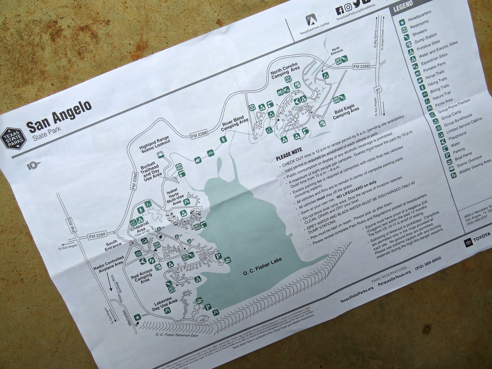
Over the years I have looked at this park, virtually anyway, several times, but frankly, without any other reference, the maps are confusing. And trying to reserve a campsite in this jumble of lines-on-paper is made more challenging by the fact that the various camping areas scattered around the park don't use unique numbers. There are at least 6 campsite #1's scattered around the park's two separate units and 7 different camping areas.

So I decided the only way I was going to figure this place out was to go see for myself.

I got an early start on this Friday morning since the park was 250 miles away from where I was in Caprock Canyons and I wanted enough time left in the day to check things out properly once I got there.

From Caprock I headed straight, more or less anyway, south on State Route 70. And for those that can't stand to dawdle and smell the roses for even a few seconds, the speed limit on much of this little two-lane road is 75 MPH, the same as the US Highways and Freeways in this part of the State. And I'll have to apologize in advance to those anti-dawdlers that, by the way, usually just end up sitting at the stop-light right in front of me anyways, because I won't be doing a lick over 65 so you will just have to go around.

The road does briefly slow down as it threads through several little hamlets and towns along the way, but the surprise was the town of Spur, pop 1300.

Allsups is a little gas station/convenience store that can be found all over this region, even the smallest of towns has one. But, probably as a result of being the only game in town, most of them are cramped, crusty, and rundown looking, so it was a bit of a surprise to roll by this spacious one in Spur which was clean and bright with a parking lot noticeably lacking in the usual open potholes and weed-filled cracks.

Unlike the other SR-70 towns of Matador, Dickens, and Jayton, Spur does not sit on an intersection between the state road and a US highway, it's just a spot along the road in the middle of a lot of white space on the map, but in addition to that sparkling Allsups Spur also has a brand new Dollar General.

Oh, and for those so inclined, there's an equally fresh looking Dairy Queen right next to the Dollar General.

I made note of this since Spur is only about 80 miles from Caprock so it makes for a good spot to top up the fuel and supplies before heading into the Canyons when approaching along this route.


I also made note of this official state picnic area about 11 miles north of the intersection of 70 and US277 (About 22 miles south of Sweetawater which has a Walmar for those that prefer that overnighting option) and not quite 200 miles south of Caprock Canyons.

In fact I pulled in for a short break and to look it over.

It looks well maintained though doesn't seem like it's heavily used, and sits below the level of the highway with a decent buffer of vegetation and shrubbery between it and the lightly used road above.

Caprock Canyons is just a little too far from home for me to make the trip comfortably in a day and still get to the park while the office is open for check-in (Otherwise I have to come back up about 6 miles of winding and steep park road to officially check in by 0900 the next morning, right in the middle of prime hiking time!) so this is another stopover option which puts me within easy striking distance of the park the next day.


San Angelo State Park is split into a North and South units with, based on the map, no apparent internal public road connection between them. (This map is printed with North to the right and South to the left)

When I went by at around noon on a Friday the North Unit gate was closed and locked. I could see this from the highway so didn't bother turning in to read the many signs hanging off the gate. Maybe all I had to do was press a buzzer or something to get in, but I didn't bother.

Instead I continued on to the South Unit gate where the woman in the booth was maskless. A first for me since last March. But all I had to do was flap my pre-printed day-pass at her and she waved me on by.


First stop, though technically I didn't really stop, was to drive straight ahead into the Red Arroyo camping area. These are a combination of pull-through and back-in water/electric sites with access to flush toilets and showers.

A pleasant enough area with well-spaced campsites, most with some sort of view of the lake, but I only tend to use water/electric sites where there's no other option.


Speaking of lake,


well - right now there's not much of it! (But more than there was nine years ago when it went completely dry!)

Not a big deal since this is primarily a flood control facility and only considered a secondary reservoir for the city, but I'm sure the fishing and boating folk would like to see more water!


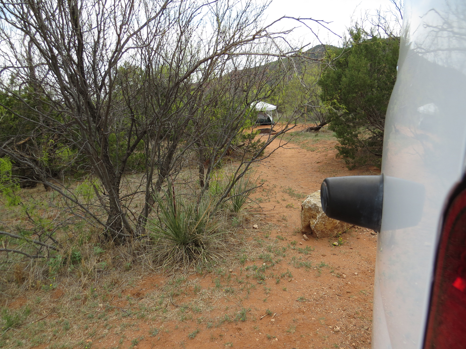
After cruising by the water/electric sites of Red Arroyo I moseyed on over (If you can mosey on 4 wheels instead of sitting in a saddle atop four legs.) to the Isabel Harte Multi-Use Area, which includes primitive campsites.

Although I would hardly call campsites with graveled parking pads and concrete picnic tables under hard-topped shelters primitive. I think it would be more accurate to call these dry camps instead and save the "primitive" label for those truly primitive sites. 

In this case there is, for those brave enough to use it, a water-spigot next to the shower-less toilets.

Regardless of what they call it, this is more my speed!

Although it doesn't show in the photo, this camping area is built on a slope that runs down to the lake so most the parking pads are not exactly level,


so, in anticipation of coming back some day for a more in-depth exploration of the park, I left The Van in that little parking area at the end of the road and walked the 25 sites of the campground, marking up my map as I went.

I crossed off those sites that are just too steep for comfortable van-camping. Sites that are passable I left unmarked. And I underlined the more desirable campsites, with #1, there at the far end, being my first choice.

By the way, this was a Friday afternoon, prime time for weekenders to be showing up, yet it wasn't until I was leaving that evening that a single camper pulled into one of the otherwise empty 25 campsites.


Right next to the camping area are an additional 5 sites that must have once also been campsites,


and still carry the numbers on the picnic tables, though the numbered posts out front are gone. That's because now these have been re-designated as day-use areas.


Despite the fact that the weather was closing in and starting to get a little wet, as long as I was already on foot anyway I decided to try out some of the many - many - trails


that twist and turn and overlap


and crisscross in a complex maze all over the park.


There's not near as much water involved as shows up on my map.

Some of the trails track along the grassy no-mans land between water and highlands, while others, a little further uphill, wind through a more wooded environment broken up occasionally with a small pond or swampy area.


At one point the trail I was on passed below some obviously abandoned day-use facilities


and as I looped back along higher ground later, I came across more evidence that this particular facility has been abandoned.

Clear indications that the park may not be seeing an especially high level of utilization these days. - Which is not a bad thing in my mind!

There were plenty of birds, deer, raccoon, and dueling turkeys to keep me company and I can do without the people!


There are a whole lot more trails to explore here at San Angelo State Park and now that I know a little more about what I'm doing, I suspect that I'll be back to spend a few days doing exactly that, but by now I was getting pretty wet, so I retreated to The Van, moved her a little ways up to the Highland Range Scenic Lookout, and kicked back to kill the rest of the day and make a leisurely dinner before heading on out to my over-night spot at a rest area near Eden about 40 miles away. 


Monday, May 17, 2021

Another Bactrian Kinda Day


Is it sad that I know a shaggy, two-humped camel from the Bactria region is called a Bactrian? Yeah, I think that's probably sad - - -

Anyway - the sun was rising into a clear sky and putting an end to my last night at Lost Maples.

Today (March 26) I have to give up my campsite to someone that reserved it for the weekend.

I could have headed on home to a washing machine, hot showers, and an evening of TV, but nooo - - - That makes too much sense and I wouldn't want to start getting that kind of reputation!


Instead I moved The Van over to the Murphy House Trailhead where I could leave it past the noon campsite checkout deadline without a Park Ranger getting after me and put boot to trail yet again.

Today I'm stringing all of the East then much of the West Trails together but bypassing Mystic Canyon by cutting off onto the north end of the service road that goes up to primitive camps E & F, which is the one little bit of "trail" I haven't hiked yet this trip.


This makes it another two-hump day, but hey! I'm not often accused of being smart.

I've just covered most of this ground over the past few days so will try not to repeat myself too much.


I almost bypassed Monkey Rock this morning.

After all, been there done that many times before.


but it's just a short side trip down a steep bank, (With rope handrails for those looking for a little help) so I decided what the hell.


And, as is usually the case, taking the time to make the little bit of extra effort was the right choice.

For about five minutes as the sun rose above the canyon rim the light was perfect. Better than shows up in the photo (Yeah, I've complained before that my camera doesn't always catch what I see.)


And as I headed back to the main trail that same light was doing a great job of rewarding me with this view 


of one of the Madrone trees.


This blaze is just in case you're confused about where the trail might be along here - - -


Having managed to stay on-trail with the help of superfluous blazes I worked my way through Primitive Camp A then past The Grotto to that slog up "the stairway" climb.

I know, not much in the way of "stairs" in this photo. Well I didn't think to take my camera out until I was above that part of the climb but still below the top.


And once I was on top of the ridge, you see that Roadrunner?

Yeah - me either.

She walked out onto the trail there where I'm pointing, took one look at me, and shot off so fast I swear her legs turned into little disks just like in the cartoon! Things like that could give a guy a complex about how ugly he is! 


I've been by this spot many times over the years, but this is the first time I noticed this old post lying not far off the trail. It was clearly not just a fence-post but rather a sign support at one time. For a pretty big sign too, since that flat area the sign bolted to is a good three feet in length.


It is lying right at the confluence of an X-shaped set of ridges where the trail makes a sharp turn from North/South to East/West, but it does seem a little elaborate for a spot where there's nothing now but the trail itself.

Oh well, who knows?


And I've never quite understood the thinking behind this short length of fence at the edge of a rock outcropping overlooking The Ponds below. (That Y shaped bit of blue behind the fence, though the left leg is shadow cast by the ridge and not actually water)

I mean if people are stupid enough to walk off the edge, then they are also stupid enough to walk around the end of the fence in order to walk off the edge - - -


Speaking of stupid - OK, maybe just foolish.

When I come down off this ridge (along the blue line) to The Ponds, instead of following Can Creek downstream (the green line) for just over a mile to The Van, I'm going to turn upstream for a while (the red line) then climb up the service road to the top of that next ridge over, putting The Van about 4 miles away - - - 

Bats in belfry??

Maybe, but what the hell, they're my bats!!


I didn't take this photo because of the implied rudeness of this stump, but because; if you look right near the top


this guy is giving me the beady eye reserved for all bipedal, yet wingless creatures that disturb her nap.


 Here's where I leave the trail and start the climb up the service road to the top of yet another ridge.

I'll pick up the trail again at the composting toilet I've named Nirvana then start down the other side of the ridge towards the trailhead.


Speaking of trailhead.

Once I finished up my hike and got back there I was kicked back in The Van with the doors open just enjoying the remains of the afternoon, because I'm only a little under two hours from the rest area where I'm going to spend the night and, as nice as that rest area is for a rest area, it's still a lot nicer here so I'm in no rush to leave, when a couple vehicles pulled up next to me.

Between the two, one a pickup, the other a large SUV, about a half dozen tween and young-teen boys and two adults piled out. I got the impression it was a scout or youth group of some sort.

Then, like a clown-car, they started pulling a mountain of equipment and supplies out of the vehicles as well, including backpacks bigger than some of the boys!

With much milling about and discussion, food was distributed among them, straps tightened and adjusted, doors slammed and locked, then opened again for some last minute forgotten item, then slammed and locked again.

Finally one of the men gathered everybody together, distributed paper maps, and gave the group a briefing on what their weekend, two-day, 10 mile, two different campsites, backpacking trip was going to look like.

He finished up by saying "Well we're running later than hoped so we better get moving." but one of the boys called out "Should we say something before we go?" They all thought that was a good idea, so hats were removed, heads bowed; and one of the boys, dwarfed under the pack on his back, said, in a strong, clear voice, "God, we thank you for getting us here today - and please let us live!"

AMEN!!