Monday, May 25, 2015

Texas State Parks Pass

I recently did a series of posts that included a few of the Texas State Parks. Steve, a fellow blogger, (And retiree!) commenting on my post about Blanco State Park , said that I was tempting him to make a slow trip through Texas.

That, and the fact that mine just expired, got me to thinking about the Texas State Parks Pass.

Most of the State Parks charge a daily entry fee. The fee is per person, not per vehicle, and if you are camping the entry fee is in addition to the site fee. This means that a water/electric campsite at Inks Lake (One of the more expensive parks in the system at $6 per person entry fee and $22 per night water/electric site fee.) costs a couple $34 a night, and if that couple has two children over the age of 13 then the cost jumps to $46 per night. (But then again, what teenager really wants to go camping with mom and dad??!)

Don't get me wrong, I still think a visit to the park is well worth it, but there is way to cut that cost down. One Texas State Parks Pass covers the daily entry fee for yourself and everybody else in the car. (Probably the only time 5 doors and three-row seating doesn't seem like a vain overindulgence!)  If you camp you also get four camping coupons worth half off the second night.(Hint, if you are a frequent camper don't waste those coupons on the inexpensive sites like Colorado Bend State Park. Save them for the more expensive parks.)

Doesn't matter if you are a resident or not, the Pass costs $70 and is good for one year from the time of purchase, (Actually it expires at the end of the month you purchased the pass so if you buy it early in the month you can squeeze 13 months out of it!) and can be purchased right there at most of the parks in the system.

Even as a solitary park-goer, it only took me 8 days  of enjoyment to recover the up-front cost of the Pass, (Including $20 worth of camping discounts.) after that the pass was paying me. I added an additional 29 days of park access and two more discounted nights of camping before my latest pass expired and by the time all was said and done, after subtracting the purchase price my April 2014 to April 2015 Pass netted me $186. That's a return of over 265%!! If I had been a couple instead of solitary, the numbers would have jumped to $400 and 571%!

Hard to argue against those kinds of returns!
(And yes, though it's sad, I do actually maintain spreadsheets like this. . .)

As a direct benefactor of the parks system I have no objection to paying for services and facilities as I go, therefor reducing the tax burden on those residents that don't use the park system, but at the same time I'm not stupid, (Most the time anyway.) if a discount or break is offered I'm going to take it! (I don't agree with Obama Care but you can bet your - - - tush - - - that, come time to file my taxes for 2015, I will be taking the government subsidy!!!)


Thursday, May 21, 2015

Wonders, big and small

I stepped outside this morning and within 10 minutes was gifted with the following:


A group of eight bucks browsing on the other side of the pond, all of them in velvet as they've started working on the bling for next fall's rut. Good friends now perhaps, but not so much once the Does come into heat.


This poor plant virtually covered in big fat, almost florescent, yellow aphids (I think that's what they are.) with striking black appendages sticking out of their over-inflated bodies.


And this delicate little cluster of 'shrooms.


Not a bad start to the day!!


Monday, May 18, 2015

Say what?!!!


We had a hum-dinger of a storm system pop up around 5 this morning. After the fact the weather dudes and dudets called it a surprise storm. (I guess that's how weather seers explain away missed forecasts. 'Oh, it was a surprise.' Like that's some sort of scientific phenomenon?) By the time it was over we had several thousand lightning strikes across the county, 4 more inches of water from the sky, three hours of power outage, (Though we are near the end of the wire on a rural electric coop, in the ten+ years we've been out here our power has been very reliable, more so than when we lived in the city, and this is the second longest outage we've experienced.) and two of our normal routes to a town 30 miles away (Decent grocery stores are not around the corner for us out here.) were closed due to flooding.

The long term rainfall average for our little spot on this earth is 16.29 inches by the end of May. With this morning's contribution we are now at 25.56 inches for the year and if it keeps up we will easily exceed our long-term annual average of 40.31. Now don't get me wrong, after years of severe drought we are very careful to avoid complaining about rain around here, but for crying out loud people! time to put those rain-dances on hiatus for a bit, and those of you that have been praying for rain; Cut it out!

By now you're getting pretty bored and wondering what the point of this post is. After all, who cares about the weather way over there when I have weather right here. Right?

OK, What prompted this post was something overheard during lunch at the restaurant. (With my wife along you didn't think we could go into town without eating out did you?!!!)

I couldn't see the two women in the booth behind me, but I could certainly hear them. (Whatever happened to inside voice??) I'm pretty good at tuning people out, (Just ask my wife!) but I couldn't help but hear one of them say, "It was so bad I couldn't see to pull over, or slow down, or nuthin'!"

At first it was pretty funny. In fact in our booth the piggin'-out was interrupted with half choked giggles there for a bit. (Didn't want them to know their private conversation wasn't so private in case they came up with any more gems like that.)

But then;  Wait! What?!

So bad she couldn't slow down?!!

Holy Carp!! Who is this woman and what's she driving because I sure as hell don't want to be anywhere near her out there on the road;   Ever!


Saturday, May 16, 2015

Oh the Horror!!


I got up this morning and had to GO TO WORK!!!!!

Fiends I mean friends of mine own the Orchid Tree Park and Gallery and usually when they go out of town on their little excursions they have one or another college kid come in and look after things for them, (The main campus of Blinn College is about 20 miles away.) but that's not how it worked this time.


This time they're off gallivanting around Santa Fe and here I am minding the store!!


It's been over three years since I actually had to get my butt in gear and show up for a job!


Last time I worked retail (If you can call a high end gallery retail. . .) was at my home-town Ace Hardware back when I was in high school; and believe me, that was a long time ago!


And I have to say, the hours here are brutal!

11 to 5 two days a week!!!

Can you imagine?!


Of course, among the real art around here,


they're foolish enough (Or feel obligated enough; I haven't decided which.) to have some of my own work on display.


But still, the conditions are medieval!

Just look at the view of the campground (In high demand during the semi-annual Antiques Week Festivals.) from the back deck where I'm spending my time between patrons.


Or this little bridge I have to stroll across


in order to get to the art-walk (A work in progress) at the back of the property


where I can plop down on a stump at one of the two walk-in tent sites tucked away back there. (Which are becoming a favorite of passing bike campers, with water/electric and private shower/toilet rooms back up at the gallery.)


Uh-oh, just heard a car pull up. I guess I have to go - man it hurts to say this - go back to work.

Don't you just feel sooo soooorry for me???????


Wednesday, May 13, 2015

A Tale of Two (New) Trails

I recently spent a week at Pedernales Falls State Park and during that time managed to hike two new trails, the Madrone and the Juniper Ridge. They are new in the sense that they don't show up on any official maps yet, but trails don't just happen overnight and some sections of these two trails are newer than others, thus they can be followed with varying degrees of confidence. (Confidence that you're still on the trail and have a fair chance of ending up where you expect, which didn't always work out for me as you will soon read.) I heard rumors of a hand-drawn map but didn't manage to get my hands on one until after I had stumbled and fumbled my way down the full length of both trails. (I'm a man. I don't need no stinkin' directions!)


This is a map of all my hikes in the 5000+ acre Pedernales Falls State Park since I started using a GPS almost exactly two years ago. There's a lot of overlap here as I've hiked all or portions of many of these trails more than once, and I don't always stick to the trails so some of the tracks above won't be found on any map, official or not, other than mine.


This is one of the new-fangled steel trail signs they are using now instead of the routed and painted wood signs. But don't expect the trails to be blazed with these. Between the two new trails I only found 3 of them, all a junctures with other trails.


And at one point, and one point only, I was guided by temporary signs that were little more than plasticized cardboard and had no actual trail names on them.


This track, near the southern border of the park, is the Madrone trail. From this it looks like the trail is a loop but neither the Madrone nor Juniper Ridge trails are actually loops. In this case the 8.5 mile hike was all of the Madrone and parts of the Juniper Ridge and Wheatley Cutoff trails.

If you look close you can see that my track has a short little tail on it near the county road right at one of the spots the power line crosses the road. There's actually a crude parking lot there, but be sure and go up to headquarters for a windshield pass before using it. The trail starts a couple hundred feet up the power line access road. It's hard to tell from the topo, but the terrain south of the county road is gently rolling, in sharp contrast to what you find in most of the rest of the park with it's ledges and steep ravines.


That terrain south of the county road is also prime real estate for feral hogs. Fortunately they always seemed to see me before I saw them and, unlike my close encounter of earlier in the week, the few glimpses I managed to catch were of them moving away from me at a comfortable distance. (There's a couple of them somewhere out there in the trees in the photo above but I can't find them now. Hogs are very good at not being seen.) Speaking of glimpses, I hiked this trail on a Saturday when the park's campground was booked to capacity, yet I saw only one couple out there, and then only briefly since their goal appeared to be covering the most ground in the least amount of time.


When I was hiking the section over on the north side of the county road, where the ledges are more numerous and the drop-offs steeper, I decided this rock would make a pretty good perch for taking a break. I got all my gear off, got the trail mix out and carefully positioned the pack just so to act as a backrest. I had just wiggled my butt down on the rock to adjust my cheeks into the right spot, preparing to settle down for a bit of relaxation when there was an almighty racket and a pair of black vultures exploded from almost underneath my feet, slapping their three-foot wingspans on the rocks, on the ground and on each other as they scrambled away. My relaxation was temporarily delayed as they went one way and I went the other!  OK, so they weren't actually right under my feet when this happened but over there under the rock the black arrow is pointing at, but that was still close enough!!


Apparently they had roosted here under this rock and were a bit reluctant to give up their spot, (If you look close, just above the center of the photo, you can see the blue drinking tube sticking out of my pack. That's where I had settled, blissfully, if temporarily, unaware of the neighbors.) but they couldn't take it once I settled down and got quiet; probably thought I was sneaking up on them. If they has just asked I'd have moved on and let them have the place; after all, by right's it's always been theirs anyway.

It doesn't look like it from here, but I'm standing on a pretty steep slope to get the photo above and the land drops away right there behind me so this spot offers a prime vulture's-eye view of the goings-on in valley below.


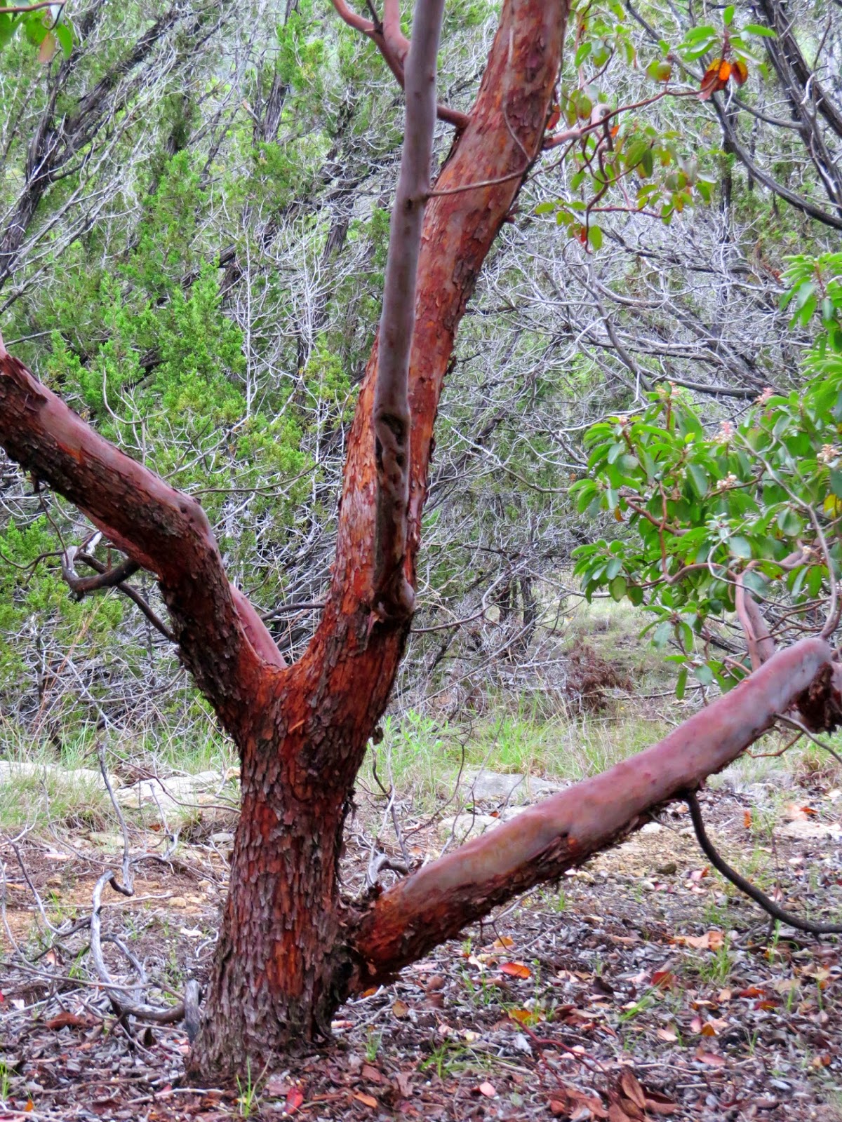
This is one of the few, bright red, exfoliating bark Madrone trees that I spotted and that the trail is named for. I understand the original name for the new trail was going to be Panther Junction, which might sound a little more adventuristery, (Or something like that.) but it actually makes no sense in this part of the country, so I, for one, like the name they ended up choosing instead. Trees might not seem exciting but the Madrone is unique and kind of rare.


The other new trail in the park is Juniper Ridge, and this one gave me a few more problems than the Madrone trail. In fact it took me two tries on separate days to get it right. If I had done the Madrone first I wouldn't have had the problems with Juniper Ridge that I did, but I didn't, so I did. (If you can follow that you're doing well!)


My first try at Juniper Ridge was just a couple tenths less than ten miles of pleasant hiking with some scrambling and slogging mixed in and resulted in the track above.

Seems like a perfectly good track when looked at like this, but


right there between the two black arrows things went a little sideways for me.

One end of the Juniper Ridge trail can be picked up by hiking the South Loop Horse trail about a half mile south from the Wolf Creek trailhead parking lot. (From the parking lot go due west a couple hundred feet to intersect the Horse trail instead of south onto the Wolf Creek trail.) At the juncture the Horse trail hangs left and follows a watershed down and to the east. The Juniper Ridge trail bears right and follows a narrow ledge hugging the edge of the watershed.

Hiking the loop counter-clockwise I had crossed a pipeline right-of-way there at the blue arrow. Having previously stumbled across another piece of the Juniper Ridge trail where it crossed the South Loop Horse trail (Right about at that north-facing point just to the right of the right-hand most black arrow.) I expected the trail to meander back across the pipeline right-of-way at some point so wasn't surprised when I encountered the pipeline(s) again right there at the left-hand black arrow.

The white PVC pipes appear to have been part of some sort of irrigation system at one point but are now all broken up and clearly unused for quite some time.

Only there was a little problem. The abundant, sometimes ridiculously abundant, surveyor's flags that had marked the new trail to excess, suddenly stopped and the trail hasn't seen enough usage yet to make it very clear, not on the hard caliche that passes for ground around here, especially when that ground is already marked up by decades of service vehicles following the pipelines.

The wide right-of-way actually accommodates two petroleum pipelines over there on the left, and one gas pipeline that I'm standing on. Expecting the trail to cross from one side of the right-of-way to the other, I did too. Only I could find no trace of the trail on the other side.


As this blow-up of my track shows, I wandered around a bit there near the left-hand arrow but still didn't have any luck finding where the heck the trail went. Not wanting to backtrack, I decided to just follow the pipelines for a bit since, if nothing else, I knew of a couple other trails that cross it farther to the east.

If you look at the topo lines and go back and take another look at the previous photo you might get a hint of the problem with this plan. Things can get steep out here and, unlike trails, pipelines don't do switchbacks, they just brute-force themselves in a straight line through whatever terrain comes along!

Unlike the original pipeline builders, I didn't have any heavy equipment other than my own two feet (and soon butt and hands.) to help me tackle this new challenge, I clawed and slid my way down the rocky drop-offs, made a little jog into the woods to find a place where I could get across the strongly flowing Butler Creek (That little dotted blue line.) without having to resort to the hassle of changing into and out of my water-shoes, then scrambled up the far side of the ravine, often pulling myself up on all fours. (I swear some big fat gremlin came along and sat down on my pack at this point because it was way heavier than I remembered!) By the time I found another trail over on the north side of the pipe line (Part of the Juniper Ridge trail as it happened.) I was one pooped puppy!

To make matters worse, I closed the loop by hooking up with Wheatley road and then the Wolf Mountain trail, only Wolf Mountain trail isn't so much trail as it is a hard-packed gravel and limestone slab road. This makes it easier for park personnel to get in and service the primitive camping area at the base of the mountain, but is also makes for a very tiring slog to finish up a long and frustrating day.


A couple days later, armed with some notes I took while talking to a long-time ranger of the park, I tried the Juniper Ridge again, clockwise this time for a little variety, and this is more what my track should have looked like in the first place.

The right-hand leg of this nine mile loop is on a section of the South Loop Horse trail, then I hooked up with the Juniper Ridge trail right there at the black arrow. The section of trail inside the blue boundary is what I missed on my first attempt.

What threw me that first time was the trail coming out on the pipeline right-of-way there near the purple arrow, then, after following the pipeline for a bit, diving right back to the south instead of crossing the pipeline. I didn't expect that because it seems to me that that ridge right there is gentle enough to get a trail over it without resorting to having to walk down the rather ugly pipeline, but then what do I know???


But then again, I'm pretty sure the Juniper Ridge trail was designed and built by a mountain bike club out of Austin and not by professional trail-blazers.

This has resulted in a few other bits of strangeness too, such as the spot there the trail switchbacks up, traverses a slope and switchbacks back down again. An aerobic little excursion, but the sharp-eyed will notice that the two initial points of the switchbacks are actually only 20 feet apart and separated by nothing more than level ground and a couple small cedars. And in another spot you can look down the length of a ravine and see the trail meandering aimlessly out and around and back until 1000 feet of trail ends up crossing from one side to the other of the ravine three times within 150 feet linear.

But it has also resulted in a trail that contours around the rugged terrain, minimizing the ups and downs found on most other trails in the park, traveling along ledges, hugging the edges and giving nice views down into the terrain below.

All in all, these two new trails are strong additions to the trail system in the park and give access to previously under-visited areas. (And if the new maps get delayed for another year or so, keeping trail usage light, I'm not going to be complaining!!)


Friday, May 8, 2015

Blanco State Park

If you hang around Texas long enough you will hear more than your fair share about Blanco TX. There always seems to be something going on in Blanco, (For example the Wild Women Weekend.) and when there's not a specific event going on to create a filler piece for the weekend news there's the obligatory summertime stories about beating the heat by floating the Blanco River in Blanco Texas.


I say Blanco gets more than its fair share of attention because in reality this is a little town of around 2000, located mostly on the north side of the river with a little spillover on the south side. (Including a gas station and the town's grocery store.)

Blanco State Park is a long skinny park along the banks of the river right there in Blanco. On one side of the narrow day-use parking lots is a strip of green and the river, on the other is a fence with a lane just on the other side. Across the lane are driveways, front yards and patios.

The red line is me wandering around.


But even though the park is on the smallish side, I still managed to do about three miles while strolling both sides of the river as well as making a loop through the campground, and there was still plenty of river bank I didn't cover. (It was a hot, and sometimes sunny day, more conducive to kicking back and relaxing than hardcore hiking.)


Not the low-water crossing! This is a dam above the crossing.
 
 
The campground, and about half of the available strolling, including the official nature trail, is across the river and accessed via a low-water crossing, which, given the drought of the past decade, hasn't presented an access problem for quite some time now.
(Edit May 25, 2015 I spoke too soon. A couple days ago 10 to 12 inches of rain fell right on top of Blanco and as of today the park is closed due to flooding. But most of the flood damage was further down river in Wimberly so I expect the park will recover quickly. Busting a drought is always a welcome thing, but it can also be a bitch!)


The campground, though it's right there in town, is actually kind of pleasant and has some pretty good sites, especially those at the back. As is my habit, as I strolled the campground I had my notebook out and was taking notes of which sites are first choice, which are OK, which are last choice and which are just plain unworkable, so I'm not flying blind the next time I come back. I'm sure people wonder just what the heck I'm doing as I stop in front of their camps and jot in my notebook, but so far no one has ever asked. In this case seven of the 31 sites made the first choice list and none were relegated to the unworkable column.


As are so many of our parks, this one was a CCC project and there are a few leftovers from those days. This little stone bridge being one of them.

When I'm standing next to one of these structures I can feel the labor of the men, the near-boys; I can hear their banter and bitching; I can imagine them washing up as best they can in a communal wash area at the end of the day and gathering in the mess hall with tin plates before finishing up the evening with songs and stories and letter writing, probably a few illicit games and maybe some quiet contemplation in the dark, before retiring to the barracks, or maybe simple tents, for the night. Only to start all over again the next day, and the next, with the majority of their wages sent directly home without them ever seeing them.

I often wonder just how many of those boys went directly from the camps to the military as the world started blowing up in the late 30's, early 40's, and if anybody remembers how many of them never made it back home at all.

It won't be all that long before that hand built bridge will be 100 years old and it's still in use today. Even when it was built it was just barely one lane wide and today is a driveway to a maintenance area, but it doesn't take much to imagine the parade of vehicles that once took turns using it back when it was part of the main road into the park.


I'm pretty sure this little stone shed was built around the same time as the bridge,


and this looks like the remains of a cobble road or path built down close to the river back in the days when hand-labor and craftsmanship were affordable.


All in all, though it's small, and I expect it can get pretty crowded at peak times, Blanco State Park isn't a bad little stop along the way.


Monday, May 4, 2015

Lady Bird Johnson Municipal Park, Fredericksburg


Fredericksburg TX has its charms, especially if you are partial to strolling main street and shopping for anything from T-shirts to high end artwork (Well out of my price range!!), or standing in long lines waiting for a table in order to eat good solid German cuisine. (The area was settled by Germans in the 1800's and still leans heavily on that culture.) If that doesn't tickle your fancy there's always the Admiral Nimitz Museum complex, which includes the National Museum of the Pacific War. Fredericksburg is the Admiral's home town and the museum is, in my opinion anyway, worth a stop.

But if none of that is getting your juices flowing there's also the Lady Bird Johnson Municipal Park.


Just be forewarned, Lady Bird is a beloved icon in these parts, in fact if this country embraced queens (The royal kind, though feel free to embrace as many of the other kind as you wish too.) she would have been crowned long ago, and there's a lot of places around here with her name on them, so make sure you have the right one.

I know; 'Municipal Park' doesn't exactly conjure up the most gentile and pastoral of images, but it's only a couple miles south of the frenetically busy town center and the nature trail gets some good reviews, so I wandered on down to see what it was all about. (In fact, other than stopping for some groceries, that was the sole purpose of my trip this day.)


Turns out the nature trail earns those good reviews.


It's not a long trail, and it's not one of those 'Holly Crap!' places but for a municipal park it's certainly an 'Oh wow!' experience.


The park also includes several sports fields 


 and as I wandered the trail I caught the occasional roar of a good hit or a bad strikeout,


but the way things are laid out the trail has a pretty secluded feel to it.


This beautifully built cedar slab bench was tucked all by itself into a far corner

and the inscription conjured up images of a dog, familiar with the trail, happily leading his man around the loop once or twice a week at a slower and slower pace as time inexorably marched on.


At its farthest reach there was a visual reminder that the trail shares this space with other recreational opportunities.


In fact, back near the entrance to the park is an RV park for those wishing to make more than just a day-trip of it. If you are an aircraft enthusiast this would be a prime spot to park for a few days since it is adjacent to the county airport. In fact I just missed getting a shot of a departing aircraft hanging there over the RV's. Being a little slow on the draw, by the time I un-zoned-out and got the camera up the plane was out of the frame.

All in all, a worthwhile stop if you happen to be in the area and need a break.