Monday, August 29, 2022

Family Reunion! - Ya Visto


Ya Visto - I Already Saw It - is a quick and dirty two-word Spanish translation of Deja Vu. A more accurate translation would be something like Sentía como ya esto hubiera vivido - I felt like I had already lived this - but that seemed a little cumbersome for the title of a blog-post.

Of course I could have just stuck with the tried and true Deja Vu (Yep, they use it in Spanish speaking countries as well!) and been done with it, but even though I only worked with them at a management level for 5 years and that ended 10 years ago when I retired, all things French still makes me cringe!

Anyway - if it's August, and I'm camped in the middle of a whole bunch of other people, then it must be family reunion time again!


These two photos were taken Friday morning (Michigan is a no-front-license-plate state so I didn't have to blur anything!) and all but one other rig with its accompanying tent (it was a somewhat large multi-generational twig of the family!) was already here at the campground, the majority of us having arrived on Thursday, well before the weekend.

That's because we did something a little different this time.

Rather than each of us reserving an individual campsite, hopefully in reasonable proximity to one another, one member of the family reserved a group site for all of us and divvied up the cost between the camping attendees. (we also have some day-trippers that show up for the Saturday group lunch who were only required to bring food!)

Unlike individual campsites, the group sites are only reserveable by the week. Your reservation starts at 1500 Wednesday and ends at 1100 the following Wednesday.

We had a couple rigs in place on that first Wednesday, and obviously filled the place up by Friday evening,


but this is how things looked after lunch on the following Monday.

I would also be leaving in a few minutes and that last trailer the following morning, leaving one completely unused night on our reservation, but even so, considering that each share of the cost for the week was about $80, it turned out to be not only a nice setup for a reunion but also a bargain for an electric campsite. (Where I was parked was pretty shady but plugging in to fire up my small shore-power charger would have required turning around and backing down a bit of a slope so I didn't bother. I'm loving my Battle Born Lithium Ion Batteries!)

There are 15 RV electric posts for each group site. a shared shelter (there are two group sites per loop.) with loads of electric outlets in each half for catering style equipment,  a fire ring for each group, and a couple water-points for filling jugs.


This is not a small campground by any stretch of the imagination!

As well as 12 group sites, 8 cabins, and 4 yurts, there are 287 individual campsites!

Full hookups to the west of the lake and water/electric sites to the east - the sanitary needs of the water/electric sites are accommodated with a 3 lane dump-station near the gate.


For entertainment there is the lake with a couple fishing piers and a canoe/kayak launch, a kayak and paddle-boat rental,

swim beach, bike rental, arcade, miniature golf, a half-basketball court, something called a BaBa ball pit(?), a couple of playgrounds,


a skate park,


a bike-skills track, and an open-air entertainment venue where they had a DJ'ed dance on Saturday.

Phew! Are we worn out yet?

Oh yeah! And almost as an after-thought, a couple miles of trail. (guess where I was while others were scraping themselves up on the bike-skills course!)


This photo is actually from several reunions ago. (Oh come on! You didn't think I, a security freak, would really plaster faces and names on here!)

Mom, who is in this photo and was there at this year's reunion, remembers going to the family reunion when she was a very young girl. (Damn girl, that was a looong time ago!) It used to be down in Ohio because that's where the larger portion of the family were and I can remember going to many of those. But over time our branch of the family grew, the reunion evolved, and the Michigan branch, the three siblings of immigrant Irish parents living near Detroit, essentially split off and turned it from a massive day-trip event along the lines of a small-town festival to a more manageable weekend campout.

When my generation's parents aged beyond the point of organizing things and passed the baton down to us Mom expressed some concern that the reunion would just die out. And for a while her concerns seemed justified. There were times when different branches of the Michigan crowd were under-represented and the head-count at the reunions started getting disappointing, (The head-count in the photo above was in in the mid 20's) but then the baton was passed down to the generation below us, or perhaps it would be more accurate to say that the baton was seized by the generation below us, and this year the head-count at the Saturday lunch was 38.

We haven't had that many people show up all in one place all at the same time in a long time. And next year's plans are already made.


But I'm getting ahead of myself.

Back here at this year's reunion, it's about a 2600 mile round trip for me to attend said reunions. This time it took me nearly three weeks from door to - well, back to the same door - and along the way way I made three stops (Not counting overnight sleep-stops) at two new places and two old places, (yeah, I know - even for me the math doesn't add up, but hopefully some of the following posts will sort that out!) hiked 6 new and one old trail, ate two dinners and one brunch with Mom at her community, ran into a class-mate - also 1200 miles from her current home - from over 50 years ago (good thing our respective Mom's knew who we were because we wouldn't have figured it out on our own!) visited a few places normally outside my comfort zone, and tried driving three different new-route segments. two of which I'll use again and one which I won't.

But that will all have to wait for upcoming posts. For now (as he sucks up the cringe)

Deja Vu Fin.


Monday, August 22, 2022

An End to the Boring Tour - Finally!

 I bet y'all were hoping I forgot and moved on to blogging about other things.

Well no such luck!


OK. For those lucky enough to miss out on the previous two parts of this tour, we're wandering the trails I've cut on our 14 acre property.

Their use is roughly equally split between my workout laps 3 or 4 mornings a week while carrying a 15 pound pack and more civilized rambles where I get to just enjoy being out in the woods


where, in our case, pretty much nothing is flat because of the three ridges (red) and the two waterways (blue) that we are blessed with.


To recap, this is an image of my trail map stripped down so the numbers are easy to see. The numbers, which are repeated as the caption of the corresponding images below, give you a rough idea of just where I was standing when each photo was taken.

- 15 -

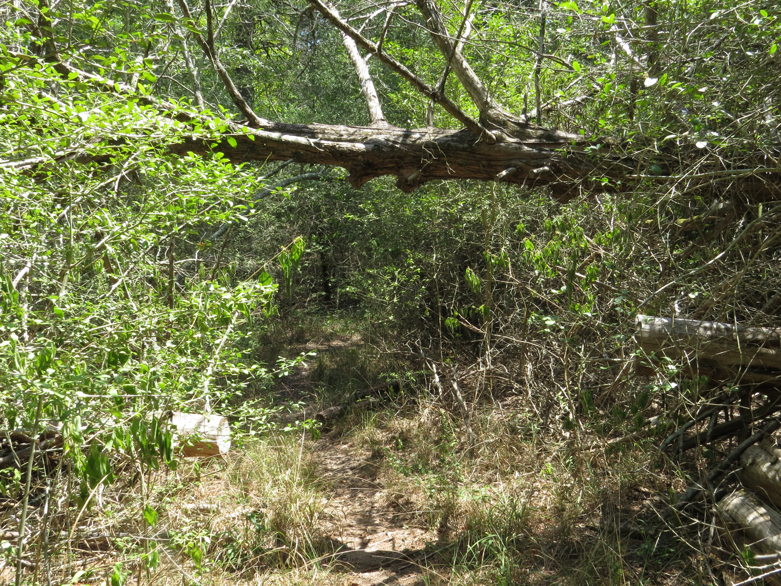
When we - OK - When I - left off last time I was about to duck through this vegetation-tunnel about midway across the dam and slip onto the back, the western end, of the property.

- 16 -

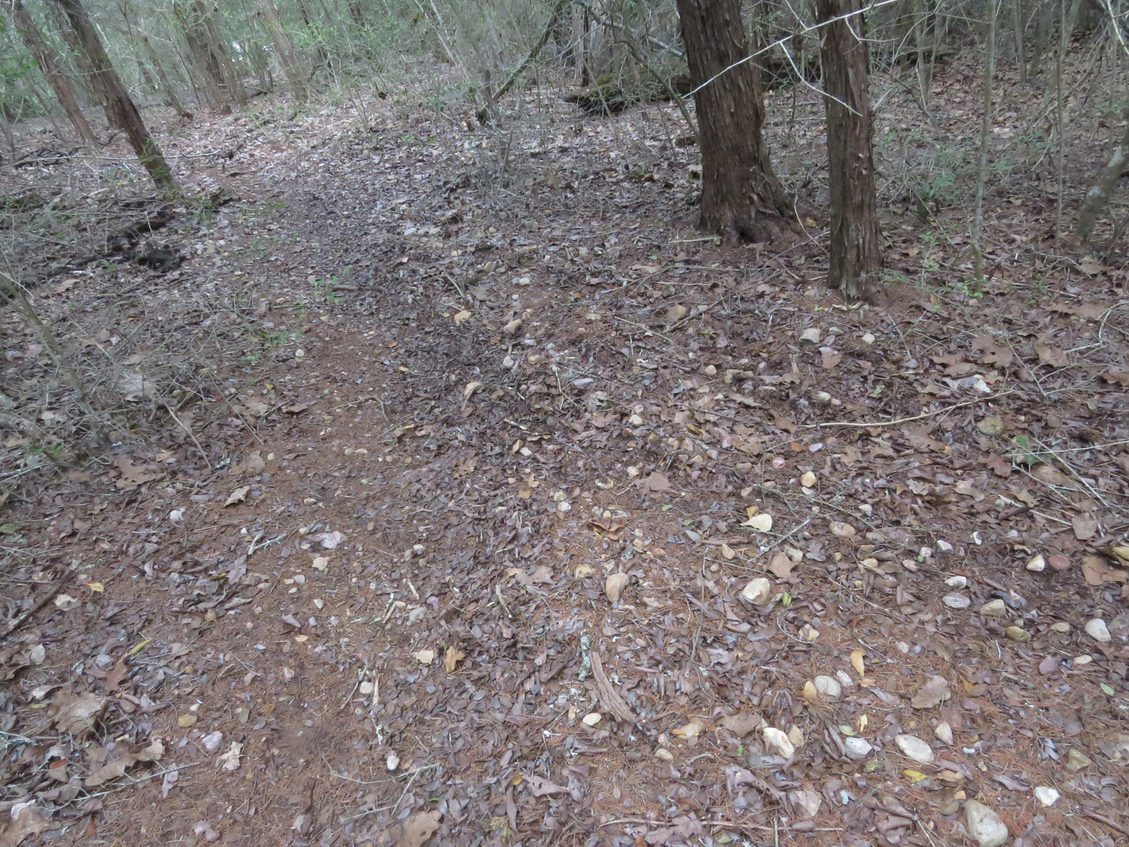
Just after crossing the earth dam I have this 4-way intersection mowed into the vegetation, again, mowed to cut back on the number of burrs I pick up when wading through during more lush times. In fact, if you look close at the ridge/waterway image above (second one of this post) about a quarter of the way up from the bottom and just a smidge to the right of center, you can actually see this intersection in the satellite image.

For me, down here on the ground and approaching from the dam side, turning left, or south, and then going a short ways takes me close to the south fence-line where the trail turns west again.

Going right, or north, I walk the length of the pond before re-entering the woods and arcing west near the north fence-line.

If I go straight like I usually do, which is what I'm going to do right now, I go west up the middle of the property. This requires climbing the steepest incline on the trail-system to get to the top of the middle ridge.

You can see a little piece of the trail I'm about to walk winding around a little more than halfway up near the right side of the photo.

- 17 -

But before heading up the ridge, a quick comment about the cleared area above the west side of the pond.

Again, not sure we would have put the pond in if it was our choice but when it was installed by the previous - short term - owners this slope was cleared in the process. From something those previous owners said at closing, I gather they intended to put a house on this side of the pond, using the dam as a driveway to reach it, which would have required a rather expensive bridge over the spillway for all-weather vehicle access and makes the placement of the well on the east side of the pond somewhat puzzling.

As I pointed out before, the contractor wasn't very good at his job and though you can't see them now that things have had 20 years to grow over, this slope is cut through with several deep and sharp-sided erosion gullies. (I actually got a 4-wheeler stuck in one when we first bought the place.)

We have left this area alone since we got here in 2002 so the cleared area is much smaller now than it used to be, but it still has a ways to go to get back to a 'natural' state.

- 18 -

OK Back to the trail!

Not far from the 4-way intersection that middle trail is like climbing stairs without the steps. - In other words, pretty much like climbing a ramp strewn with marbley-like gravel turning it into a slip-n-slide. But one with dire consequences if you do slip - and slide!

And when I turn that corner up ahead -

- 19 -

Nope! Not done climbing yet! (trail goes between the two trees in the distance, one leaning and the other, even more distant, straight up as if supporting the first.)

- 20 -

So up around that next bend and - 

                  Oh come on! Are you kidding me?!

Where's the damn top?

I hit this climb near the beginning of my workout laps and it's a good wake-up call for my legs. Lets them know we mean business.

- - - and feel the burn - - -

And to be honest, it's my own fault. On the other climbs/descents I threw in some small switchbacks to ease things up a little, but with this segment I purposely went pretty much straight up one side of the ridge and straight down the other to take advantage of the challenge. (According to the GPS the average grade over the entirety of my trail system is 5%)

- 21 -

Sometimes there are distractions along the way.

There used to be an antler-shed, just the one side - I have never spotted the other side - laying in this part of the trail. It started higher and for years it slowly wandered it's way down-slope. Sometimes staying put for months at a time before continuing it's journey. Apparently it found the trail to be easy wanderings because it stuck pretty close all those years. But I haven't seen it for a long time now so - good journey my friend.

In it's place today, perhaps as a sympathy card, was this vulture feather. Not an uncommon sight out here in these woods. Mom gets a kick out of hearing the birds when I'm on the phone with her (outside as always) but she's never heard one of these Black Vultures, who make no sound other than a raspy hiss and then only if you try to take their food away. Which I don't!

Maybe if I collect enough of these feathers I can finally fulfill that 8 year old's dream and jump off the roof and fly!

No?? Too stupid?

OK. Perhaps I better just leave it lay there and let nature do what it does.

- 22 -

So, I'll do the least stupid thing here and continue on, where eventually I make it to the large oak that marks the summit of the ridge. (It looks like this oak might succumb to the current drought.) 

- 23 -
But - 'goes up must come down' and all that, so I'm immediately heading down the other side of the ridge, ensuring that the down-slope parts of my knees also get a decent workout.

- 24 -

Four years ago, long after I had finished this segment of trail and was using it almost daily, I was suddenly confronted with this double blow-down after yet another wind storm.

Since it happens to be at the bottom of the western slope of the ridge, right where the second waterway runs, (I was standing in it when I took this photo.) everything around this location is very overgrown and difficult to get through.

So, instead of my usual, live and let live strategy of cutting new trails around blow-downs like this I drug out the heavy equipment 

- 24 -

and solved the issue this way.

For four years I've been sliding through here fully erect under that upper tree multiple times per week with no issues. But the other day I managed to put a good sized dent in my skull, not to mention my hat, and had a sore neck the rest of the day. (During my workout laps I'm moving at a pretty good clip and the neck is not a very good shock-absorber!)

Since, at my age, I'm clearly not getting any taller that upper tree must be settling!

One day I might have to do something about that, but for now I just have one more spot along the trail where I need to duck.

Now, let's see how long it takes me to learn that!

- 25 -

Today I make it through unscathed but am immediately faced with yet another uphill slog as I start the climb to the west ridge.

- 26 -

Finally on top of the west ridge and only a few feet from the western fence-line I come to a T intersection in my trail system.

From here I have the option of going either north or south.

But, being the mildly obsessive and ordered person that I am, I don't leave the direction to chance. Instead I use this feral hog jawbone from a skull that just happened to be here already when I cut this trail, to show me the way to go.

It's operation is simple.

When I come up the central trail and hit this intersection I turn in the direction the jawbone is facing. But before I leave the intersection I also reach down and turn the jawbone 180 degrees so it will be pointing the other way next time I come up the trail.

From here, depending on the jawbone, I will go to either the north or south fence-line, east, back over the central ridge, and down to the pond where I'll cross to the opposite fence-line and head west back to the T intersection again.

Since I sometimes get lost inside my head when doing laps and lose track of where I am, as I approach the T intersection from one side or the other I check the jawbone.

If it's pointing at me I know I've reached the halfway point of my workout laps and need to turn down the central trail rather than continue straight across.

If I turned right to go back down the central trail, when I get back to the 4-way intersection at the pond I turn left to loop back towards the west end of the property along the fence-line. (vice-versa if I turned left at the T intersection.)

But if, as I approach the T intersection and the jawbone is facing away from me then I know I've already done the central trail once in both directions and should continue straight past the intersection to the other fence-line before turning east again.

Sounds more complicated than it is.

And why bother?

Well the issue here is that because of terrain issues, going east to west along the north fence-line presents a more challenging climb than east to west along the south fence-line. So one day I get the challenging bit done and over with earlier in my laps when I have more oomph in my legs and the next day I'll have to power through the challenging bit later in my laps when there's a little less oomph left in the tank.

The scale is difficult to judge in the photo, but my newly rerouted trail makes a sharp right and slips under the trunk right in the center of the photo, just this side of that first major branch - and even with my hat on I don't have to duck to walk it.

- 27 -

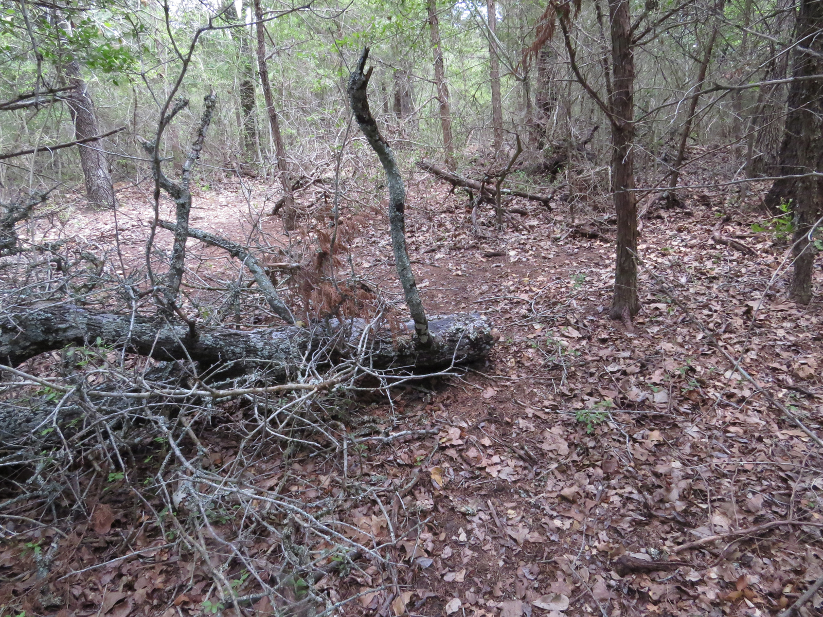
Three years ago this tree fell right into my trail. As the caption I wrote at the time notes, with a little trimming I was able to reroute my trail right under the fallen tree. (The crown is laying right on top of the original trail.)

- 27 - 

Same tree from about the same spot today. It lasted less than a year before that major branch failed and the main trunk fell the rest of the way down. Now my trail makes a sharp u-turn to the right just where I'm standing and around the butt end of the fallen log before continuing up the other side.

- 28 -

Some of the logs that were already down on the ground when I came through cutting trail were easy to go around.

- 29 -

Others, because of heavy vegetation in the lower areas, were not so easy to go around. One of these, in addition to being slippery when wet making stepping on top of it an iffy prospect, was a little too large to safely step over while also being able to see where your foot was going to land (on a snake?!) so I modified it with a step.

- 30 -

This is looking out over our fence to the north.

That's the Roberts' place.

We're not very enamored with the Roberts. We haven't shared phone numbers or permission to jump the fence onto each other's land.

Our issue with Roberts started when he, an insurance salesman selling farm and ranch insurance so he clearly should have known better even though he lived in the city, paid twice market value for the property which is exactly the same size as ours. This had the effect of increasing all his neighbor's property taxes, including ours, by a good bit the next assessment year.

He also immediately got pretty aggressive about trying to get us to sell him our place - to the point of jumping the fence uninvited three times that we know of. One of those times we discovered him right inside our barn. (Texas law allows us to use anything right up to deadly force to protect ourselves from trespassers so clearly this is not an overly intelligent man!)

And is seems we aren't the only ones not enamored with the Roberts. This spring he ran in the primaries for a State Representative seat. Out of a field of about 10 candidates for the seat he came in second to last.

Roberts plastered large campaign signs all over a 5 county area. The last place candidate had no signs at all. But then again, neither did three other candidates that garnered more votes than Robert's despite that.

Anyway, the Roberts' place looks different than ours right now because

- 30 -

he recently rented something like this (I wonder what that cost!) and spent the next 4 weeks burning expensive fuel every day grinding down everything except the larger trees.

Now the Roberts do have a couple rescue horses and one rescue donkey but this is the second time he's destroyed acres of habitat and cleared the land down to bare dirt, and I only occasionally saw any of the livestock utilizing it the first time, probably because there's nothing for them to eat out here.

If it's anything like last time it will just revert back to scrub, expensive scrub, in a few years.

- 31 -

But back to the trails!

Back down by the pond I shoot across the open space left by the pond-builder, go straight through the 4-way intersection,

- 32 -

and duck back into the woods on the south side.

Mine aren't the only trails out here though.

It's difficult to see in this photo but there's a crossing of my trail and a game trail here and the game trail is usually churned up by more traffic that my trail sees.

- 33 -

It's not uncommon for me to find carcasses in the middle of my trails.

After all, they, the trails, make for a nice open dinner table.

- 34 -

It's all a natural process and I just step over and leave them alone. We humans have done more than our share of interfering with the natural processes of the earth so I try to minimize my own personal interference wherever possible. 

Yes, the smell gets pungent, but that's a good thing. It's pretty much the equivalent of a pop-up restaurant posting fliers around town. And truthfully, by the third day (longer for Armadillos which, because of the hard shell, require a little more 'tenderizing' time.) things are pretty much cleaned up and it just smells like woods again.

In a few weeks there's nothing left but a small pile of bleached bones,

- 35 -


 and in a few months all that will be left of those are a scattering of a few of the larger bones.


- 36 -

After a dip down into the west waterway followed by a climb back up the west ridge, I'm back to the T-intersection and have covered every one of my trails in at least one direction.

This is the view over the back fence, the western boundary of our place. We don't know who owns that place back there, have never seen them, and have never seen any livestock over there despite the wide cleared area next to the fence.

And that's just fine with us. (The people side. We don't mind livestock.)

- 37 -

When not doing my workout laps out here I don't always stick to the trails.

In fact my little shelter in the woods is off-trail.


- 38 -

And the other day when I was doing some off-trail bushwacking on another part of the property I stumbled across this large den with two separate openings.

I find a lot of dens out here.

They are used by many of the critters we have in the area and no - I didn't stick my arm down there to see if anyone was home!

How would you react if some giant hand came through the window and started groping at you in your bed?

Exactly!

- 39 -

Alright, I'm sure I'll hear a big sigh of relief when I say that, while there may not be any hot-dogs or grilled salmon waiting, there will be something to eat by now, so I'm going to head back towards the barn now and that's the end of the tour.

So the rest of you just go home because I'm not feeding you!

- 1 -
(I know, another crappy photo courtesy of my phone-camera.)


Nope, not even the cows that look at me like I'm nuts for walking - briskly - up to the gate with a pack on my back a couple times most mornings.


Monday, August 15, 2022

Actually Getting the Unwanted Tour Started!

 Alright. I'm back - because there's no more hot-dogs - so I guess I need to continue the tour you never wanted in the first place.


OK OK.So I probably don't need to continue after last week's installment. 

But you know the drill: My blog - my content!


This is my trail map stripped of distractions, such as the ground and trees and stuff, so that the numbers, which match the numbers in the captioning of each photo and show about where that photo was taken, are easier to see.

- 1 -

And it just seems kinda logical to start at the front gate.

The camera has a knack for flattening things out (It's because the brain uses a narrow beam of the scanning eye to build a composite image while the camera uses a single glimpse through the lens onto a sensor with no spacial context and the resulting image is sort of flat. That's why I look fatter in photos than in real life - or that's what I tell myself anyway.) but it's really quite a drop from the gate down to that first turn at the bottom. Enough so that the 'auto hold' function on today's automatic transmissions comes in handy while sitting there on the inside waiting for the gate to open.

Years ago, after something like 18 inches of rain in 12 hours, there was a washout at the bottom of this section of drive. I threatened to dump some gravel into it to ease the passage of vehicles, but never did get around to it. No matter. It sort of slowly filled itself back in on its own - at least mostly -

And yeah, the green paint has almost completely flaked off our rather plain-Adrian gate,(Plain-Jane feels too much like I am perpetuating, and implicitly though passively agreeing with, the constant, sometimes subtle, misogynistic attack on females a certain segment of our society is so fond of, which I'm not, [fond of] so I went with something gender neutral.) but the galvanized steel underneath isn't rusting and we don't particularly feel the need for one of those flashy "Hey! Here we are! Look at us! Pleassssse look at us! Because we're so insecure we need your validation, or even better, envy." kind of entrances.

In fact, if, like most, you go by a little too fast on the county road and don't even know we're here that's great!

- 2 -

This is the view when you get to the bottom of that first bit of driveway and look around the corner to the south.

Yep, more driveway!

- 3 -

And finally, a little farther along,  a little farther south, there's another turn, to the west this time, and a glimpse of the barn! (at the end of even more driveway!) Still going downhill by the way.

- 4 -

But back to the trails.

About halfway down that first stretch of driveway one of my trails takes off into the woods. It's pretty hard to see unless you know it's there, but it is - and I know. (No, not there. It's actually to the left of that tree.)

And I call them my trails because The Wife, being somewhat grace-challenged (She falls down easy!) and demonstratively prone to breaking legs and ankles, (That's why we own both a walker and a wheel-chair!) sticks to the graveled driveway and has never set foot on any of the trails.

- 5 -

And this, even though you can't really tell, which is somewhat intentional, is where that trail comes out of the little segment of woods  between the power-line ROW and the county road, and drops down the cut into the pathway made when the power-line was being installed (long before our time here)

- 6 -

This is an example of a common challenge I face out on these trails.

In this case, within a few days of me cutting trail through here this old oak, now significantly decayed and less intrusive than it was when it first came down, fell right into my hard work and I had to reroute around it.

Re-routing is usually easier than dragging the chainsaw out here to restore my original trail with brute force. And by the way, because I'm not fond of the noise and don't see the harm is a little physical work, I cut, and continue to maintain, most of these trails by hand with loppers and hand-saws.

- 7 -

Here's another example.

At least this time it was years between cutting this bit of  trail and having the top of another dead oak fall into the middle of it during a bit of wind.

In this case I just squeeze by, trying not to get mortally stabbed by any of the branches along the way. I figure the flexing and contorting required 6 to 8 times a week does more good for me than the single workout required to actually remove the blockage.

- 8 -

Here I'm standing at the east fence-line looking down on the county road.

Again, camera quirks, but the bank I'm standing on is as high as the one across the road, which itself is higher than it looks here.

That's a glimpse of a little piece of a good-sized ranch across the way. They run cattle along with a smattering of donkeys mixed in over there. Donkeys may not look like it but they are vicious little things when riled up and many ranchers around here mix a few into their herds to help keep predators away.

They also have a hunting lodge over there and, in-between the drinking and grab-assing in the great-room, run guided game-bird hunts for those still able to get up early enough, although that income stream has been very light the past few years. COVID and all.

- 9 -

When they were making the cut through this ridge for the county road back in the late 40's they were dragging the diggers up the ridge with large cables.

I don't know if this one was damaged and abandoned on purpose or just lost in the shuffle, but it ended up right in the middle of where I was cutting trail.

Rather than wrestle with the thing that's had 60 plus years to integrate itself with the earth, I just left it there as yet another agility improving device along my way.

- 10 -

This is the south fence-line and I'm looking south-southwest across a piece of Ernest's ranch.

Up until a few years ago he ran cattle out here as well as managed more cattle on two nearby ranches. But Ernest himself is 80 now so these days he just hays instead. In fact he hayed this field just a couple weeks ago.

We like Ernest. We have each other's phone numbers. We have each other's permission to cross the fence-line onto the other side. (Here in Texas all it takes is a fence and a closed gate to say NO TRESPASSING, and we take trespassing seriously here in this state) and we talk across the fence at least once a year. (Ernest is a hell of a talker - me not so much.)

- 11 -

This is me, still standing at the south fence-line but turned around looking north along the ROW.

That's our transformer on the pole but the barn is still 250 feet away from there. I know because we had to buy that much 200 amp direct-bury rated (even though we put it in conduit) electric cable to get from here to there!

And yes, that is a line-pole our transformer is sitting on (line-poles carry the 13,800 volt transmission lines that continue on to service other locations.) but, although not a common practice elsewhere, our coop allows us to have our meter right on this pole as long as we run our line underground from the meter to our main box. 

- 12 -

OK, I've come down past the barn and am now standing in the spillway of the pond looking west.

As you can see, the water level is quite low at the moment because of that aforementioned drought we are going through.

There have been times when where I'm standing is under nearly a foot of flowing water. But not today!

On the horizon of this photo, there behind the treeline, is the middle ridge. Because of the intervening trees and camera-shenanigans it doesn't look like it, but getting from here to the top is equivalent to climbing about 150 steps, or up 7 or 8 story building.

The good news is that for the huff-n-puffery of every climb here on the property there is a corresponding descent that only requires puffery. The bad news is that, since I always end up back at exactly the same elevation as I started out, for every descent there is a matching climb!

Damn! I should have worked harder at loosing those last 5 pounds, because, of course, I can't just ditch the 15 pound pack I workout in! (OK, there are different levels of dummery, and this just might be one of them - - -)

- 13 -

Anyway: this is the view from the spillway up the other way back towards the barn

- 14 -

And in order to continue to the western part of the property, from the spillway I first have to make my way across the dam.

- 15 -

And to do that I've got to worm my way through the gap between the massive Live Oak on the left, the backside of the dam, and the Yupon and Juniper growing on the front-side and joining forces overhead.

This vegetation is persistent and every year I have to cut this tunnel back a little in order to fit the lawnmower through. As it is, when on foot I have to bend over to get through without getting my skull speared by a branch or two, and bend over even farther to keep from hanging my pack up on said branches.

Until recently we had an old, very old, 42" mower. Well it finally gave up the ghost this spring, as in dumping a nearly full tank of highly flammable, and expensive, gasoline on top of the running mower-deck right under my feet when the tank failed catastrophically, (Man did I bail out of there in a hurry!) and the smallest replacement we could find in stock anywhere was a 46".

Now that doesn't sound like much of a difference but I had to do some auxiliary pruning work to get the new mower through here the first time.

_______________

OK, so apparently while there's still no hot-dogs out back there is grilled salmon, so I'm bailing out again for something more interesting than this post.

But don't worry. I'll make sure to come back and bore you with the last of the tour next time.