You know how you sometimes see a little green sign when you pass from one county to another? But other times the only way you know you've left one and gone into another is a slight bump and a change in the road surface due to different road maintenance schedules and procedures? Well when I was southbound on I25 this morning I thought I passed the coolest county sign ever when I entered Spanish Peaks County.
Only it turns out there is no Spanish Peaks County.
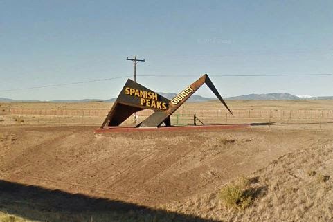 |
| Photo courtesy of Google Earth (Where I stole it from.) |
At highway speed, delighted at the the sculptural mimicking of the mountains with solid, heavy steel that still succeeds in soaring lightly into the air, I managed to read 'country' as 'county' as I went by.
Now personally I think Spanish Peaks is a much better name for a county than Huerfano, (Which means orphaned or devoid in Spanish.) but nobody bothered to ask me. Regardless, I thought the sign was pretty cool!
But, since I was hurtling down the freeway at the time - OK, more like turtling, but still too fast to snap a quick one-handed photo and no safe place to pull off, (In my humble opinion the shoulder of a freeway is not a safe place.) I later used the campground WIFI to go looking on the web for a photo of this unique and fitting sculpture, but surprisingly couldn't find one, so I ended up flying down the road on Google Earth and when I spotted it, helicoptered down to the virtual shoulder and screen-captured the image you see above.
But in the mean time. . . I'm supposed to be making my way towards home where I have a deadline to deal with, but not far from the Spanish Peaks Country sculpture I got distracted.

Way over on the far side of my laptop screen, which was acting as my GPS at the time, I noticed the edge of a 'map note' peeking through. That's it in the screenshot above, that little blue box down in the corner.
 |
| For the past several years I have been adding map notes to several different layers of my mapping system as I read about places I think might be interesting, usually in the blogs of others, and this is the map layer I was using as I drove today |
I was coming up on the Walsenburg exit at the time and got off to find a handy parking lot so I could take a closer look at my map. Once I could see the whole thing I realized this note was pointing at the Old Fort Garland Military Reservation, which is the official name of the Fort Garland Museum, and remembered putting it there (The map note, not the museum.) when I read an entry from Jim and Jackie Burton's blog Travels of the Mercury.
The museum is 50 miles away; 50 miles the wrong way and 50 more to get back on track; but hey, I've already got about 4500 miles behind me on this trip so what's another 100??
So off I went like a pin-ball that's hit an unexpected pin in the playing field, over North La Veta Pass on US160 and on down the other side into Fort Garland.
 |
| A shot of the 11,500 foot Mt. Mestas taken just before getting down to the business of climbing the pass |
For a bonus on top of a bonus, in 1899 the DRG converted the rails through here to standard gauge and moved the alignment about 8 miles to the south where it crosses at Veta Pass. (I know, all these variations on Veta can be confusing!)Today those tracks are still there and listed as belonging to the Union Pacific, though I don't know if they actively use them, but the Rio Grande Scenic Railroad does operate over these rails, of which I was able to catch a few glimpses of in the distance, but I didn't see any trains.
Anyway, back to what I was doing after getting ricocheted off my planned track. . .
On the far side of the pass I got to the town of Fort Garland. A few blocks south on SR159 and the museum is sitting there on the west side of the road.
What you don't realize until you study the map of the old fort, is that you just drove over the site of the hospital, now buried under the state road about where the tracks cross, and that the stables, kind of important for a Calvary fort, used to be sitting over there in the empty field on the east side of the highway.

Five of the original buildings are still here and many more that used to sit around the parade field have been reconstructed. After paying my $5 and passing through the gift shop I found myself out on the parade grounds with a number of exhibits to choose from in the buildings around it.

So off I went, counter-clockwise because - well - that's the way I'm wound.

In one building I came across this really cool piano.


A combination piano and table. Have a party and it can take care of the music while holding all the drinks and food at the same time! I've never seen one like this before but there was two of them here so maybe they were relatively common??

The barracks may be empty now, but I think if you listen real close you just might hear a few raucous echos from the days when this room was home to a bunch of testosterone laden men with not a whole lot in the way of available entertainment.


And I imagine the freighters passing through the area with their 'basic tech' equipment were equally tired by the end of the day.

As I wandered in and out of the various buildings and displays I kept seeing these floor patches made from tin cans and a few nails. These two seemed fairly recent to me but I can see the solders using the available materials and technology like this, except in my vision they're using the heel of a boot to hammer the nails home, to keep the varmint count, the native fauna, to a tolerable minimum.

Speaking of native fauna, as I toured the grounds I kept hearing the slow, ominous croak of these Common Ravens. I'm pretty sure that in some cultures that's not a good sign!

These guys, unlike the Ravens which stayed up there on top of their pole, were flitting around the grounds and, though I haven't taken the time to identify them yet, I'm pretty sure there's nothing ominous about them.

As I was leaving the museum this excursion train was sitting at a miniscule depot beside a more-field-than-parking lot with a tiny ticket booth and some stairs for getting into the cars. The Rio Grande Scenic Railroad web site only lists terminals at La Veta on the east side of the pass and Alamosa on the west side, but clearly something is going on here. The train was just about finished loading and I had other things I was supposed to be doing, so I didn't stop and check into it but it's another note to to add to the map.

Having just crossed it east to west, I knew the road over North La Veta pass was easy with two lanes for the up-bound traffic no mater which direction you were going and, finding myself on an empty stretch of it, I felt comfortable enough to snap this one-handed photo.
Speaking of passes, I don't think I've ever been over Raton pass, which I crossed later in the day, from north to south without passing at least one breakdown along the way, and since the shoulder along here is only half-width, there's really not enough room to be breaking down!
I admit Raton is a tough pass, though I'm not sure why. At 9500' North La Veta pass is about 1700' higher than the 7800' Raton pass and both passes have a maximum grade of 6%, but the main part of the climb to North La Veta is about 1600' over 7.5 miles where Raton Pass is 1800 feet over 12 miles. This means the climb to North La Veta should be slightly tougher than the climb to Raton, yet somehow Raton is a harder pull.
I ran North La Veta at about 55 mph (The road has just been resurfaced and was smooth as silk.) and the engine coolant temp only hit about 207F. On Raton Pass, even though I was going 10 MPH slower than that, my coolant temp reached 232 just before I topped the pass and I was preparing to slow down even more and downshift one more gear to keep the engine RPM's, and coolant flow, up. (With a 16# cap the boiling point of 50/50 coolant mix at sea level is around 270F so, not being a physicist that can quickly adjust for altitude off the top of my head, 240F is the max I will let it get to at this altitude. That way I don't risk boiling off my coolant and melting the engine, or, in the case of today's computer controls, having the computer suddenly shut me down at a really bad spot.)
But regardless of the why's, Raton Pass is not to be toyed with and I don't understand why people feel the need to blast on up it at the posted speed limit while hauling a heavy load. As I already said, north to south it's about a 12 mile pull to the summit and the difference between running it at 65 and making the climb at a more reasonable 45 with your hazards flashing, is about 5 minutes.
I just can't see risking the engine and transmission of a $40,000 truck hauling a $50,000 fifth-wheel with three slide-outs, massively tall stand-up front room, 32" flat-screen and a fireplace in order to save 5 lousy minutes.
But then I often don't understand people and the things they do. So it is with great effort that I restrain myself from tooting and waving gayly at the driver that just blasted by me a few miles ago but is now blocking half the right lane sitting there in his billowing, smoking truck trying to keep that 12,000 lb. trailer from dragging him backwards down the hill. He's just not in the mood for sarcasm and I-told-you-so's. . .
Every time I go over this pass I can't help diligently scanning the railroad tracks more or less paralleling the road.
Back before the Santa Fe was absorbed by Burlington Northern in 1996 I would occasionally see freight trains tackling the 3.5% grade despite the longer but easier 1.25% Belen Cutoff over to the east, but ever since the creation of BNSF the only thing that goes over the pass is the once daily Amtrak Southwest Chief and I've never managed to actually see it up there. But I like seeing the tracks anyway. I like imagining the work crews pushing the roadbed through the mountains and the countless engines that have labored over rails they laid. (But don't tell my psychiatrist because she doesn't know just how pathetic and sad I really am!!!)
No comments:
Post a Comment