Thursday, April 26, 2018

Plan A 2.0: AKA Will I Never Learn?


OK, after my brutal ‘bike encounter’ yesterday I did eventually manage to drag myself up out of my chair, though it was hours later, and painful. I’m pretty sure my original intent was to do something about dinner, but some masochistic streak buried not-quite-deep-enough inside me saw me picking the Quad-B up off the ground where, in an earlier fit of spite, I left her when the wind blew her over. Then, instead of doing something sensible like crawling into The Van and preparing my dinner salad, I found myself mounting the Quad-B instead.


The two of us, once more joined foot to pedal and saddle to butt, limped our weary way down along the river where we could watch the sunset away from the other campers.


It was quiet enough that this girl tip-toed her way along the opposite bank apparently unaware of my presence,


and this guy, his kind usually much more shy than this, didn’t seem to mind sharing a little quiet-time with me in the last of the rays.

That quiet little ride must have mended things between the Quad-B and me because the next morning found me loading her up for another attempt at Plan A.

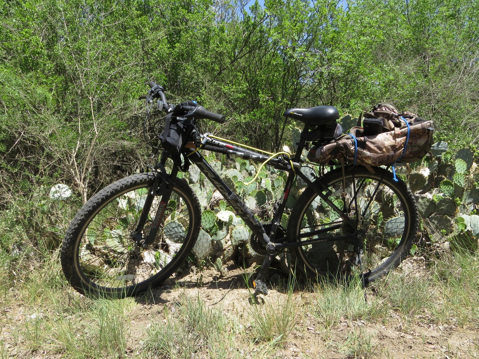
Pack strapped to the rear carrier, water-bottle/camera carrier on the handlebar, straw hat dangling down my back by its chin-strap, Tractor Supply ball-cap on my head with bike helmet over that, (For some reason most bike helmets don’t have a proper bill to shade your eyes) and most importantly, hiking sticks bungeed to the bike’s crossbar. (I double-checked that last point just to make sure this time!)

OK, let’s try this again!

That 3-mile-plus ride/walk up the River Trail wasn’t any easier this morning, but since I knew what to expect this time it somehow wasn’t as bad as yesterday.


This time I had all my gear with me, like I was supposed to yesterday but didn't, and when I got to the trailhead of the Gorman Springs Trail I was able to morph from trail-rider to hiker.

To get here it’s either the 3.4 miles up the River Trail or a mile and a half down the Gorman Falls Trail, both of which are bikeable, (Hey! If I can do it after that fiasco yesterday pretty much anyone can!) but since the Springs Trail is not bikeable a handy bike-rack has been provided.

Oh, and see that little white paper posted there just below the bird-house? That’s recommending you not let your little children run on ahead because there’s mountain lions in the area. . .


The Gorman Springs Trail meanders up the pleasant little valley/canyon formed by Gorman Creek which,


thanks to the strong spring at its headwaters, has a pretty decent flow for its relatively short length. (About a half mile from spring to trailhead then another quarter mile to Gorman Falls where it drops 65 feet into the Colorado River.)


The trail crosses the creek twice but at normal water-flows both crossings are dry-feet as long as you can stay on the sometimes slippery rocks, which, if you remembered to bring your two hiking sticks along, is easy.


The lower end of the watershed is a picturesque, pocket-sized valley,


that quickly starts morphing into the kind of limestone lined canyon which is more common for the area.


But other than a few riffles, there’s nothing ‘wild’ about Gorman Creek. Even when it goes over the falls (a different hike) it’s very measured and orderly about it.


The headwaters, where the trail ends, are a rock-lined pool into which the spring flows


and this is a good spot to shed gear and relax for a while.


I tried to include the toe of my boot so this photo would ‘read’ better, but I don’t think I was very successful. This is shot looking straight down along a foot-pipe that has been dropped into the pool right where the spring is bubbling up.


The other end of the foot-pipe is attached to this horizontal piston pump driven by an electric motor via a (missing) belt. The piston is tucked down there just below the electric motor and driven by the geared crank encased in a protective housing to the right.


Confusingly, the motor seems to be set up for a couple V-belts while the large drive wheel (a small piece of which is visible at the bottom of the photo) looks like it takes, or once took, a flat belt.


The discharge pipe, barely visible beyond the pair of 90 degree elbows where it arches up through the center of the photo, snakes its way up and over the edge of the canyon-rim above.  The Gorman homestead was up there somewhere but I suspect this pump hasn’t been used since at least the mid 80’s when the state bought the land.


If you're patient enough to sit still along the deeper parts of the creek you just might get a glimpse of the purest strain of Guadeloupe Bass left in the State.  I’m not sure if this is juvenile or breeding coloration, but the Guadeloupe Bass is generally greenish.


Later, as I was working my way back down the creek towards where I left the Quad-B a large bird noisily flapped its way out of the tree there in the background on the left and flew across towards that ledge just left of center. The noise initially made me think vulture, but as I briefly saw it in flight I thought Turkey?!

Turkeys don’t usually roost in the middle of the day, preferring to be on the ground foraging instead.


But I parked myself in an inconspicuous spot and settled in to wait for a while just to see what might happen.

Eventually, fooled into thinking he was alone again, this guy leisurely sauntered into view, though when he realized I was still there on the valley floor he did a double-take, turned, and head-bobbed back out of view as fast as his feet would move.


Not long after the turkey encounter I once again mounted up on the Quad-B and prepared to retrace my route back down the River Trail, pointed to there by the big red arrow on the right, battling up and down the various obstacles between here and and the campground, including heaving the Quad-B across that gap in the ledge over the mouth of Gorman Cave.

But  I had barely got my feet on the pedals when I was faced with my first challenge.

If you look close at the circled bit of trail, really close because the grey contour lines are kinda hard to spot, you’ll notice that that last little bit, the tail-end or the beginning, depending on which way you're going, of the River Trail is a bit steep.

In fact this is the lower end of the old Gorman Road where it switch-backed down the final plunge  off the bluffs to the river. That last drop is about equivalent to a 5 or 6 story building and now is a rutted, hard-packed chute of dirt and rock that is only vaguely related to a road; and it is really steep! (No photos because I was too busy surviving, both going up and down.)

Now here is where I broke my rule, the one that says if I would have to walk the Quad-B up then I also need to walk it down.

I don’t know why I broke my own rule. Maybe it was because I had just now got my butt on the saddle and was too lazy to get back off again, or maybe it was just because I’m a man and men do stupid crap. After all, it’s kind of our thing!

Remember the man’s prayer said at the beginning of every meeting of Red Green’s Possum Lodge? “I am a man: But I can change: If I have to: I guess” Well we have to say it every week because we actually never change. . .

Whatever the explanation for ignoring my own rule, I crept up to the edge of this downhill, grabbed for the brakes, and went over, desperately trying to pick out a line to avoid the worst of the ruts and biggest of the rocks while at the same time struggling to remember to keep my eyes open so I could look where I wanted the tires to go.

The motto of that same Possum Lodge is, ‘Quando Omni Flunkus Moritati’ – when all else fails, play dead – but there were a few times on that long slide down where I figured if I screwed up I wouldn’t have to ‘play’ dead at all!

But I made it unscathed.

Well – sort of.

You see, shortly after making it to the bottom in one piece (which I had to check a couple times before I believed it) I passed a family, mom, dad, two young children, and a terrier-sized dog, hiking the other way and I’m pretty sure they were well within earshot as I screamed the whole way down.

That was embarrassing. . .


Monday, April 23, 2018

Plan C - And It Kinda Sucked!


The plan when I set out this morning was a leisurely bike ride up the Colorado Bend State Park’s 3.5 mile River Trail which, as you’ve probably guessed, sticks pretty close to the river. At the end of that trail is the relatively short hike-only Gorman Springs Trail. After doing a slow and contemplative one-mile foot-born ambulation on this very pretty trail I would retrieve my bike and pedal the River Trail back to camp where I would put in some serious chair-time with a good book.

Things didn’t quite work out the way I planned.


Plan A fell apart about a mile and a half up the River Trail when I realize I haven’t brought my hiking sticks. . .

Yep, despite the carefully laminated checklist sitting right there inside The Van’s side door, on which the final item is Hiking Stick, I have neglected to bring them anyway. I mean that’s about as bad as a skydiver forgetting to bring his parachute and not realizing it until the plane is nearly at jump-altitude!

Gorman Springs Trail is not especially rugged, but it does include two creek-crossings and despite giving my bum leg the day off yesterday it's still pretty bum and I'm not too keen on attempting to splash around on slick rocks without my sticks.

And yes, sticks as in plural. I’ve been a one-sticker ever since I nearly fell off a cliff in Alaska back in the 80’s, but I’ve recently migrated/upgraded/devolved/downgraded (pick your ‘ed’ of choice) to two sticks. But that’s a story for another post. . .


So I've come up with a new plan for the day that doesn't include backtracking to retrieve said sticks.

This new plan, Plan B, keeps the leisurely-ride-up-the-River-Trail part from the original plan, but even that soon went to hell as well.


Long before I get to this spot, which is a little less than three miles from the campground, I have Stopped and Walked Bike several times already.

And when you add up 36 pounds of Quad-B (My Big Box Beater Bike) and 25 pounds of hiking gear, that sucker takes a lot of walking, up or down hill! And yes, my rule of solo-biker self-preservation out on the trail is that if I would have to walk it uphill, I walk it downhill as well. Doubles the walking but greatly improves the survival chances.

Recently another blogger commented that if you don’t have to get off and walk your bike a few times you picked the wrong trail. Which sounds all well and good, but he’s speaking as an accomplished, and perhaps somewhat crazy, (He hikes at 10,000 feet in knee-deep snow wearing shorts for crying out loud!!) single-tracker on a $1200 bike!

Me? I’m clodding around on a $120 bike, on which I’ve only had a few hours saddle time since last October, and with only one and a half legs! I'm sure if he knew what constitutes a 'walking section' for me he would be rolling on the floor with laughter.


Just as I’m sure little kids and most old men can handle riding down this short little rocky drop one-handed while carrying on a conversation over their shoulder, but it has me grabbing for the brakes and awkwardly dismounting, trying desperately not to drop the too-tall, top-heavy Quad-B in the process.

I sure don’t remember this trail having so many steep ups and downs!


This one I do remember. Except back in 2014 the trail went over the top of this old steam boiler casing which has been repurposed as a culvert. Clearly the water has washed it out one too many times since then


and now the trail has been permanently re-routed around it. Which makes for even more of a slog to push the Quad-B up and out of here. (Just like size and right-hand side mirrors, things are steeper than they appear in photos!)


As for that Stop-Walk sign, I was expecting that one too.

This is where the trail dips across the top of the opening to Gorman Cave, but back in 2014 you could still go into the cave, which I did back then, at least for a few feet. (But that isn't part of Plan A, or Plan B this trip. Just not that into caves.) Now it’s been gated off to protect the bats.


Besides being quite a dip to get down to the cave-crossing, there’s also this narrow ledge over the cave's opening to be negotiated.

Notice the crooked little tree in the center of the photo growing out of the ledge?

I don’t remember having to deal with that last time I was here,


but a check of my 2014 photos shows that it was there then too.

It hasn’t grown a whole lot since then, which is a good thing since I have to try to fit myself and the gangly Quad-B between the tree and the rock face. You know, the one with a cable anchored into it to help keep you from falling off the narrow ledge!


I especially don’t remember this section of ledge being missing! This leaves a 3’ vertical drop between where the Quad-B is and where it has to go next, and pretty much nothing to stand on to lift it down but air!

But looking back at the old photo it’s clear that the ledge was incomplete back in 2014 too. Of course back then I was on foot so wasn’t trying to horse 60 pounds of awkward, wheeled crap across the gap either!


OK, let’s just say that by the time I've left the River Trail behind and horsed the Quad-B up the Gorman Falls Trail to the Park Road near the north end of the park, about where the arrow is pointing, all thought of Plan B, piecing together a return route back to the campground from various trails roughly paralleling the road, has died as my wobbly legs dump me on my back where I lay in the hopes that someone will trip over me and perform a little recessitation.

Instead, after self-reviving because apparently no outside help was to be forthcoming, I capitulate, give up on Plan B too, and do the entire return trip, head hanging in shame, on the road.

And not even that is going to be easy! Aside from carrying the extra weight of humiliation on my shoulders, there’s several low-water crossing on this road and each one marks a steep up-hill, every one of which will soon defeat my legs, forcing me to walk while pushing that stubborn behemoth of a Quad-B up every hard-gained foot of altitude.

Back when we lived in the city our neighbor proudly brought home a $2000 road bike.  For that kind of money the thing was so sweet that all he would have to do was think about climbing on and that bike would effortlessly shoot off down the road without him.

I've done a little analysis and it turns out that though the Quad-B does have a little bit of bike DNA swirling around it's gears, it's actually much more closely related to a dump-truck. A loaded dump-truck!


Though the overall trend of the Park Road from entrance to campground is downhill, all the downhill is saved up for that last little bit of twisting, white-knuckled, brake-squeezing, butt-puckering road right at the end.


That last photo was taken about from where the left arrow is pointing.

The Van is sitting in site 45, where the right arrow is pointing.

In between the road falls over the edge of the bluff and reaches the river in the shortest, and steepest, possible way.

Are we having fun yet?


Even with Plan C, that long walk/ride of shame, saving me a half mile or more over Plan B, I still end up covering about 11.5 miles for the day.

Yep, a whole 11.5 miles on a bike, the most energy efficient transportation system man has ever come up with! I can remember the days when I could knock off 20 miles of relaxed, wind-in-the-face, wheeled bliss in less than two hours without even trying, and I'm pretty sure that right now, at this very moment, there's a whole gaggle of old English ladies pedaling, with long-skirted upright dignity, their basketed single-speed cruisers at least that far for a bit of tea and crumpets, but back at camp when the wind blows the 21 speed Quad-B over, I don’t have the energy to get up out of my chair, hell I don't even have the energy to hold my book up into bifocal range! So I just leave her lay there. . .


Thursday, April 19, 2018

Legacy Plaza


Goldthwaite is a town in Central Texas. It’s the largest town in Mills County, and as such is the county seat. But still, the population falls well short of 2000. (The 750 square mile county struggles to reach a population of 5000)


Though this town is a scant 10 blocks wide by 10 blocks long and barely has enough people in it to fill a modern movie theater,


somehow they have managed to put together the modern glass and steel Goldthwaite Welcome Center, the Texas Botanical Garden, and Native American Interpretive Center, collectively known as Legacy Plaza.
  
I don’t know how they managed it, I mean there has to be more patron plaques scattered through the grounds than there are citizens in town, but this is an amazing gem tucked away in this tiny town.


The focus here is on the Colorado River 600 to 10,000 years ago.

In the background of this photo is a ring of interpretive panels talking about the life of the people that lived here back then.

To some eyes the foreground might look like a neglected picnic grounds, but what you're looking at is a diverse eco-system of native plants providing a rich, and sustainable, habitat for indigenous fauna.

In between is a creek bed used to collect rainfall off the butterflied roof of the welcome center and feed it into a cistern to support a water-feature that acts as a backdrop to the amphitheater.


A sample of one of the interpretive panels


In addition to the interpretive panels up front, there are others scattered throughout the gardens, some of which include hands-on  projects to go along with them.


Including


this work area for knapping your own flints. Apparently very popular with the kids brought through here in a steady stream of field-trips.

And since no-one was looking (The San Saba Garden Club came for a tour that morning but was gone by the time I got there) I tried a little knapping myself.  (Hint, if you don’t do it right it hurts!)


In addition to an interpretive center, Legacy Plaza has become sort of a community center as well and this large shelter with adjacent bathrooms has been erected in the southwest corner to facilitate that.

The amphitheater seating


All in all, an impressive place and worth a stop if you’re in the area.

Just pull off on the very generous double-wide shoulder of SR-183 between Second and Third Streets and wander on in.


Tuesday, April 17, 2018

The Regency Bridge, Up Close and Too Personal!


The day after hiking the Spicewood Springs Trail I thought it prudent to give my bum leg a break.

Oh. Did I not mention I was hiking on a bum leg? Well that’s probably because when a guy gets injured he really wants a story to go along with it, ideally a heroic story. Well I don’t have one and frankly, that sucks!

Instead of a riveting tale of battle with dragons or an incredibly brave, dare I say near impossible, rescue of a comely and, of course, exceedingly grateful maiden, (though just what the hell I’d do with an exceedingly grateful maiden I have no idea. . .) I got nuthin’.

I just woke up one day, stood up, took about three steps, and realized my leg hurt like hell. Not only do I have no idea what I did to it, I can’t even pinpoint when. Other than sleeping on it wrong, which is just - well - wrong in so many ways, the likely culprit is when I was lifting the pieces of Elmer’s porch into the trailer so it could be moved. But we didn’t take him to the airport for another couple days after that and I don’t remember being damaged goods (any more than normal anyways) at that point. And considering how much shit that leg was giving me you’d think I would remember.

 Anyways, by the time I headed out to Colorado Bend State Park I was no longer falling to the ground and screaming loud enough to make dogs run for their mommies every time I tried to put weight on the leg, but it still wasn’t quite right.

So Tuesday morning I left the hiking gear stowed and saddled up The Van for some internal-combustion ambulating instead.


Photo by Sean Lynes

About 25 miles northwest of San Saba (pop 1000) is the little community of Regency (pop ~50). Actually, since the Post Office closed sometime in the 1930’s and the last store in 1971, now Regency is more like a named area, a loose collection of driveways and ranch gates, but ranches were, and still are, an important part of the economy in these parts and the nearby single-lane, wood-deck, Regency Bridge is the only crossing on a 30 mile stretch of the Colorado River.

If you’re not from Texas you’ve probably never heard of the Regency Bridge, but if you’re a Texan the Regency Bridge is semi-famous. In fact it features prominently in the opening sequence of the current episodes of the TV show Texas Country Reporter.

The first bridge here, a through-truss built closer to the river, was built in 1903 but fell down In 1924 under a herd of cattle (and a 9 year old boy). The second bridge opened in 1931, another through-truss built on the original abutments, washed away in 1936. The current bridge, a wood-decked single-lane suspension bridge 403 feet long (325 feet between the towers) and about 80 feet above the river, quite a bit higher than the original bridges, was built in 1939 for $30,000. With the exception of one gas-powered cement mixer, a winch-truck and a steam-shovel it was built by hand by workers earning 30 cents an hour,


and working hard manually stringing the nearly 1000 wires that make up the main cables because there was always someone nearby that wanted one of these New-Deal jobs.


The roads have been readjusted since then and the importance of the bridge faded along with its paint. While not impossible to find nowadays you do have to work at it a little.

From the north there’s a sign for the bridge at the intersection of the paved FM-574 and the gravel CR-433. The bridge is about 4.5 miles to the south.

From the south, just north of San Saba at the intersection of SR-16 and FM-500 (Both paved) there's a sign for the Regency Bridge pointing north down FM-500. But the bridge is not on FM-500. To get there you have to turn off of FM-500 onto CR-137 (gravel).  There is a sign marking the county road, but no sign for the bridge. And most maps don’t identify CR-137 at all, including Google Maps which shows the road but doesn’t properly identify it.

Google Maps would trick you into looking for CR-433, which is identified there on the north side of the river, but the river is also the dividing-line between Mills and San Saba counties, which also changes the name of the road.

Once you find CR-137 it’s not quite a mile to the bridge, but this is a narrow and sometimes steep road so if it’s been raining hard, which is not unknown around here, you might want to walk it first before you get stopped by a wash-out and have to try to retreat, up-hill and backwards.

Both CR-433 and CR-137 are narrow with no shoulders, therefore no place to pull off. The exception is a wide-spot in the road, a sort of pull-out, on the south end of the bridge that will accommodate 2 or 3 cars, but this is not a place you want to be trying to get to with a motor-coach or travel trailer.

There are two private driveways near the north end of the bridge but do not park in them!  It pisses off the landowners.


The bridge is surrounded by private property, which is why this is the best I could do for a side-shot of it.


So did I drive The Van across this bridge?

Nope!    Niet!       No way Jose!!

As you can see, from one end you cannot see the other. The way you tell if there’s a car coming across at you is to watch the cables which will dip and sway as the bridge ripples under the weight of a vehicle. If no dipping or swaying feel free to drive on out there, but only if your gross weight is less than 8000 pounds.

Since The Van comes in right at 8000 pounds, or at least did many years ago when I trailered a load of scrap metal over the scales at a recycler, I decided to err on the side of conservancy and stay off the damn thing!


OK, you’re right, that’s just an excuse. Truth is I'm pretty sure The Van comes in more like 7500 pounds with me in it, but the thought of driving out there in The Van scared the crap out of me.

I know that as a member of the male subspecies I’m not supposed to admit things like that, but it is what it is. Hell, just walking out there with nothing more than the weight of my camera and hat scared me bad enough!


But in order to reclaim some tiny little remnant of my male dignity, sidle on out there one half-step at a time I did.


Of course the sight of one of the wooden supports holding up the guard rail, such as it was, dangling out there in mid-air like that didn’t help quell the fear-factor.


Nor did discovering that this saddle, you know the one holding up one of the iron rods that's supposed to be holding up the deck I’m currently standing on, has slipped a couple of inches down the cable since the last maintenance.


I tried moving over to the west rail and ignoring the major defects over there along the east rail,


but you know what? It’s still pretty damn high up here and you can’t see it in the photos, but the wind is brisk (OK more like a gentle breeze) and there’s definitely some swaying going on!


Ahh, that’s better, something solid.

But wait! Between wind-gusts can I actually hear those cables creaking?!


Saturday, April 14, 2018

Lopsided!


Here I am, innocently out putting the first hikes on my new boots aannnd. . .


At the top of a particularly steep climb I throw myself down to enjoy the view – OK, more like collapse to catch my breath and let the burn in my legs dissipate –  when I realize that said new boots are lopsided! Either that or my left foot had developed a new twist – but, out of loyalty to my foot I’m going with the boot.

The toe-cap is decidedly skewed to the right.

If I let my mind run free it almost looks like the damn thing is winking at me! (OK, I admit that it helps to be out of breath and have burned most of the morning carbs too)

How cool is that! I have a unique pair of boots. At least I assume they don’t manufacture them like that on purpose. . .