Sunday night! At last!!
In a few hours the visitors from
hell; AKA the long divorced parents; AKA the parents that, for some cockamamie (How's that for a good, old-fashioned kind of parenty word?) reason decided to share the same space together for the first time since 1983
and do so while just dropping in on the kids, will finally leave!
Time has run out
and they’re going their own ways, leaving the kids to pick up the shattered
remains of their psyches. Allowing the mistreated and abused, The Daughter, The
Son-In-Law, and Lula the canine fur-kid, to collapse on the couch, (Ahhh, our
own couch all to ourselves again at last!) where they’ll cuddle together (Lula
in the middle of course.) and talk bad about The Parents.
Oh, they’ll deny that last bit, but
we all know that not only is bad-mouthing The Parents in the rule book, it’s
also one of the constitutionally protected perks of living under your own roof
and not theirs. (Haven’t seen that part in the constitution? You’re just not
looking hard enough!)

One of The
Parents, undoubtedly the smart one, will soon be stuffed into a plane to be
whisked back to her own home in a matter of hours. The other - well turns out he’s
not quite so smart. (Guess which one of
the two I am. . . ) As the sun sinks that Sunday evening he slinks off a mere
dozen miles south, hangs a left and quietly rolls back into Oliver Lee State
Park, returning to the scene of his recent, and decisive, TKO at the hands of Dog Canyon National Recreation Trail.
There he sets up camp and whiles
away the sunset alternating between reading and glowering up at the mountain
that chewed him up and spit him out only days ago.

At dawn the next day I’m standing at
a fork in the trail with a decision to make.
And like the withered up,
comb-over Lothario that won’t take the hint and hang up his ascot and crusty
old pickup lines; like the tubby office-bound suburbanite that insists of
shoveling snow right up to the heart attack; like an aging prize-fighter that
doesn’t have the sense to just lay down and take the count; like a - well - you
get the idea. Like all those reality-challenged, most likely delusional, guys, I hang a right and step back into the ring.

By the time I cross back into the
National Forest for the second time on this difficult trail (The Forest Service's word, not mine.) and look back I find the rising sun has
chased the shadow of the Sacramento Mountains across the Tularosa Basin to
within 4 miles of the escarpment. (I know the distance because US54 is out there four miles away, right at the juncture of shadow and sunlight.)
Notice the notch in the shadow just
over the right-hand fence-post. It’s created by the deep scar of Dog Canyon. I
don’t know for sure, but I suspect that the little community of La Luz, a good 15 miles north of here,
got its name because it sits right there in the same sort of shadow-notch
created by another canyon. (La Luz translates as The Light.)

But anyway, back on the mountain: that
first bench is still at least as far away as it was the previous time I hiked up
here, though I’m not entirely sure it wasn’t even farther! But I make it and,
ignoring the well-meaning pleadings from my corner to throw in the towel during a short rest, at the bell I jump back in the ring with determination in my eye.
Yes, perhaps it is misguided
determination, but it’s my determination dammit!

Eventually I reach the site of my
previous defeat, that faded wooden sign warning that the line cabin ruins are
still a full mile, and half a mountain, away.
I get there just as the sun is peeking
over the rim of the canyon, which might be an omen, but an omen of what I don’t
know.
Daylight comes late to the southern
slope of the canyon because of the nearly vertical 1500 foot wall hugging it there to the south, so don’t
let the ‘rising sun’ fool you, by the time I get here it’s already 9:30 and
I’ve been on the trail nearly three hours. . .

Unlike Rocky Balboa, I don’t have an Adrian
over in my corner to draw inspiration from; in fact nobody even knows I’m up
here except the voices in my head, and they can’t seem to agree on whether this
is a noble cause or a dumb-ass-stunt; but I push on anyway with bullish determination
(OK, so yeah, bullish is usually the mashing together of bullheaded and
foolish, but I’ve learned to live with it.) and tackle the switchbacks that knocked me on my ass the last time I faced them.

A half mile and 500 vertical feet
later I reach the second bench.
And I mean Wow!!
The second bench makes the first
bench look like a three-legged milking stool!

Despite the passing morning the bench is still more than half covered in the shadow of the canyon wall, but this place doesn’t need
direct sunlight in order to sparkle.
With an eye tuned more to the
desiccated tans and browns of the basin below, the bright green of succulent leaves up there on the slope shine against the
darker Juniper,


by exuberant splashes of spring color make the place dance, sun or shade.

Even some of the trees

get in on the act and add a little of their
own glitter to the scene
And there is plenty of space for all
this sparkle. From the base of the
cliff towering overhead across to where the mountain drops off towards the river some
400 feet below, (Creek, river, it’s all a relative thing and around here it
doesn’t take much to reach river classification!) from the top of the
switchbacks up to where the trail drops off the far end of the bench, is an area a
quarter mile wide and a good half mile long.

It’s early spring and at a black-spots-in-the-vision-inducing altitude
of 6000 feet, with Burnt Ridge hugging it to the south keeping the desert sun away
until late in the day, this place is lush with a capital L. The lushness nearly
choking off the lightly used trail in a couple spots

And it’s flat here on the bench!
Well not exactly, but compared to
most the rest of the canyon this place is nearly billiards ready!
Which means there’s plenty of room
on this bench to spread out without getting into any serious climbing, and this
makes it a favorite overnight destination of back-country campers, but apparently not today since I
see absolutely no one else during my entire hike.

But as inviting at the bench looks, don’t
make the mistake of thinking the place is benign.
Yes, compared to lower elevations,
vegetation-wise, this place is a virtual paradise, but it still has plenty of
things that will poke and slash you, there’s no surface water available up here, and this house-sized
pebble, currently sheltering a couple of Alligator Junipers, got here by
falling off the mountain overhead.
I’m sure it made quite a racket on
the way down which is a good thing because if any more of the mountain wants to come down and join it I’ll need every bit of warning I can get to stay out from under!

All the way up here altitude and
verticality have been tag-teaming me, which seems a little unfair but what can
I do? Oh I suppose I could turn around but this has become personal, it’s
between me and – well – me, up here. (Face it, the mountain doesn’t give a damn
so it’s never me verses the mountain.) I won’t deny that being tag-teamed
hasn’t hurt, hasn’t delivered a couple good body shots, taken the spring out of my step (Oh who am I kidding here, more like destroyed the suspension altogether!) but here on the
relative flatness of the bench, verticality is temporarily banished from the
ring and I get a second wind.
But as pleasant as this respite is
is, as I make my way towards the far end of the bench, the canyon seems to be
pinching off as Burnt Ridge to the south (Right in the photo) and Juniper ridge
to the North (left in the photo) look to be on the verge of meeting somewhere
up there ahead of me. So I have a feeling that verticality is about to jump
back into the ring – properly tagged in or not.
By the way, you see those two ledges
hanging off Juniper Ridge there on the left edge of the photo? I didn’t know it
at the time I took this, but that second ledge from the top is going to become
pretty important to me in the near future!!

But first I come to this.
The point where the trail drops off
the upper end of the second bench and descends a little over 100 feet

to the first surface-flowing section of
the river since the mouth of the canyon.

And here is where the stone ruins of
a line-cabin, using one of those mammoth fallen rocks as the back wall, sits just
on the other side of the river.
This is where the ranch-hand that drew the
short straw stays as he keeps an eye on the herd partaking of the gourmet delights of
the second bench.
This is also where the vast majority
of hikers that make it this far call it a hike and turn around to make the
return trip back down the canyon.
That’s my plan too, but as some of
you might have surmised by now, there’s something wrong with me!!

It all starts out well enough. I’m
kicking back not far from the cabin ruins tucked over there between that dark tree to the left and the smaller but brighter one near the center, enjoying a nice comfortable breather - well, as much of a breather as the thin air up here allows - and glowing in the satisfaction of
pushing myself up the mountain without dying. But before graciously accepting the accomplishment and retracing my steps I make
the mistake of pulling the trail guide out of my pocket.
You see, technically this riparian paradise,
so hard won and well deserved, isn’t actually the end of the trail.

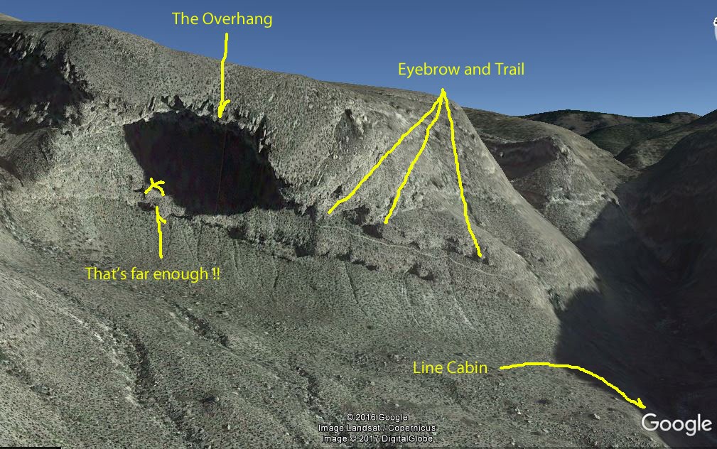
Remember that photo where I talked
about the second ledge from the top?
Well here’s my current view of the
same ledge from almost directly below it. According to the trail guide this
formation is called the Eyebrow, and the continuation of the trail is up there on that lower ledge!

Here’s another view of the Eyebrow
from back there on the second bench.
After a near-vertical scramble up a
fault in the cliff, there at the yellow arrow, the continuation of the trail (in
red) teeters along that ledge

before, after a final hair-raising
traverse across an ever-narrowing ledge, making another near-vertical scramble
up a different fault then finally
swinging in an only slightly less vertical arc towards the top of the ridge.
Oh, and by the way, that’s still not the
end of the trail! Beyond this point there’s nearly a mile of pinyon-pine forest
covered ridge to be negotiated before the trail officially ends at Forest Road 90B. But don’t count
on a shuttle picking you up there because that involves 20 miles of highly
questionable 4-wheel-drive forest road before it eventually comes out on US 82
at High Rolls.

The official guide says
“The trail across the Eyebrow above is a challenge for even the experienced hiker. It rises 1000
feet in 8/10th of a mile”
Now any normal person would read the
warnings in the guide, look up at the Eyebrow looming so menacing, all skinny and high up there, then kick back and enjoy the significant accomplishments already
achieved; and that’s exactly what I started out doing.
But – well – you know. . .
As I sit with my aching feet nearly
in the water there in
the dappled shade with the liquid-chime of mini-rapids lulling me, I get to thinking (Oh crap! That’s hardly ever good!) that I’m
not going to get any younger - and I have no way of knowing if I’ll ever make
it back up here again – so it would be a shame to come this far and not – well,
you get the whole sordid, sorry idea.

That sort of senseless brain-fart is
the reason I soon find myself scrambling, on all 4’s at times, up a crack in
the mountain in order to reach The Eyebrow.


I’m not acrophobic, but then again
I’m not unafraid of heights either!
Once standing
there on the Eyebrow and seeing firsthand what was in store for me, after feeling that weird tingle start at the backs of my legs and run all the way up until it's crinkling at my scalp because it's clearly way too high up here, or maybe it's way too far down there. . . either way. . .you would think that I just might do the smart thing and turn around at this point
But nooo.
Instead I continue on, though
reduced to very carefully doing one, and only one, thing at a time. Taking a
step, reaching for the camera, even turning my head to look in another
direction, all has to be thought out before-hand and then executed with great care
lest the void below sucks me in, or rather down.

Looking back the way I’ve come
doesn’t really help either!
In fact it only emphasizes
just how steeply pitched into the abyss this narrow ‘shelf’ I’m on really is!
(Not to mention how far back I have to go to get myself out of this mess! - - Dammit! I asked you not to mention that!!)
(Not to mention how far back I have to go to get myself out of this mess! - - Dammit! I asked you not to mention that!!)

There are times up there on the
Eyebrow, that I envy these ravens’ ability to soar so effortlessly above this terrain,
but I know their graceful show isn’t for my enjoyment as I burn up electrons
taking photos of them.
Nope, they’re just hanging around up
there in case I slip, bounce a few times and turn into carrion!

But I have to admit, when I can
pry my eyes from the few inches of trail just beyond my toes, the views from up
here are pretty spectacular!
Like this one right down the length
of the canyon, across the Tularosa basin which is about 2500 feet below my
carefully planted boots, to the San Andreas Mountains in the distance. Closer
in there’s the river sliding down the V-notched and nearly inaccessible bottom of the canyon with just
a hint of the Cottonwoods growing along the upper reaches, and across the way
there, circled in red, is the second bench; that blissfully wide and flat
second bench.
And finally, right in front of me, a
few scraggly saplings that I just might be able to grab onto if I fall off of
this precarious situation I’ve gotten myself into. (Yep, ya gota think about
these things!)
OK, full disclosure here.
I did not make it to the official end of the trail.
Even with my misguided delusions, that was never part of my (revised) plan.
When sitting down there looking
over the trail guide with an over-inflated sense of my abilities, some saner part of me knew the far
end of the trail was beyond me. (Besides, I think I was afraid that if I
scrambled off the far end of that final narrow ledge I would have a tough time
getting back on it again, but the alternative is a 60 mile hike around the long
way to get back to The Van.)
I just wanted to know that after coming so close that I did, in fact, make it at least up onto the Eyebrow.
So I ease my way along the ledge
until I figure I’m just past what they call the overhang, far enough along so I can
see around the shoulder to where the ledge fractures into several, even
narrower splinters. From here I can’t tell which one actually carries the trail, (I left the heavy binoculars back at The Van and the zoom on the camera makes a poor substitute, especially since I can't seem to stop the trembling in my hands long enough to hold it steady.) but I
decide this is far enough anyway.
With a great sense of relief and an
even greater sense of accomplishment, I turn back, taking such careful, tiny little baby steps as I reverse myself it would have been classified as an 8-point turn, and retrace my way back towards saner ground, pausing
in the sweet air near the river, well away from any steep drops, to shake off the
jitters of ledge-crawling before heading the rest of the way back down the
mountain.
 |
| Green is my GPS track from campsite to the overhang area of the Eyebrow |
Remembering the last time I made
this decent, I had cut my toenails appropriately short before setting out today
so there was no blood in my socks by the time I made it back to the bottom hours later, though short toenails certainly didn’t help the ache in my knees
much!
I figure that by the time I stumbled
back to The Van after completing the 8 mile round trip I had processed enough
air through my lungs to blow up every tire in a small city, with enough left
over to take care of a couple bouncy-houses too!
But I did it!
Not bad for a 68 year ol- - -
Oh wait!
Crap! I’m only 63!!
Well that takes some of the triumph out of it! - So never mind. . .
No! You know what? No matter how old
I am I did the Dog Canyon National Recreation Trail, and I did more of it than many of the hundreds of hikers that come up this trail every year, and no
one can take that away from me!
This is a challenging hike worthy of
two hiking sticks, (Maybe it's about time I went and bought that second stick?) plenty of water, plenty of time, and plenty of
determination, (A dash of insanity might help too. . .) but the rewards in scenery and accomplishment more than make up
for a few aches and pains.
So I'm going to leave the Dog Canyon National Recreation Trail pin in my map because who knows, maybe I'll be back someday.
So I'm going to leave the Dog Canyon National Recreation Trail pin in my map because who knows, maybe I'll be back someday.
Because as long as I’m out there challenging
myself I’m going forward, and even though they may be safer, I prefer not to
sit in the backwards seats on trains, planes, buses - or life.
As my blog header says " Do it now. Don't wait". Last night I was thinking, now that 71 is just around the corner what is there that I can do that I have not. I need to get busy on that effort as soon as I visit my kin in Alabama. As far as I am concerned you won the battle and I appreciate your photography. Back in March I only made the third switchback before my knees shut me down. Thanks for taking me along on this trip.
ReplyDeleteYou're welcome, and to make it even better I managed to do it without throwing either one of us off a cliff!
DeleteThe San Mateo Mountains over west of Elephant Butte have some fantastic free camping and scenery. I can still walk some of those trails I think. That is not but a reasonable day trip from Oliver Lee.
ReplyDeleteYep, I have a pin there in the Cibola NF but haven't made it there yet. Ya gota love New Mexico with it's unashamed duplicate names for places, including another set of San Mateo Mountains not more than 130 miles north of the ones by Elephant Butte
DeleteYeah. . . That's the term for it! . . . Interesting.
ReplyDeleteMein GOTT!
ReplyDeleteCongratulaions! And thank Ged you had enough sense to make use of each of those points in the turnaround!
That hike is the one that convinced me to start using two hiking sticks instead of just one!
Delete