Now that I'd already made a few stops along the way during the 2022 family reunion trip I was feeling kinda like a crack-whore.
I couldn't quit!
Rather than seeking help for my addiction, while still knocking the Illinois trail-dust off my hiking boots, even before leaving Little Grand Canyon, I was doing some research.
Entry to Arkansas State parks is free to all, resident and non, and there are 52 of them to choose from. BUT! The offerings lean heavily towards golf-courses and archaeological sites.
I don't golf, and while archaeological sites are interesting, as a persistent hiker the short paths around most archaeological sites fall seriously short of my definition of trail.
Fortunately the state maintains a comprehensive and easy to use, map-based website of its state parks.
Click on one of the parks on the map and that park's own website pops up.
Such as this one for Parkin Archaeological - Which right there on the front page told me that this site covers all of 17 acres so hiking opportunities are probably pretty limited.
But with some diligent clicking I managed to find Lake Catherine State Park (The red arrow a few maps back) with over 10 miles of trails.
And a little after 0900 on a Friday morning I was rolling into the park.
In addition to pavilion, boat-ramp, a variety of cabins, and a primitive tent area, there is also a 70 site campground, some full hookups, (50Amp) some water/electric. (30Amp)
Many of the sites back right up to the water, but be aware that there is a natural-gas fired power plant across the lake.
It didn't seem to be too noisy, at least during the day, but I wasn't there in the dark so I have no idea how brightly it is lit when the sun goes down.
But for today my interest was in the hiking, not the camping.
To that end I stopped by Visitor Information to pick up a trail map.
- - - Yeah - that didn't go too well - - -
The only printed map available is the tiny little inset down in the bottom corner of the park brochure, the same one on the park's web site.
And they couldn't even get that right!
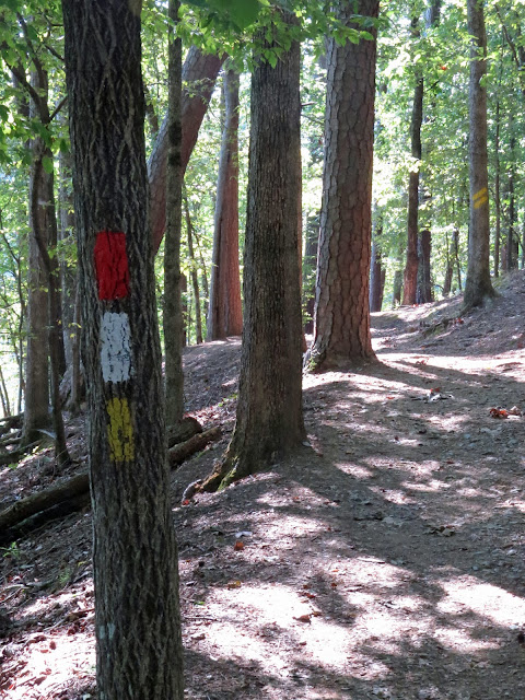
The three trails are fairly well paint-blazed,
but on the diminutive little bit of paper map they printed up in the brochure they obviously couldn't be bothered to use corresponding colors. In fact they actually confused things by miss-using red, which is the actual blaze for the Falls Branch trail but on the map is used to mark the Horseshoe Mountain trail.
Trail Actual Blaze Map Marking
Dam Mountain White Blue
Falls Branch Red Purple
Horseshoe Mountain Yellow Red
I suppose that's indicative of today'a pride of workmanship, or rather lack there of.
Oh well - let's just go hiking!
First up, since it looked like it might be the most exposed in terms of heat later in the day, (It was still August when I was there) was Horseshoe Mountain Trail.
A check of the topo clearly shows how this mountain got its name, and other than the approach and departure its namesake trail follows the horseshoe-shaped ridge-line of the mountain.
 |
| Yep. That's the trail there in the middle of this photo. |
According to my GPS track the published distances for the trails in this park are remarkably accurate, but because of the terrain up onto and down off of the mountain, as well as across the saddle at roughly the halfway mark, this trail hikes as a pretty long 3.5 miles.
The micro-clime of much of this trail is fairly arid, but along the way there are views down into the lushness below.
After wrapping that trail up and taking a short break at The Van, I took on the shorter Falls Branch trail.
Semantics are important here.
On the trailhead placard this trail is listed as the easiest of the three,
but they don't actually say it's easy.
The climb up towards and then back down from the saddle that must be crossed there in the center-left of my track requires some rock-scrambling,
switch-backs, and a few bridges and stairways. (one of the stairways is out there in the distance of this photo)
Twice I had to pause and step off the trail when people out in front of me (It's Friday afternoon and the park is starting to get busy) gave up and turned around to go back. (The dog member of one of these groups looked mighty relieved as he went by headed back towards the trailhead!)
Part of the problem here is that this sign, which sits at the end of the short spur leading in from the trailhead to the intersection of all three trails, is incomplete.
Again, lack of pride in workmanship.
You wouldn't know if relying on this sign, but both the Horseshoe Mountain and the Falls Branch trails also loop around off to the left at this point, and if you are only going as far as the actual falls, which seems to be the main draw here,
going left, where no arrows point, means following a segment of easy, flat trail
that sticks to the shoreline.
This is a publicity photo of the falls. I have no idea when it was taken.
This is my photo of the falls.
To be fair, there was a small trickle still running over the edge. Enough to entertain those kids down there at the bottom.
And over there on the other side of the falls is the beginning of the Dam Mountain trail marked by the double blaze.
But by this point it was getting well on into the afternoon. Too late in the day to be tackling that, the longest and most rugged of the three trails.
So I'll save that one for another day.
OK, I'm still 10 or so road hours from home, so where's the next stop on this trip going to be?!
To be honest, I was getting pretty far south by now and any further stops would be even farther south. With a heat index of 105 it wasn't exactly chill today, (August 19) and it wouldn't be any better tomorrow, so, with one more rest-area overnighter a couple hour farther down the road, I finished up the trip home the next next day with no additional hiking in between.
Quitting cold turkey is hard!


Accurate signage can make a hike so much more enjoyable. And that publicity photo will get people out there, but the reality of the trickle probably won't have them coming back. The trail along the lake and in the forest looks fun.
ReplyDeleteIt is a nice park, and seems to be popular, water in the falls or not. So turn up early because, though there's no managed entry into the park, there is limited parking at the trailhead and plenty of signage around stating that parking elsewhere for day-tripping is not allowed. This has the effect of limiting the crowds.
ReplyDeleteyou make me laugh, with your trail finding troubles. I hope i got it right, but the way you write about these troubles make me think you did have a wonderful time, yes? And i want to say, Way to go Arkansas!. just yesterday i listened to a scientist, who claimed that many little pieces of wilderness actually are better for the environment, then one big piece of the same size putting all the little pieces together. It made sense.
ReplyDeleteI like to think that my "trail finding troubles" come from a place of adventure and pushing the boundaries, but it could be that I'm just a bumbling fool.
DeleteI often think about one of my guys from back in my professional life. He ran my network group and one day the network had failed big time, so I checked in to see if he needed anything. He turned around from the keyboard he was clacking furiously away on with a big grin on his face, and with the building metaphorically burning down around his ears he exclaimed gleefully "I'm having a blast!"
I do believe that there is an order to the Universe and that order is maintained by balancing things out, a yin and yang philosophy if you will. And rather than live a flat life, never venturing far from that line of stasis, I would rather push the boundaries, reach out for the highs and accept the corresponding lows, (Although Mom has to hold her breath while reading about some of my adventures) so to answer your question, yep, I'm having a blast!
Yep, I'm having a blast!