
If my canopy, which normally sits over that bare spot beside the greenhouse, has been taken down

and strapped into The Van along with my camp-chair, (which is also my living-room chair) and it's August, that can only mean one thing.
It's time to head out for the family reunion up in Michigan.
At 0400 the morning of the 3rd I hit the road.
It was still dark, actual sunrise being a good three hours away. I don't usually have much need to drive in the dark anymore, but of the last 40 days, 37 of them have been 100 degrees or more, so, in an attempt to get some miles in before things heated up too much, I got a jump on the day thinking that if The Van got too heat-stressed along the way I could park through the worst of the day's heat and still keep to a reasonable schedule.

When leaving home, which is somewhere in or around that fuzzy pink blob, (Oh come on! You didn't honestly think I was going to pinpoint home did you!) and heading for Michigan my usual first-night layover is at the I-40 rest area just west of Forest City Arkansas.
That's about 12 road-hours from the house.
I often read bloggers that find 4 to 6 road-hours in a day to be their limit, and I understand that. Really I do. Hell, The Wife can just barely tolerate the 2 hour trip back from the city when we make our groceries run. When we hit the gate, which takes some time to open so we have to sit and wait for it, she's stripping her seat-belt off, gathering up her stuff, and it wouldn't surprise me if one day she got out, impatiently squeezed through the opening gate, and walked the rest of the way. (Well - actually it would since it's downhill on ungraded gravel which is really pushing the limits of what she can navigate on foot without breaking something!)
But for some reason I personally don't find long days behind the wheel all that uncomfortable or tiring. At least not yet. I fully expect that as I continue to age some limitations on that will start to appear, but for now - - -
With The Van behaving despite the heat and the sun still pretty high in the sky when I got to Forest City at around 1600, I decided that it was too early to stop, especially since I knew of another place a few hours further along, so I just rolled right on by.
The Missouri Welcome Center is at mile 30 on I-55. It's not the best place I know of to overnight, what with auto-parking being on the highway side of the facilities, (since I don't need the space I'm reluctant to take up a truck spot on the more sheltered side of the facilities because there always seems to be a shortage of them, truck-sized slots, and unlike a trucker just about to run out of hours who will get penalized if he keeps on driving, no one is tracking my hours and I can squeeze in just about anywhere) but the place is well-lit, secure, the facilities are fairly modern, and kept clean by an on-site crew. And really, all I need is a place where I can park for a few hours without bothering anybody.
This time I actually stopped, but it was still only 1900.
I got out, peed, walked out a few of the kinks on the little loop around the facilities, looked up at the sun, figured it was still a couple hours above the horizon and there'd be nearly another hour of twilight after that. So, being boss and head bottle washer of this circus, I determined that I wasn't feeling particularly knackered yet, and climbed back behind the wheel.
Now I had my sights set on the Marion Walmart yet a few more hours up the road where I've also overnighted before.
I pulled into the Walmart parking lot during the last of the light and this time, after putting in 16 hours on the road, and being a little hungry, (I usually don't eat when driving in order to avoid the drowsy factor - not to mention that whole belly-flopping-over-the-belt issue) I stayed stopped this time.

Waking up the next morning in the parking lot of the Marion Walmart I realize I'm about 6 hours ahead of my normal schedule so, in order to use those six hours productively, I set my sights on Turkey Run State Park in Indiana.
I can't tell you, mostly because I don't keep track, how many times I've driven right by the entrance, but so far had never stopped.
Now I know that Turkey Run may not seem like it's on the route from Central Texas to Michigan, but having a mild aversion to cities, I haven't driven through Indianapolis, the more obvious route, in many - many - years.
I used to take I-70 across Indiana to about halfway between Terre Haute and Indianapolis then turn north on 231 and start skirting my way around the city. But one year a chunk of I-70, including at least one key bridge, just east of Terre Haute went under construction and it was a friggin mess! So I started wandering north out of Terre Haute instead to avoid the backups and found I liked this even more circuitous route, which passes right by the entrance to Turkey Run State Park, even better so I kinda abandoned 231 except for a very short chunk of it in Crawfordsville.
But with an extra 6 hours in the bank I decided today was a good day to stick my nose into the usually bypassed state park and check it out.
Although one state away from where I spent the night the park is a relatively short 4 hour drive from Marion so it wasn't yet 10 when I paid my $9 at the entrance and drove on in. ($7 for state residents.)

At 2400 acres this is a fairly decent sized park that really has a split personality.

First thing I did was poke my head into the Nature Center.
It's small but seemed to do a good job of getting the salient points about the area across, including several interactive displays aimed at the kid in all of us.
I say seems because, despite what it looks like in the photo, there were just a few too many people wandering around as if COVID had never happened, so I didn't stay in there very long.
OK, OK, so it's possible I'm slightly overusing COVID as an excuse to avoid people, but it fits so well into my preferred lifestyle!

As I was
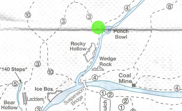
Trail 3, listed as Very Rugged looked pretty interesting but there was a also a red-lettered notice just above the map dispenser noting that a section of Trail 3 was closed due to a downed tree.

On top of that, there were enough people around that when I saw that a section of this trail is called Ladders (they really are ladders used to negotiate a particularly challenging series of rock walls and waterfalls) I had visions of Angel's Landing in Zion National Park or the Guadalupe Peak trail in Guadalupe National Park. These are places that are consistently jammed nuts-to-butts with sheep-like herds of people that think it's some sort of badge of honor to bag a feature like that even though thousands upon thousands do it every year. (Hell, you have to hope to win a lottery at Angel's landing just to secure one of the nuts-to-butts entry passes required to hike the trail!)
Not that I'm against sheep-like herds of people! By all means, flock to these "special" spots and leave the rest of the wilderness for those of us that would rather not be smelling the farts of the hiker in front of us.


But since many of the trails here, including Trail 4, are on the other side of Sugar Creek I first had to get across the suspension bridge down there behind the Nature Center.


the tower supporting the south end of the bridge.


which carries you (well, you don't get carried, you have to walk!) across Sugar Creek.


But eventually I made it far enough up that section of Trail 3 to find the beginning of Trail 4 right there at the U-turn at the north end of my hike.


After a little more than a half mile of gentle woods-hiking the trail pops out into a clearing

where the Lusk house sits.


Its concrete replacement is just up stream, and just beyond that is the site of the Salmon Lusk Mill that was the primary driver of the development in the area.


From here back to the suspension bridge the trail was back to following more rugged terrain alongside Sugar Creek.

and before getting back to where I started I came across

this small coal mine perilously close to the creek's bank. (you know - flood wise.)
The mine was too small to be a commercial venture so was used as sort of a private energy-source to keep the Lusk household running instead.

The trail guide lists Trail 4 as being 2 miles long. After I added in the trip down to and back up from the suspension bridge, the bit of Trail 3 you have to take to get to the northern terminus of Trail 4, and my usual additional bit of wanderings along the way, the GPS said I had hiked a quarter mile less than 4 miles.
By the time I made my way back across the suspension bridge, (Now I know how to find the southern end of Trail 4 - so easy it was embarrassing!) back to The Van, had a snack, and relaxed a little, I had just about enough time to get to my next overnight spot before dark.
But remember several posts ago when I said I made three stops along the way while getting to and from the reunion? Two old that I'd been to before and two new that I hadn't?
Well to make the math work you should know that I stopped here at Turkey creek again on my way back, making this place a twofer. Once new and once old.
So we'll be back here again in a couple posts exploring other areas of the park.
Island Musings -- listed on the right of mine -- caught Covid this week from their grandchildren. They'd had all the shots too.
ReplyDeleteYep. We can pretend otherwise all we want, but it's still out there.
DeleteAnonymous!! Never!
ReplyDeleteWhat do you mean never?! Anonymous is my preffered state. (Even if I can't spell it - - )
DeleteTo each their own. I just maintain myself as a moving target.
ReplyDeleteInteresting...the regional differences in waterway designations -- that "creek" looks similar to the Rio Grande.
The wetter the country the bigger the water before it's called a river!
Delete