Sunday, August 21, 2016

{Iowa}


Personally I think there's a strong argument for officially including braces around Iowa like I did in the title of this post.

After all, in reality that's exactly what nature has done.

Unlike the arbitrary, and completely man-made, splitting of Utah, Colorado, New Mexico and Arizona by the convergence of a dead straight north/south line with an equally straight east/west line, despite the fact that the natural, and very real, east to west boundary of the San Juan river passes only 3500 feet away from the imaginary Four Corners.

Unlike Four Corners, which can only be found with the help of markers placed by others, when you come to Iowa, whether from east or west, you know without a doubt that you've crossed from one territory to another. There's a clear demarcation between one place and another. Here no one came along, scratched a line on an undistinguished piece of  ground and declared this side is one thing, and this side is something else.

The Mississippi looking from Iowa across into Illinois

Here you know were you stand becasue nature defines and contains Iowa's longitudinal borders with the Mississippi on one side and the Missouri on the other. Very neat, tidy, and logical. And somehow comforting.

On the Lincoln Highway leaving Iowa for Nebraska

I hear Iowa getting a bad rap on occasion. Things like; Iowa, it's not as depressing as Idaho, Come for the corn, leave because of the corn; Iowa, gateway to Illinois, or, one I hear a lot, Iowa stands for Idiots Out Wandering Around  (Though that last one inevitably comes from Missourians, the only state where I've ever seen billboards encouraging people to turn in their neighbor's meth labs. . .)

I, myself found Iowa to be a pleasant place. Easy on the eye, easy to drive, and plenty of interesting places if you know where to look for them. On a slight detour from my Lincoln Highway route, which is mostly small towns, I even managed to drive through the heart of Iowa City, home of the University of Iowa, and was impressed with how clean and neat this place was, despite my aversion to cities.

And there has to be a reason that RAGBRAI is in Iowa and nowhere else.


Don't know what that is?? I didn't either until I was there. Without going into what all the letters stand for, RAGBRAI is the largest bike touring event in the world and is held entirely within the borders of Iowa. Since 1973 this tour has crossed the state from one side to the other, with the route changing every year to make sure the entire state is included.

More than 13,000 riders participate in the week-long event, including the 30 member Team Gourmet which travels with three chefs and, as you can imagine, eats well for the 7 day ride. (There's a waiting list to join the team and you have to be recommended by one of the senior members, so don't go grabbing up your finest silverware and bike shorts expecting to snag a week's worth of 5 course dinners!)

Oh dude!! No helmet and a bald head to boot!  Not a choice I would make. . .

So anyway, go ahead and throw all the derogatory one-liners you can come up with at me, Iowa is still definitely a place I'll go back to.


Friday, August 19, 2016

When Tires Attack!!


Sounds a bit like the title of a horror story doesn't it. And for a brief moment there it was.

Around here August is when we start thinking about the fall garden. It's time to get the tomato seeds started and this is a perfect time to get many herbs, especially the Mediterranean herbs, going. Plenty hot enough for the seeds to germinate but the heat will soon be easing up so the young plants aren't too stressed.


We have a little wagon that comes in handy for mixing small batches of growing medium, but when I drug it out this morning the off-side rear tire was completely flat.

No big deal, these small tires typicality don't hold air all that well anyway, so I'll just give it a shot of fresh stuff.


Well that didn't work out so well. . .


About a second and a half into my usual two second shot of air there was an almighty BANG, and that was the last thing I heard for a while. . . which can't be good for my already raging tinnitus.


Fortunately, other than temporary deafness and underwear, the only casualty was a couple burns where bits of rubber shrapnel rocketed across my hand.

Well - there was the ruined tire and tube as well. . .


 but those can be replaced.


After a shot of air to check that my spare tube wasn't leaky; because finding that out afterwards would suck; I pulled the valve core and stuffed the tube into the replacement tire.


A splash of soapy water to ease reassembling the hub


Another shot of air; though I have to admit I was a little gun-shy about this step. . .


And we were back in action!!

Now if only I could remember why I needed the wagon in the first place. . .


Thursday, August 18, 2016

The Kate Shelley High Bridge


Before US30 existed the Lincoln Highway connected Boone Iowa to the rest of the world.

Before the Lincoln Highway existed, the Chicago and North Western Railway connected Boone to the rest of the world.

And to follow that connection west in the early years of the 1900's, you had to cross the Boone Viaduct, more commonly known as the Kate Shelley High Bridge in honor of a teenage girl that in 1881 braved a storm, and the dark, to cross the bridge (an earlier version on a different alignment) on foot in order to stop the passenger train and warn them that the next bridge, the one over Honey Creek, was out.

When it was built in 1901, 186 ft above the Des Moines River and 2685 ft long, the steel bridge was one of the highest and longest double-tracked bridges in the country.

That original bridge was in use for over 100 years, though sometimes reduced to 25MPH and a single train at a time despite the double-tracking, until a new concrete bridge was put into service in 2009.


Google Earth view of the two bridges side by side crossing the Des Moines River

The new bridge is a few feet higher than the original and a little longer, but nowadays there are higher and longer bridges around so it holds no records. But it is an operational improvement! The new bridge is also double tracked, but even wider than the old bridge for increased track spacing, and is rated for speeds up to 70 MPH with trains crossing both ways at the same time!

As I left Boone, heading west on E31, the original the Lincoln Highway, crossing the Des Moines River on a narrow but sturdy bridge with an abrupt hump in the middle to accommodate boats, there was little traffic. Not surprising since US30 is only a couple thousand feet to the south. But I had a destination in mind that required locating a gravel road with the grandiose name of J Avenue.

As soon as I turned north onto J the world behind me disappeared. This was one of the dustiest collections of roads of the trip!  Knowing it was useless, but trying anyway, I slowed to a crawl at each of the four, well spaced houses along the road, hoping to spare them my personally created dust storm.

My destination was that Kate Shelley High Bridge and these things are often difficult to get to, so I persevered, rattling on and raising a rooster-tail any testosterone driven speed-boater would have been proud of, except mine was a little drier. . .


Along the way I came to this somewhat rickety looking bridge (It actually looks better in the photo than it did in person. Bummer!) that popped up over the railroad tracks. I hadn't seen the tracks yet either, but take my word for it, they're down there in the weeds somewhere.

Google Earth view of the rickety bridge, but I came from the left and turned on the road heading off the bottom of the image so didn't partake of the bridge's thrills.

The small white sign posted right there on the brink of disaster promised the bridge would survive a load slightly more than twice my weight despite appearances to the contrary. I chose not to test that claim.

The Road Closed Ahead sign was a little worrisome too, but only a little since I was supposed to turn here and not actually cross that bridge anyway.


You might have to look hard, but there's a train out there!
But as soon as I made the turn I had another problem.


Here I was, carefully picking my way down to a railroad bridge, and there goes a train, heading for that very bridge!!  If you remember, I once had a chance to visit the Tulip Trestle in Indiana, but never did actually get to see a train up there.

Was I going to miss my chance again; by minutes this time??!!


So the race was on!!


I rattled down 208th street as fast as I could stand, (Sorry, but that just sounds wrong! Gravel roads should be named humble things things like Henderson Lane or Honey Creek Cuttoff, not number streets or lettered avenues.) dust be damned as I passed the one and only house out there.

At the T intersection I skidded into a left turn and shortly after that dropped over the edge on my way down towards the river and under the bridge.


They might be long distance, but by golly I was going to get at least some shots of a train on the bridge!!


From this angle you'd swear the train is on the old steel trestle, but not really, it's over there on the slightly higher, and much newer, like over 100 years newer, concrete bridge behind it.

I got this and the next 3 bridge shots after backing The Van onto solid ground once again and jumping out to run up the road on foot, which was faster than backing up to a spot wide enough to turn around.

With the train still rolling by overhead - but for how long? - I slipped under the bridge and tried to make for the river to get the money shot. But the closer I got to the river the worse the road got, and in my myopic obsession to get the shot I pushed right on past smart and reasonable and well into dumb and stupid before realizing what was going on.

Sure I have some pretty aggressive tires on the rear of The Van for roads like this, but there is a limit, and not too far behind where I'm standing in the photo above, which I took only after getting The Van back on solid ground, the road was basically gone!

For those not distracted by the train overhead there were plenty of signs of recent flooding. Signs I didn't really take note of until the road gently fell out from under me and I was suddenly driving in drifts of loose sand peppered with tortured debris!
 
Doing my Oh Shit! I've screwed the pooch now! version of rapid Lamaze breathing, I let The Van roll to a stop, something it was more than willing to do in the deep sand hiding a couple of jarring holes, though at an angle that brought to mind a bird with a broken wing.  Then, promising all sorts of things to any Deity that might be listening, (Oh crap! Did I just give my daughter away??) shifted into reverse and gingerly feathered the accelerator.


Man, am I glad I have those BFGoodrich Baja Champion All Terrain T/A's on the rear!! They're a little noisier at highway speeds, and they won't last as many miles as more normally shod tires, but I could have been in serious trouble there along the Des Moines River with wimpy stock street tires. (Back on solid gravel again! A quick check. Whew!! I didn't pee myself!  Now, where's that crowbar to pry my fingers off the steering wheel?)


It's always disappointing that in photos things,like this road, don't look as steep or rough as they really are.

Oh, and see that sign there on the left?? In my distracted state I didn't, but the other side clearly warns of Road Closed Ahead. Sure am glad no one will ever know what a dumbass stunt I pulled. . .


As for missing out on the train?  Well turns out I didn't need to worry about that. It was a very long train and going far less than the 70MPH speed limit, so I had plenty of time to capture it waddling and squealing its way across the bridge.


And those Road Closed Ahead signs?? You know, besides the road not actually being there.


DOT photo
It seems that the Wagon Wheel bridge fell into the river. This was an auto bridge just upriver from the railroad bridges which I think thought might make  a great photo-vantage point.

Since they're only going to remove enough wreckage to open the river back up to boat and float traffic and have no plans on actually replacing the bridge, I figured it wasn't worth waiting around for the next train. . .


Tuesday, August 16, 2016

Tama and the Lincoln Highway Bridge


When the creation of the Lincoln Highway was announced in 1913, officials of the Iowa town of Tama got excited. When it was confirmed the route for this new experiment in overland-road travel was going right through their town they jumped into action and in 1915 built a bridge just for the new highway.


Not necessarily very exciting news is it? I mean there was going to be hundreds of bridges along the Lincoln Highway. and the Tama bridge would only span about 22 feet, not even as long as its mandated 24 foot width, to carry cars over the mundanely named Mud Creek.


But the city fathers thought of that and they made sure this was the only bridge of it's kind in the country by designing unique guard rails that spell out LINCOLN HIGHWAY  in concrete.


The green line above (Ignore the yellow, and even heavy white lines, they did not exist in 1915.) is roughly the original alignment of the Lincoln Highway. The black arrow points to where the Lincoln Bridge carried the highway across Mud Creek

Just 11 years later the yellow line was the new routing for the Lincoln Highway

Unfortunately, it's not in people's nature to leave things alone (How else to you expect bureaucrats to justify their publicly paid salaries if they aren't constantly meddling in order to look busy??) and only 11 years after it was commissioned, the Lincoln Highway was rerouted through Tama, and the new routing was just enough to leave the Lincoln Bridge - well - high and dry.

But at least the highway was still going right through the heart of town and business was good.


Eventually though US30 came along (The blue line) and traveler-dependent business's had to move from the town center out to the new-fangled highway.


But wait!! Those bureaucrats weren't done spending public money yet!!

Apparently the thought of through traffic having to deal with the handful of traffic lights in town was unacceptable, and a high-speed bypass was built in 2014. (Some of that Economic Incentive money?) Now if you lean over to change the radio station at just the wrong moment you might not even know you just went by Tama!

I have my own thoughts of whether it was worth the $82 million it cost us taxpayers (US highway = US dollars = our federal income taxes.) to divert the estimated 7500 vehicles a day right around the businesses that depended on them, but now most of the stranded businesses can not afford to move to the limited real-estate at one of the three access points along the new bypass because national chains are buying up that land at - well - national chain prices.

Apparently business at the King Tower restaurant, open on the Lincoln Highway since 1937, has been cut in half since the bypass opened and even the auto-parts store is noticing a drop in sales of things like windshield wipers and de-icer.


But the town has stood firm and made sure that this unique bridge is being preserved none-the-less, with maintenance when needed, and an annual Lincoln Highway Bridge Festival to remind people that the historical, even though bypassed, is still important.


When the highway was realigned the first time, in 1926, the town grabbed up the little triangle of land  that was formed by the new routing there at the east end of the bridge


and created a pocket-park which provides parking, a little information for those interested in history and a place to just stop for a minute or two.


And today you can still drive across this original piece of the Lincoln Highway


and follow the banners, paid for by the town itself, to trace the original route of the landmark highway within it's streets. (Seven new banners bought in 2011 to replace the old, faded banners, at a cost of $153 each for a total of $1071 plus shipping.)

Because a town of less than 3000 believes in it's heritage, I was able to drive that old route


and imagine what it was like back in the days when travel by road was a real adventure.


But Tama is small and eventually I came out the other side and back to today.


Monday, August 15, 2016

The Microwave sparks out:


Like I did with the TV, for the past few trips I have also deliberately avoided using the microwave just to judge how vital it really was to my health and well-being; the result being that it too got the heave-ho before I left on this last trip.

Unlike the TV, which operated on 12V, the micro could only be used when hooked to shore power. Oh, in theory I could run the little 900 watt unit off the inverter, but it always sounded weird when I did, so that was something I didn't do very much; up until the inverter died, then I didn't do it anymore at all. . .

By the way, the inverter, the really expensive 2000 watt inverter/charger (40 amps of charge current.) was past it's warranty period by the time it quit but probably had not much more than an hour or two of actual invert time on it. What a waste of money that turned out to be!! (My decision to install it in the first place so nobody to blame but me. . .)


Where the Microwave used to be
 And let me tell you, for a little 900 watt thing that micro was heavier than I expected!

I haven't bothered weighing it (Yes, I carefully wrapped and stored both the TV and Micro in case I ever decide to pass The Van on to someone else.) but I doubt I can jam that much weight in supplies into the three very useful baskets that now reside where the micro used to be.


The baskets are kept in place with a couple of $3 spring-style curtain rods. Fortunately the smallest rod at the shortest setting just fit.


As a substitute for the microwave I've found that those little disposable loaf pans loaded up with whatever and dropped into a half inch of water in the bottom of my Dutch Oven work just fine. Sure it might take just a little longer, but only a little, and the cleanup is easy.


OK, next post - back to the trip

Thursday, August 11, 2016

TV? I Don't Need No Stinkin' TV!


For the previous couple of trips in The Van I have deliberately avoided using the TV. Which turned out to be easy to the point of not even thinking about it.


It's not that I'm one of those TV-free snobs, quite the contrary. In fact cable TV hookup used to be high on my list when scouring the Trailer Life Campgound Guide for my next stopping place. But I think that Directv and the DVR have spoiled me beyond repair.

With Directv's onscreen guide we can see programing out 10 or 11 days ahead (Not like the cable guide's hour and half's worth of scheduling that you have to wait on as it scrolls slowly up the screen and for God's sake don't take a drink or look down at your sandwich or glance at your ringing phone or you'll miss it and have to wait all over again for it to come back around,!!!) and with the DVR we can choose to record individual shows or entire series, we can record reruns or only first-runs, we can record up to 5 shows at the same time and if we select more than that the DVR will automatically look for later airings of anything we overbooked.

So for the past 10 years or so we've been watching what we want when we want, skipping right over the commercials along the way.

If, for some reason we do watch something 'realtime', we don't; not really. We punch the pause button and find something else to do for a half hour or so. that way we can still skip over the commercials.


Where the nearly 15 lb. TV used to be. I haven't gotten around to removing the mount base because I would have to pull the fridge out to get to the bottom bolt, and it's just not worth that much effort.
I'm not saying this as an add for Directv, but rather to point out that I'm spoiled and trying to watch cable or over-the-air TV nowadays is just frustrating and ultimately an unsatisfying waste of time. So before I set off on this trip I removed the TV from The Van.

I've got a select few boxed DVD sets stored in the pantry that I can play through my laptop when I want some screen-time
Now don't you TVphiles out there go feeling sorry for me, because I do watch shows while on the road. You see, I have a select collection of shows on DVD and when I feel the urge, I play an episode or two on my laptop. Again, what I want, when I want, how I want.


Wednesday, August 10, 2016

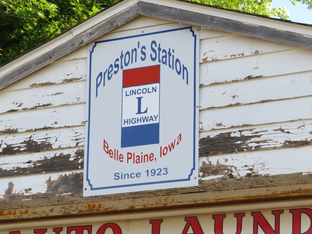
Preston's Station


The Lincoln Highway has, over the years, been moved, often more than once.

Back in 1913 at the time when the Lincoln Highway Association (LHA) first formed with the objective of creating a true coast to coast highway, all that was available was a collection of here-to-for dissociated roads in various states of travel-worthiness, and when the LHA started stringing those together to form the transcontinental route, the Lincoln Highway ended up cutting right through the Iowa town of Belle Plaine.


The exact route of the Lincoln Highway as it snaked through town changed three different times, but then eventually US30 was conceived of and built, and the Lincoln Highway officially moved nearly five miles north of town; forever.


But if you're willing to take a detour, you can still find Preston's Station sitting there right where it was when the road out front was the Lincoln Highway.


This tiny building was first built in 1912 right on, as it turned out, the original alignment of the Lincoln Highway, up there on 21st street, presumably all the way up there because it was clear of all but the worst mischief the Iowa River to the south of town might get up to.


In 1923 George Preston bought the building for $100, renamed it, built a business in it, and when the highway moved to 13th street,  he moved the building right along with it, then built a three room motel beside the station and a home behind it.

Apparently the river had been behaving for a while now and bringing the highway closer to the heart of town was deemed safe. Remember these were the days when highways were considered good things, good for business, good for growth, and good for civic pride, not the evil necessities of today, so having it right in town was desirable.


The building is still sitting there on the corner of 13th Street (Also known as SR 21) and 4th.

Over the years it's been plastered over with all manner of old signs and some might think that's what's holding it up now. And maybe they're right, but not in the way they think, or at least not in the way I'd like to think.

I'd like to think it's not so much the painted metal, the physical structure, of all those signs that provides the binding that keeps this, and many other places like it, standing, but rather the memories and dreams behind each and every one of those bits of wood and metal and paint, that it's the determination and sentiment with which the  nails holding them in place were driven, that keeps Preston's Station standing.

After all, this is not just an old building, or even just the marker of an era. It's a life's work. It's the raising of a family, and all the laughter and fear and joy and sorrow and sweat and satisfaction that goes along with that. It's kids bounding in the door after school and the selling of a needed service or goods to neighbors. It's the despair of a traveler with a broken engine, or the peace of mind of a full tank for the next stretch of highway.

There's stories, antecedents, whole books, lurking there in a century's worth of life's echos that have soaked into the boards and beams and rafters of this place, and I'd like to think that's what's actually holding it up.


In fact, the highway may have moved on, but up until his death in 1993 George could often be found there at the station, telling tales of the old days.


His granddaughter owns the station now and hopes to leave it as is, if not restore it.

I kind of  hope this piece of history sticks around until I'm history.