Apr 15 2014

That might be because I set an alarm to get up in the wee hours to catch the blood moon. That's where the earth eclipses the moon and the earth's atmosphere bends the red light waves from the sun around, like a big halo, to shine on the moon. Now that's not something that happens everyday! I think we have one more chance this year, one next, then won't have anymore for something like 32 years. There are plenty of better photos of this phenomenon but this is the best I got with my tiny little portable tripod that shakes when an insect flies by. At least the sky was clear but unfortunately the good photo wasn't timed just right so there's quite a bit of yellow light hitting the moon as well as red. I'm not enough of an astronomer to know what that other bright spot is. I don't even know if it is a planet or star.
 |
| Breakfast right out of the skillet |
 |
| Saddled up and ready to hit the trail |
You get there by crossing the river at Trammel Crossing, which was named for one of the early European settlers and not for the impediment it can be when the water is high. Years ago
I crossed the river, make the hike and re-crossed, only to come back a couple days later to
find the banks ravaged by a flash flood that raised the water level by about 20
feet, and around here it can do that in as little as 5 minutes! If you’re smart you
carefully check the weather before making that hike!
 |
| But first I have to get across the river |
Way back in the far corner of this orphaned section of the
park is the small cemetery. Today it looks like it originally sat under a massive,
live oak but the cemetery was last used well over a century ago so the oak is probably a late comer. Now days the remains of the cemetery still sit in a nice little glade but the cedars
have filled in (As I type this while sitting at the picnic table a hummingbird
just flew in the open side door of the van checking for juicy flowers!) but it’s
still a pleasant little spot. Years ago I asked the park staff about the cemetery
and at the time couldn’t find anyone that knew anything about it, but now the park system has compiled a nice little history of the area.
Just about where the trail returns to the bluffs above the
river near the northern border of the park a coyote casually trotted off into the brush, not ready to hang around
but not in any particular rush either; but still too fast to catch him with the camera.
 |
| The USB memory stick gives an idea of how tiny these little guys are |
 There’s a little sliver of the park right here poking up to
the north which is trapped between the river on the west and a private ranch to
the east. Most of that little sliver is limestone bluffs 200 feet above the river and, in little
glimpses between the trees which insist on clinging to the steepening slopes, slopes
which make the intrepid hiker step with care lest he take that long, bouncing
slid down to the water, there are views of the country to the west and a little
bit of the river down below. It might be my imagination but I think the river
multiplies gravity right along here and is doing its best to suck anything up
on the bluffs, including that intrepid hiker, down into its clutches!
There’s a little sliver of the park right here poking up to
the north which is trapped between the river on the west and a private ranch to
the east. Most of that little sliver is limestone bluffs 200 feet above the river and, in little
glimpses between the trees which insist on clinging to the steepening slopes, slopes
which make the intrepid hiker step with care lest he take that long, bouncing
slid down to the water, there are views of the country to the west and a little
bit of the river down below. It might be my imagination but I think the river
multiplies gravity right along here and is doing its best to suck anything up
on the bluffs, including that intrepid hiker, down into its clutches! |
| The trail follows an old wagon road through what used to be mostly grasslands before overgrazing let the cedars start taking over. |
 |
| The land briefly supported a small community, of which about the only thing left is traces of a cemetery. |
 |
| The fencing was added around 1930 by the then current owners to protect the grave sites from livestock even though they knew nothing about who was buried here. |
 |
| Not all the graves were fenced and today only a handful are obvious. |
 |
| The headstones have all weathered to the point of total anonymity |
 |
| And this Live Oak might not have even been a sapling at the time of the burials. |
 |
| The park boundary is near the cemetery and this view over the fence gives a hint of what the land might have looked like after the long lush grasses were grazed short but before the cedars took over. |
 |
| As I was positioning myself to get a shot of this heart-shaped Prickly Pear pad I managed to back into another and had to pull a couple spines out of my right calf! |
 |
| The views to the west from the bluffs above the river |


 |
| And down there, a loongg two hundred feet down, is the river |
 |
| While I was precariously partaking of the perilous views this guy decided to drop in and stick close, just in case! Notice how even he has to brace himself against the insidious gravity. |
 |
| Rocks above, rocks below, rocks under my feet; and just last night I watched a DVD lecture by a geologist about how geological mass wasting works, which is basically that gravity, water and wind eventually make everything fall down! |
 |
| But these guys took my mind off the abyss |
 |
| On my way back to the trail-head I detoured to the highest point in the area where these yucca were hanging out. |
 |
| Sharp |
 |
| and tall |
 |
| Once in a while I came across another scourge of the grasslands fighting for space with the cedar, the delicately green mesquite |

 |
| Can you find the little lizard hiding in here? Me either but I swear he was there somewhere. |
 |
| And then it was time to cross the river again |
After a few hours break during which I whittled away at my magazine stack, I took off on a late afternoon ramble down and around the Twin Falls nature trail.

 This would be more of a nature
trail if there were placards and/or brochures explaining some of the plants and
geology but it does give a close-up and personal experience with the limestone
ledges that rim every waterway around here as well as a view, of sorts, of the
twin falls. Ever since I started coming here in the 80’s the area around the base of the Twin Falls has been closed so the area
can recover from overuse. I guess the recovery is slow since you still are only
allowed to look from an approved platform high above the pool, the one the Regal Creek
cascades down into. Today things have grown up enough that only one of the twin falls is visible from the
platform but even from a distance you can get a sense of the crystal clear
water and deep limestone pool below the falls.
This would be more of a nature
trail if there were placards and/or brochures explaining some of the plants and
geology but it does give a close-up and personal experience with the limestone
ledges that rim every waterway around here as well as a view, of sorts, of the
twin falls. Ever since I started coming here in the 80’s the area around the base of the Twin Falls has been closed so the area
can recover from overuse. I guess the recovery is slow since you still are only
allowed to look from an approved platform high above the pool, the one the Regal Creek
cascades down into. Today things have grown up enough that only one of the twin falls is visible from the
platform but even from a distance you can get a sense of the crystal clear
water and deep limestone pool below the falls.
 |
| Now days you can only see one of the twin falls dropping into the pool below |
 |
| And it takes binoculars or a good zoom lens to see how deep and clear the pool is |
 |
| Here I am working my way down along the Pedernales River, crossing Regal Creek right were it flows into the main river, |
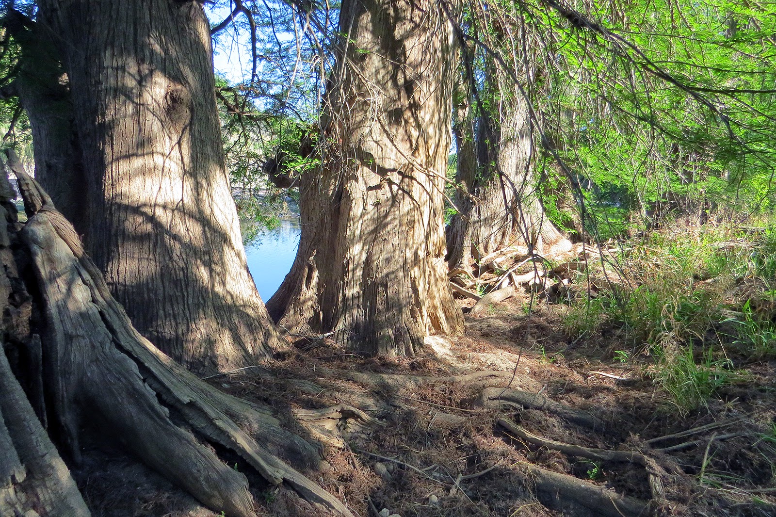 |
| scrambling past some of battered long-time river-side inhabitants, looking for a shortcut over to Wolf Mountain trail. |
 |
| But that didn't work out as planned. The limestone bluffs towered above me the whole way, this section reminding me of the Gila Cliffs cave dwellings, and I didn't think it was a good idea to try climbing my way up! |
 |
| So it was back to camp and my crock-pot dinner |
 |
| Which didn't last very long!! |
The trail markings along here are much better now than they have been
in the past though. This area is adjacent to the campground with some campsites
backing up onto it so has always been slightly trampled. Many years ago I
missed the turn the approved trail takes and followed one of those ‘tramples’
until it petered out. This was long before the days of GPS so I did some bushwhacking,
squeezing my way through the thin but closely spaced trunks of the early-growth woods that were there at the
time until I came across a power line that I was able to follow back towards
the campground.
Today the only bushwhacking I had to do was by design.
I was looking for a shortcut across the lower ends of Regal and Bee Creeks so I
could get onto the Wolf Mountain trail tomorrow morning from the campground.
That plan didn’t work out so well.
After 2 more miles of hiking to add to the 6 from this morning I made it back to the campsite and dinner.
That plan didn’t work out so well.
After 2 more miles of hiking to add to the 6 from this morning I made it back to the campsite and dinner.
No comments:
Post a Comment