In talking with some cousins that live near Chicago it turns out I’ve been more places in Illinois than
they have despite them also being campers. Admittedly, left to my own devices that probably wouldn’t have been the case,
but since Illinois is on the track from Texas to Michigan – well, here I am.
Not that it’s all bad. I’ve said before that southern
Illinois is different enough from the rest of the state that it probably should
have been given its own identity.

This time, as I was passing through, I decided to focus on
the Tunnel Hill State Trail. right down there in the southern tip of the state.

It’s a common story anymore, the abandonment of railroads, but the good news is this 45 mile hike/bike
trail, the Tunnel Hill State Trail, exists because of one of those abandoned railroads.

Headquarters for the trail is in Vienna along the eastern
edge of the city park a few blocks east of the intersection of US-45 and
SR-146, or not quite a mile west of I-24 exit 16 on SR-146.

The whole place, the city park and trail headquarters, is very well kept and two mornings in a
row I ran into someone tending the planters and gardens out front of the headquarters
building, but as the National Forest Ranger warned me, the building itself is open on an erratic
schedule. One that kept it closed every time I was there over the next few
days. Unfortunately this is something that, in this day and age of very limited budgets, can be counted on more often than not.

Another thing that can be counted on with most rails-to-trails
locations is that the maps are not so great. Maybe that’s because it’s hard to
get lost on this type of trail, but there are other things maps can be good for
too, such as identifying significant historical points along the trail.
The paper map in the official state brochure, which I had to
pick up at the nearby Shawnee National Forest Headquarters because the State
Trail headquarters was never open, was better than

The TrailLink map

but in terms of trail-side history – you know, the good
stuff – the kiosk-map alongside the headquarters and at some of the major trail access points was the best,
although the only way to take it along with me was in photos, and frankly, get that tiny little screen on the camera into the sun and it sure is hard on my aging eyes.

Anyway, here I am setting out on my first segment of this
trail, from Vienna to Karnak at the southern end of the trail.
Normally I would want to do the uphill segment on the way
out so I have a downhill for the return trip, but since there’s only a 30’
difference in elevation in the 13 miles from Vienna to Karnak it didn’t really
make any difference which way I rode.

Here is the first of many bridges encountered along the way, because there's a lot of water around here! Note that the planks are laid on a diagonal. Much smoother riding than if they are placed perpendicular. (Something the builders of the Caprocks Trailway didn't think of!)

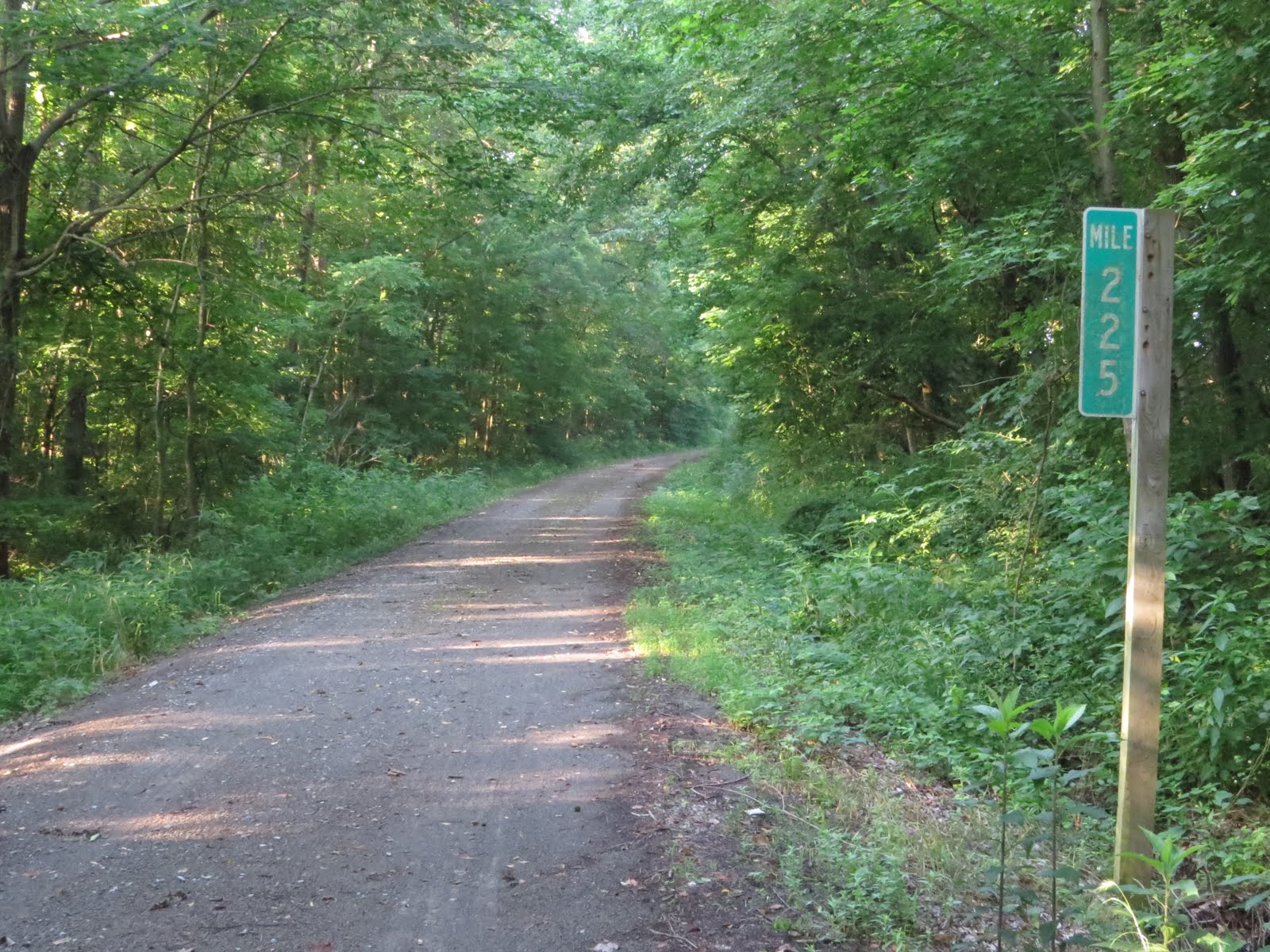
Here I am at the first mile-marker, mile-mark 225 (The
mile-markers are from the days of the railroad which began its journey at Vincennes
Indiana)

And here I am back at the trailhead. . . The Van is over there left of center in
the photo and I'm heading back there because I had a brain-fart this morning and left without sticking a
book in my pocket. And everybody knows one should never go anywhere without
a book in their pocket! (Cargo pants rule!!)

Here I am approaching that first bridge for the second time,
Aaannnd – back to
mile marker 225.
Maybe now we can get this show on the road, so to speak. . .

Not too far south of Vienna the railroad and US-45 cross,
though I doubt, based on the limited clearances available, that this was the
original crossing. It's probably just barely wide enough, but this thing is way too short for stuffing trains
through!
Just northwest of here, a few feet to the right in the
photo, used to be the “town” of Bender which never consisted of any more than a single building (Hence the air-quotes around town) used by the railroad as both offices and
housing. I can only speculate that the railroad chose this remote location because it wanted to keep its employees away from the temptations of the 'big city'. Vienna isn't all that far from here via railroad car, or today, bike on the trail, but would have been a fair walk for just a quick booze-up in town.

Next stop along the way is Foreman.
In the 1870’s there was a large lumber mill plus the supporting town that grew around it here. But eventually the timber gave out

and the swamps became the predominant feature. But then in
1910 the Chicago Burlington and Quincy RR came through (Now the BNSF and we'll get there in a moment.) and revived things
again.

Fortunately the revival was short-lived. Fortunatly because a tornado
came through the now nearly deserted town in 1957 and permanently wiped it out of existence.
Now all that’s left is the crossing of Heron Pond Lane, a narrow gravel road
that, just west of the trail, climbs up onto a small ridge where it dead-ends
less than a half-mile further on in the driveway of a small farm out in the
Little Black Slough State Nature Area.
I knew this because I had done some research ahead of time, but I suspect that most riders don't bother and just get out here and pedal. I know it costs money, but I still think it’s really important to
have this sort of information posted out there on the trail because without that sort of effort it pretty much consigns all these little bits of
history, these stories of development, industry, and individual lives
remarkable not for some flash of glory, but rather for the hope, hard work, and
determined persistence that are the underpinnings of success, to the permanent trash-bin.
Or maybe I’m just a dreamer. . .

Anyway, when it comes to history little things like finding
this original bridge give me a tingle there in my secret place.
OK, so this is a partially original bridge since the timber approaches
have been torn out and replaced but the original through plate-girder bridge
section is still there,

even though, with its literal tons of steel plate (Lots of scrap
value there!) and countless rivets, each one individually heated, placed and
set (hammered over), it’s much more substantial
than required for getting foot-traffic over this slough.

As implied by that small farm up Heron Pond Lane, not all
the land around here is swamp and occasionally I got a glimpse of something
other than trees and weeds through the trees and weeds.

The next major event, just up the trail,

is a crossing of the trail and an active branch of

the Burlington Northern Santa Fe Railroad.

I hung around a little bit, both on the inbound and outbound legs of my ride, but didn’t
manage to score an actual train.

But I did score this old concrete foundation! (I know, pathetic how exited this old crap gets me.)
When railroads crossed each other those crossings were often protected
by an interlock tower

such as this one. The tower operator’s job was to make sure
crossing trains didn’t run into each other by using the interlocked signals (The signals are linked together so if one is set for go all the others are automatically set for stop, hence the term interlock tower) he/she controlled from
the raised vantage-point of the tower’s second floor.

With no crossing left to guard (After all , who cares about a few
cyclists?) the tower at this crossing is long gone, but it has left a little trace of itself
behind,

along with this stash of railroad spikes. Tempting (I know a
guy that makes incredibly complex sculptures out of these.) but the Quad-B is
already too heavy as she is. . .

Things are coming up hot and heavy now and shortly after
crossing the BNSF tracks is one of two parking areas adjacent to the trail that give access to the Little
Black Slough SNA which is along the west side of the trail.

No hunters today, but based on the sign in/out sheet there
is no shortage of game available out there.

About this time the trail burst out of the tunnel of trees
as I approached

the Village of Belknap, which, by the way, has a nice little park adjacent to the trail.
Incorporated in 1873 Belknap grew to 800 people on the
coat-tails of the Cairo Vincennes RR and after that a highway, but by the time the highway was rerouted away
from the town in 1918 the railroad was already past it's prime and the village had already declined. Eventually the railroad sort of petered out altogether and today what's left is a pleasant little grouping
of residential homes along a quiet county road.

From here Karnak, the southern end of the trail, is only
three miles away, but first there’s a slight detour to the Grassy Slough Preserve Overlook off to the east side of the trail on the other side of the county road.

The overlook consists of a parking lot, a short paved walking/riding loop, a handful of
very faded and sunburned info-plaques,

and this memorial marker.
The info-plaques are virtually unreadable, and frankly the place isn't very impressive looking, but it is actually a big deal, encompassing one of 15 locations worldwide designated as Wetlands of International Importance. (The Everglades also have this designation.)
You see, the Cache River runs through here and though it has been severely damaged through extensive logging of the 1000 year old Cypress trees that used to grow here, as well as efforts to dry out the Cache River watershed for agriculture, (Did I mention that much of this whole area is kind of swampy?) the Nature Conservancy is working to restore the area to it's rich bio-diverse roots.
It's a slow process that is expected to take at least up through 2050.

Final stop on the trail, my turn-around point, is this sweet
little park on the northern edge of Karnak

with, according to the sign, a grocery store
and restaurants only two blocks further on.

But I had brought my own snacks, refreshment, and, of course,
the all important book, so was content to just kick back and kill an hour or
two in the shade. Which means I can't report first hand on the availability of cold refreshments there in town, but with a current population of 600 there must be something.
By the way, if you go back two photos, to the one looking
down the street into Karnak, and look close you can see a guy in a yellow
reflective vest riding a red commercial lawnmower down the street. He was headed right for me and sure enough, within
minutes of my arrival, had come to mow the park.
Of course this is summer in the mid-west so what did I
expect? The drone of lawnmowers, as irritating as it is, is pretty much a
constant all summer long in this part of the country.

And when I say a constant I wasn't kidding! When the guy finished mowing around my feet he
moved off behind the trees there at this little, but very empty campground
just to the north of the park. (That's actually the county road, CR-3, running along there at the end of the near campsites.) The trees eventually muffled his drone to a quiet
buzz,

but this guy was there to pick up the slack. After all, can’t have a mower-droneless
moment of peace here in the mid-west summer can we?! I think there's some sort of law against that.
On top of that, this guy was, for some reason that escapes
me, busy mowing a concrete driveway! Not making a pass to get from one side to
the other mind you, but tracking back and forth across every inch of that
concrete as he rode the machinery hatless, shirtless, (Come on dude! Did I
really need to see that?) with no ear/eye protection, and wearing what looks like
his boxer-shorts and sandals.
I would say it's no big deal to me if he wants to run that sort of risk, except that some of my
tax dollars will probably end up going towards his medical bills and rehab.
Oh well, probably time to mount the Quad-B and start on back
towards The Van anyway.
Nice blog, Greg! You put a lot of effort into it. Enjoyed your photos and observations.
ReplyDeleteHappy blogging!
Sue
Sue, thank you and I'm honored.
DeleteTo have a big-time blogger like you drop by, one that I've followed for quite some time, and a few puppies, has got my panties all a-twitter! Your posts get more comments in the first 10 minutes than my posts get page-hits, ever. For example, this post released about 48 hours ago and yours was the 4th page-hit. . . So really I'm just blogging along here in ignorance and denial.