
When I got up yesterday morning at the rest area it was grey and drizzly. Sunrise this morning is showing more promise

as I sit in my chair and watch it unfold.

But I can only do just so much watching from my butt before it's time to put boot to trail!

It's Saturday. (Apr 24)
At least I think it's Saturday.
It's been 9 years since I operated under the strictly regimented schedule of a job and the days tend to get all muddled up sometimes. Normally I use the empty bins of my pill-box to track the days for me, (Yep - it's an elder-perk!) but in anticipation of this trip I double-loaded my box and now I'm confused - - -
Don't get me wrong! I'm not complaining. About the confusion, not even about the days before retirement. If I hadn't spent those four decades following a strict regime I wouldn't be nearly as grateful now for the freedom of these past 9 years. And yes, 9 years has not blunted how much I appreciate, on pretty much a daily basis, my free-form lifestyle of today.

So anyway - the plan, devised this morning while I was eating my oatmeal and drinking my tea in the growing revelation of dawn, is to string the two Lower Prong trails together with the North Prong Spur into a loop hike. Negotiated counter-clockwise of course.
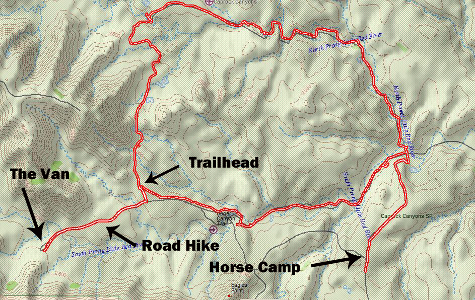
By the time I got from The Van to trailhead and trailhead back to The Van, plus throwing in a side-trip up to the Horse Camp along the way, I ended up adding about 3.5 additional miles of boot-wear to the day.
And that's important because I'm not sure how long I've had this set of boots or how much ground they've covered, but they are definitely showing signs of approaching their last miles.

Because I chose to leave The Van sit where she was, the first and last mile of today's hike was along the road.
It wasn't all that bad this morning since I had the road to myself, but hiking back to camp in the afternoon was a whole different story. But that can wait until later.

As I climb up the road I look back to where I've come from.
I'm camped at the end of the road, somewhere down there at the base of those red cliffs.
I know, I know, but hey! Someone's gota do it!


Eventually I come to the junction of the South and North Lower Prong trails,

but this is also where the Wild Horse Trail intersects the trail system as well, and before I continue on my way I make a side-trip up to the camping area, and beyond to a viewpoint out on the main road overlooking Eagles Point. (Turns out there were too many people messing around at the viewpoint, which isn't surprising considering how close to the road it is, so I turned back without having checked the info-plaques for any updates since last time I was here.)

Just a few steps into this little bonus excursion I encounter this cut where the trail begins to climb.
I sure hope I don't encounter any of those Bison along here! And yes, some of those tracks there in front of me are shod hooves of horses, but others are the hard-edged, soft centered tracks of Bison.

But I make it through without encountering hooved critters of any sort and find appropriate symbolism on the other side in this juxtaposition of the sturdily harsh and delicately beautiful.

Many of the Texas State Parks have horse-camps. What not everyone realizes is that, just like horse-camps in National Forests, you don't have to have a horse to stay here. In fact today only a small percentage of the occupied campsites included horses.
For instance, that truck-with-trailer in the distance at the top-center is part of a horse-less Scout Troop contingent from Amarillo - at least that's what it said on the side of the trailer -

and when I went by, instead of horses, the Scouts were using the site's pole-corral ( I took this photo a few days later after they were gone.) as an arena for a scouting-skills rodeo including knot-tying, shelter building, and plotting compass bearings on maps.

The campsites themselves in horse-camps can be pretty spacious - notice the site's designated pole-corral tucked back there in the top-left - just be aware that a high percentage of the larger rigs that fit into these sites, and virtually all those big, massive, and highly popular, combination horse/RV trailers, have generators and they are not afraid to use them!

After my aborted attempt at the viewpoint and poking around the horse camp I headed back down again towards the trail-junction, hiding there behind that circled cluster.
Behind the junction is a mesa with a trail on top of it, but I'll come back another day for that one.
Today I'll be hiking along the base of that mesa towards the upper left of the photo and on up the North Prong Canyon.

But first, just as I approached the junction, a hiker turned the corner and started up the trail in front of me. To give her time to get well ahead of me I decided it was lunch-time and found a convenient downed-tree to perch on for a while.
Other than the horse-camp this was my first people-encounter of the day and being a Saturday I figured I wasn't doing too bad.

Once I resumed my hike it wasn't long before I started coming across the unmistakable mud nests of Cliff-Swallows tucked under many of the overhangs cut by the river. (Yep, this is the 230 million year old Permian layer. You can tell by the seams of gypsum just above the nests)

Only thing is, I saw no occupants, in the nests or in the air. I found that a little troubling. Seems like they should be here this time of year.

At one point along the trail I did sight the very rare Horcunde Hort.
For those non-Scandinavian speakers that's John Deere. (Yeah, we watch too many Scandinavian TV shows, but lately they are better than the fantasy crap produced here in the US.)
Obviously this beast was parked here for the weekend and will get back at cleaning up the trails during the the less populated week.
Honestly the trail is already more than adequate for hiking, in fact it is actually way too much trail, but because people have an annoying tendency to do things they shouldn't the rangers need to be able to get side-by-sides loaded with rescue-gear and litter-baskets (No! not the kind for trash, but rather the kind for people - although - when you think about it - - -) back into the remote areas.

As you would expect on a weekend, from here my bipedal encounters on the trail started to pick up, especially once I made the turn onto the North Prong Spur which is relatively close to trailhead parking and shared by a couple of different trail systems.
Once I got back to the official trailhead it was clear why.
This trailhead parking lot can handle 30 or so vehicles in proper parking spots, but that wasn't enough and vehicles were overflowing onto the shoulders.
Again, not that I'm complaining - OK, I might be complaining a little - - - but it still beats walking the aisles of Walmart!

I tried my best to distract myself from that ugly scene at the trailhead as I prepared to make that last mile of road-hike back to The Van.

Uh-oh!
It's all well and good for those in vehicles to stop and tease these guys (Yep, a pair of bachelor bulls) and get them all stirred up by hanging lenses, and tablets, (honestly who in their right mind would use a tablet as their primary camera?!) out open windows and calling to them like they are the family dog, but give me a break! I'm on foot out here!

I hung back in the shade of a squat cedar waiting for the two of them to wander on, but the pair showed no inclination to leave the vicinity of the road. Why would they? Some of these idiots that were creeping on by were throwing bread and potato-chips at them. (We are such a stupid species!)
It felt like I was stuck there with the bulls between me and The Van for three hours or so, which means it was more like 30 minutes, and they just weren't moving. They would drift over to the shoulder and graze a little between vehicles but when they heard tires-on-road they made sure they were right up on the road waiting for the next treat.
Unless I was going to sit out here until dark, which didn't seem like a very good idea, I was just going to have to get proactive about the situation! I picked one of the gaps between vehicles (I couldn't see very far down the curving road but I could hear the tires almost as well as the Bison.) and briskly eased my way past, hoping they stayed there along their side of the road as I stuck to my side. (My side of the road was an abrupt drop into a gully so I was limited in how far away from them I could get.)

But I obviously made it, and in time for sunset-at-camp.
Little did I know that was not going to be the last of my Bison encounters for the week - - -
Sometimes I think that bison are smarter than the average tourist. They usually show more self control at least.
ReplyDeleteNice hike. Looking forward to the pack reveal.
Yep, we're the only species where some individuals do absolutely nothing for our-kind yet can't survive without others of our-kind doing, even basic, things for them.
DeleteQuite a hike. Great shot of the bison hoof print. I thought last Sunday was Saturday and couldn't figure out why the two bike shops I went to were closed. Mid afternoon I realized it was Sunday. I guess I need one of those pill boxes to carry with me.
ReplyDeleteI'm just glad he wasn't stepping on my toes at the time!
Delete