
By tonight I will no longer have the campground to myself, but right now (Friday Apr 29) it's still early, just shy of sunrise, so I have time for one more hike before the crowds move in tonight and I clear out tomorrow morning,

so I might as well make it a serious hike.
At just under 7 miles it's not the longest hike of the trip by any means, but since about half of it is up on top of Haynes Ridge, 6 to 7 hundred feet above me, it's no walk in the park. - OK, Technically it is a walk in the park, but you know what I mean.
And to make it more of a challenge, by making the hike counter-clockwise I will be coming down the Mildly Terrifying section and I don't know about you, but I've always found going down steep stuff more difficult that going up, both physically as well as mentally, and I don't think I'm alone in that. (The fire department never rescues a cat that got stuck going up a tree, it's always the coming down that gets them!)

For the umpteenth time this trip I set off on foot up the road in order to reach the trailhead about a mile away, only this time, probably because I know I'm on my way up there, the heights of Haynes ridge loom heavy off my left shoulder under the variable clouds.

Once I reach the official trail head that first half mile is pretty straight-forward, though there are a couple dips and swoops in the trail that make mountain-bikers question their sanity.
The end of this first segment is defined by that notch up there. A notch that is always fiercely windy even on calm days because it s the only opening in the divide between the North and South Prong Canyons.
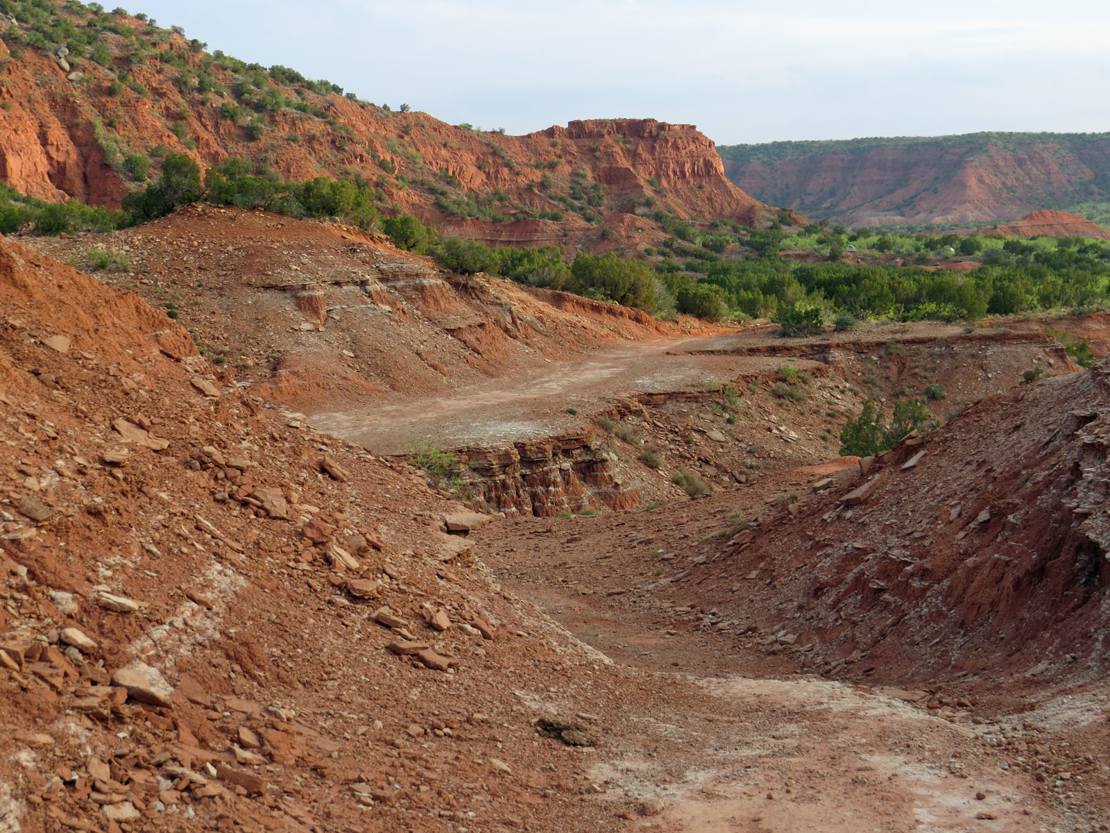
Once you get through that notch, usually twice because you've had to go back and retrieve your hat after the first attempt, the terrain starts to get a little more serious.

Except you don't know serious until you make that sharp left a third of a mile later onto the Haynes Ridge Overlook Trail.
You see that arrow up there?

If I use all the zoom I have, you can see that's pointing at another trail-marker sitting right where the trail tips over the lip between ridge-top and ridge-face. And it's my job this morning to get from here to there. (and beyond, but we'll worry about that when we get there!)
Ahh yes! Breath deep. Don't you just love the smell of - well - Permian dust and flop-sweat in the morning? (What the hell do I think I'm doing?!!)

But before I can cover that last little bit of flat trail the solitude is broken by the growl of a small engine as this group passes me.

But it wasn't entirely unexpected.
Back at the trailhead I encountered an assortment of vehicles and work-trailers

festooned with the TXCC logo.

And I had already spotted their encampment out there at the nearby backpack camping area.

Fortunately for me, the side-by-side dropped off a few trail-workers and went back to get the rest while that first batch stayed put and made final preparations for the day.
Also, they were only working on this first steep part of the trail so wouldn't be following me up onto the ridge itself,

so by locating that trail-marker at the base of the climb and quickly slipping on by I was able to get out ahead of them and never saw or heard them again.
( As I start the climb it occurs to me that I have a 40 year old daughter - oh, sorry kid, 39 for another month or so - so technically every one of these conservation corp kids is young enough to be my grandkid. - - - Again - - - what the hell do I think I'm doing out here?! )

I wonder of this is one of the sections of trail the work-crew will be "fixing" today?

Within a few short steps up the climb the vista of the North Prong Canyon starts to unfold.

And continues to unfold even more

every time I stop on the way up for a breathless look around.
Alright alright - yes - breathless as in the more literal sense of the word rather than the scenically driven figurative sense , but give me a break! It's the equivalent of climbing the steps to the top of a 60 story building - and like The Big Bang Theory, the elevator here is permanently out of order!

but finally there's only a few more steps to go before topping out up on the ridge!

If you check out the topo you will see that the ridge-top is never very expansive so from the trail, precariously tiptoeing along its blunted-knife edge, there are views of the various canyons below

on both sides.

OK, a few days ago it was a seemingly random photo of my boots on the trail that I can't, for the life of me, figure out why I took. So if anyone, anyone at all, can come up with a halfway credible reason why I took a photo of my fingers today I'd really appreciate it, because this apparently pointless randomness is starting to get worrisome!

I believe that this trail up here on the ridge is the only one in the park that is a true trail and not actually a small road.

But then again, these days it would take a helicopter to get a vehicle up here.

I qualified that helicopter statement with "these days" because as you get toward the western end of the ridge there are some areas that, with a little imagination, you can envision being used to graze animals,

and sure enough, there are indications that that's exactly what was going on at some time in the past.

But to be fair, 'sometime in the past' Haynes Ridge (circled in red) wasn't only traversed by this lonely and difficult to reach trail (in yellow) but was connected to the flat and highly accessible high plains on the western end (very top left corner of the image) with a track (green) that was good enough for pack animals to traverse as well as driving livestock along.
Changing land-use, the park boundary, and adjacent private land have long since cut that track off, (though the gate is still there) but it is a reminder that the ridge wasn't always as empty as it is today.

But now, when I get to the trail intersection on the west end of the ridge, marked by this ground-hugging, delicate little fruited cactus about the size of my lens-cap,

I only have a few choices. All of them involving dropping 6 to 7 hundred feet down a steep trail, But only one if those is a route I've never taken in the downward direction before.


But hey! I said I was slightly defective, not stupid!
So when I get to the edge, the spikes go on,

because that first step is a doozy!
I wish I could say that I stood up there on the precipice and let out an almighty, and manly, roar before stepping off the edge

and easing myself down, and around, and down, and down some more, to a rather mild, if precarious, traverse,

only to be dumped out into another one of those down situation,

followed by an off-camber traverse on loose rock, followed by more down, and so on and so on.
Yeah, I wish I could claim that defiant roar - but truth is there was no roar. In fact there just might have been the slightest bit of whimpering involved.
But you can't prove that so I'm not admitting to it!

After a bazillion years of clinging to that "trail" with fingernails and spikes I made it to here.
On the other side of that bowl-shaped hole just left of center is my escape path.
If it wasn't for that airy drop where the other half of the bowl used to be, going this direction isn't as bad as going the other way. Especially since I know that where the trail disappears behind that bush on the far right is where the final decent starts.

And from the top of that decent I can see camp way out there at the far end of the canyon, or at least where my camp is. (You know, old eyes and all.)
That ledge sneaking around behind that Smart-Car sized rock is the one that lures the uninitiated hiker. It's not until you shuffle around that point out there on the now barely boot-wide ledge that you realize that the ledge pinches out on the other side into nothing but air and gravity.
But I know better - now -

and all I've got to do is negotiate this one last drop before I can stand on the canyon floor with manly, if distressingly grey-haired, chest all puffed out at my accomplishment.

From down here, on the wide, stable ground of the canyon floor, it's tempting to turn around and thumb my nose at that ridge that I've now conquered both ways, but the reality is that ridge couldn't care less if I'd been there or not.
Besides, it's likely I'll be back one day, so it wouldn't do to piss it off!

Can you see that tiny little vertical white streak up there?

That's the mark of a nesting American Kestrel, a member of the falcon family that nests in convenient cavities, preferably ones with a view over their domains.
From here it's an easy stroll back to camp and it's time for me to leave the canyons to their rightful occupants because in the morning I'll be heading to San Angelo, which I already wrote about here.
Beautiful country
ReplyDeleteYep, it sure is
DeleteThis comment has been removed by a blog administrator.
ReplyDeleteYou raise the interesting question of the signification of pointFUL randomness.
ReplyDeleteI've decided to just ignore these worrisome random events and get on with more important things.
Delete