It's Friday, January 29, and as is typical in this Corona-age of crowded parks and short trips, I must vacate my campsite to make way for the weekenders that make their reservations farther ahead than I do.
But, as is also typical, I'm going to sneak in one last hike before hitting the road early enough to get myself to the other side of the city before the afternoon rush kicks in. And I'm not talking the good kind of rush, but rather the road-rush of frenzied hoards of commuters trying to get back home for the weekend before doing it all over again on Monday.
Down at the southern end of Pedernales Falls State Park, much of it south of the county road that cuts through down there, is the Madrone Trail.
This is as far from the campground as you can get so, since I was moving The Van anyway, today is the perfect time to actually drive to the Madrone trailhead so I can get right on the trail without a lot of preamble perambulating.
The Madrone Trail is a point-to-point so to make a loop out of it requires adding in some bits and pieces of other trails as well, including that bit of the Juniper Ridge Trail which forms the 'toes' of my foot-like track.
The Madrone Trail actually crosses the entire east-west width of the park along its southern border, but I didn't feel much like rushing my hike in order to beat the rush - since that seemed overly redundant in terms of rushes - so I only hiked a portion of it as I made my counter-clockwise, five-mile loop this morning.
After using fossil-fuel to get myself to the trailhead I switched to foot-power and slipped through a gap in the fence
to start my hike along the empty, peaceful trail.
Unfortunately too empty in one respect.
The Texas Madrone is becoming scarce in some of its former habitat and here at Pedernales is no exception. In fact, despite being on the lookout, I didn't see any full grown specimens on this hike. (Of course, to be fair, I only hiked about half of the actual Madrone Trail today) When trolling through past photos for an example I discovered that over the past 10 years I have photographed this particular tree twice before.
With it's deep orange-red coloring, distinctive shedding bark (The tree is sometimes called Lady's Leg because of the smoothness of some of the branches/trunks.) and rosettes of fall-tinted red-green leaves this is not an easy tree to miss,
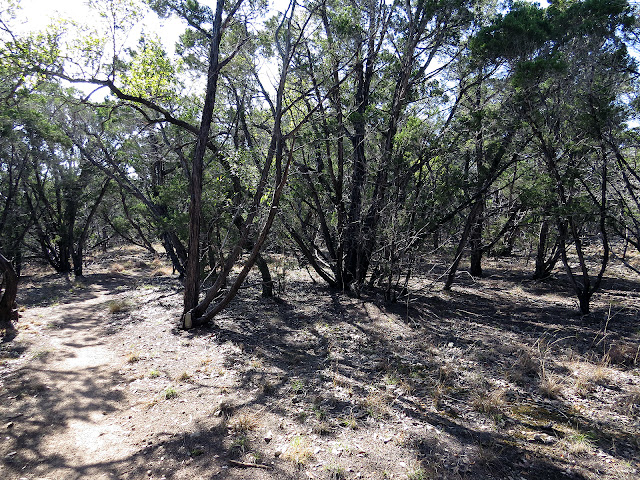
but the best I could come up with this hike was these two shrubby examples (one right and one left in the photo) tucked under the Cedars
and a seedling that someone is trying to protect with a stone barrier.
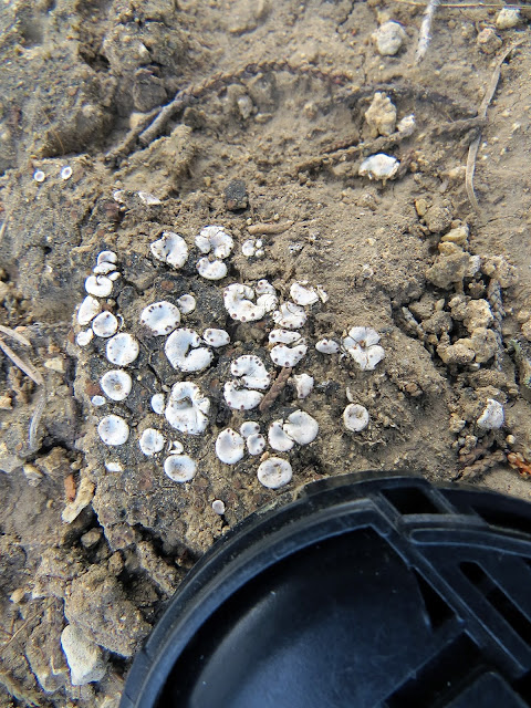
But my slow, plodding pace was not without other rewards, such as this landscape of speckled silver-dollars (probably not their official name but close enough for me) all clustered in a mound
smaller than my lens-cap.
laid out like a Siren Song blanket on this nearly prostrate tree, just daring me to climb on up and take a nap. (I didn't. - I thought about it - but I didn't.)
When the trail took me around the southern member of the Twin Buttes I decided that its summit would make a good lunch-spot.
And I was right.
But since I had to bushwhack a bit to get to my nice comfortable spot-with-a-view, I took some precautions.
If you look close, there at the end of the arrow, you can see that I've propped one of my hiking sticks up against a branch. Even being black, (I've talked before about how I don't like advertising my presence so avoid the neon colors of many other brands.) any straight line like this tends to stick out out here in - well - the sticks.
In this case the hiking stick is marking the direction I need to go when I leave my lunch-tree.
And by the time I get to that first stick and retrieve it,
I'll be within sight of my bright yellow towel hanging off another branch there in the distance.
OK, maybe not so bright anymore now that I've been using it while painting a few sketches on the go, but I'm reluctant to use the super-bright hunter-orange bandanna I also carry unless I really need to.
In addition to the usual "hey you dumb-ass hunter, don't shoot me" I also carry the bandanna for the O part of my STOP process in case I misplace myself out here, but it just screams so loud I don't like using it unless I have to.
Anyway, bright or not the faded and stained yellow towel is still easy to see from a distance and placed near it is my second hiking stick, pointing the way back to the trail.
Over-kill on the precautions?
Oh definitely.
Especially when you consider (A) I only came this way less than an hour ago, (B) I'm also tracking myself with a GPS, (C) and the trail wraps around three sides of the butte with a fence-line and road not all that far away on the fourth side, so all I had to do was go downhill to 'find' myself.
But I do it anyway, not only because a little extra caution rarely hurts, but also for the practice. Same reason I run the fire-pump once a month, not only to make sure it is operating, but also to keep the steps necessary to hook it up and get it operating fresh in my mind so that I have a better chance of performing those steps properly when in a panic.
And apparently it works because after thousands of solo hikes here I am, standing at my desk in the barn, writing up my last trip and thinking about the next.
___________________
STOP
Sit: This is probably the most difficult step in this process because not only do you first have to admit that you don't know where you are, it also goes against the double-whammy of your body's natural fight-or-flight response. But it's the most important thing you can do right now. Just as soon as you feel like you've misplaced yourself - sooner if possible - sit down. This has the immediate effect of preventing you from making things worse by allowing that initial concern (OK, downright panic) to take over and drive you into doing something, often many things, one on top of the other, that may turn out to be less than helpful in resolving the situation. (Fight: This is the wrong spot so I'm going to fight my way to somewhere else right now, even if I don't have any idea where that somewhere else is, or Flight: I don't know where I am so must get away from here as fast as possible and I don't care if I know where I'm going as long as it's somewhere else.) And the body's natural physiological response to sitting also helps lower your heart-rate and adrenaline levels. To help with that even more sip some water, chew on some trail mix, sing a dirty limerick, do anything "normal" that will allow your mind to clear and settle down.
Think: Now that your mind is functioning rationally think about the situation. Where you were last time you - well - knew where you were. Where you were going. And how you got here. Often this is all that's needed to get you back on track, both figuratively as well as literally.
Observe: At this point, if you still can't put your feet back on the trail with confidence look around. Can you see landmarks that you can take bearings off with your compass and triangulate your position on your map? Maybe you can even spot your back-trail? (Just make sure it's yours and not a random game-trail.) Can you hear traffic or a river? Chatty hikers? To expand your picture further mark where you are right now with something highly visible (Yep, there's that screaming bandanna.) then explore in a radius around that point, always keeping your marker in sight because, until you are "found", where you are right now is the closest you will ever get to where you are supposed to be.
Plan: OK, Now that you have the picture, what are you going to do about it? Here, depending on your skills, the weather, and the resources you have with you, there are several possibilities. You can take a bearing and walk towards the traffic noise, towards the river, towards that ridge-line. (Statistically, there's a higher chance of finding people or infrastructure by going down-hill, down-river, than up.) If you left a trail-plan with someone you can hunker down right where you are, build a shelter with the resources you have, and wait for someone to come looking. (If the sun is getting low you want to do this - build a shelter - right now regardless of your ultimate plan because building one in the dark sucks!) Even if you plan on walking out, you still might want to hunker down for now and observe your surroundings in the dark, when the far-off glow of town lights can be seen, or moving headlights mark the location of a distant road impossible to see in the daylight.
______________________


In my youth -- up until age 30ish -- I'd wander the wilds for hours, albeit not days, and find my way back using landmarks.
ReplyDeleteThen, in my late 50s when I finally escaped, I got lost a couple of times a mere hundred yards from camp. (Those junipers and pinyons can look a lot alike.) Yessir, hit whar pure luck ah found muh way bak.
I bought a GPS and learned how to use it. My sense of direction and ability to recognize landmarks just up and went. I carry an extra set of batteries...even when just ambling out tuh take care of morning bidness.
Bein' lost jus' ain't no fun et awl.
Yep, Ain't technology great! My grandparents embraced radio, my parents embraced TV, and now I embrace smartphones and GPS.
ReplyDelete