Remember how I claimed a few posts ago that I live a charmed life?
Well after a gloriously sunny day yesterday storms moved back in overnight and there was hail bouncing off the roof of The Van around 0200.
But here's where the charm kicks in - by this morning (March 23) this round of storms had blown on through and it may be a little cloudy, but the weather is great.
And unlike the tenter's that were scrambling for their cars in the middle of the night, I was getting a good night's sleep all safe and secure in The Van, so I'm off early to tackle the West Trail!
The trail starts off easy enough,
quickly passing what's left of the old pipe that used to direct spring-water down to what is now the park superintendent's house tucked into a small bench across the canyon from the trail,
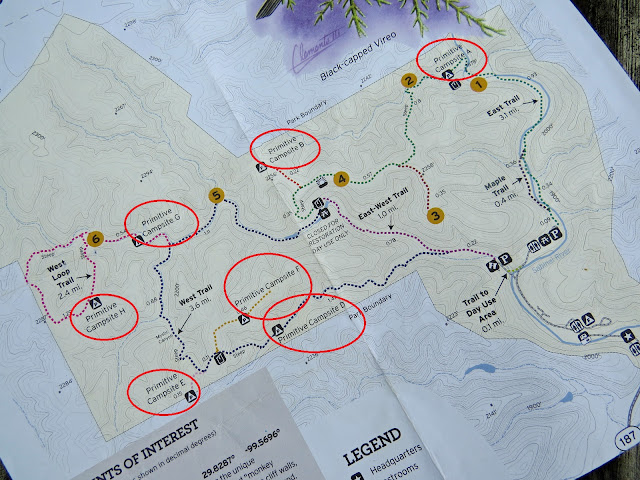
and after a very mild, one mile or so climb, the trail slips on by Primitive Camp D.
But with only one - oh let's be generous and call it passable - campsite, even though it is practically right on the main trail
At 2900 acres, with only 2200 of them actually covered by a developed trail system, Lost Maples is far from the largest park in the state's system. In fact it's a challenge to string together a 10 mile hike in this park without looping back on yourself. But it does have the largest number of primitive camping areas, with the possible exception of the uber-massive Big Bend State Park,
and after hitting two of them over on the East trail the past couple days, today I'll hit three more, plus a bonus stop. (Don't worry - just in case you were for some reason - I'll pick up the remaining two primitive camp areas tomorrow.)
Each of the parks has it's own rules about the primitive sites. For instance at Colorado Bend you are assigned a particular camp site, marked with an official post with number on it, in a particular primitive camp area. Here at Lost Maples you pay your fee ($10) and then just go out and pick a likely spot in any one of the designated areas.
If, by chance, you picked Primitive Camp D because of it's proximity to the trailhead and the limited climbing needed, but were not impressed when you got there and decided to try your luck at camp E or F instead - well let the climbing commence!
Because it's a steep slog with full pack from here
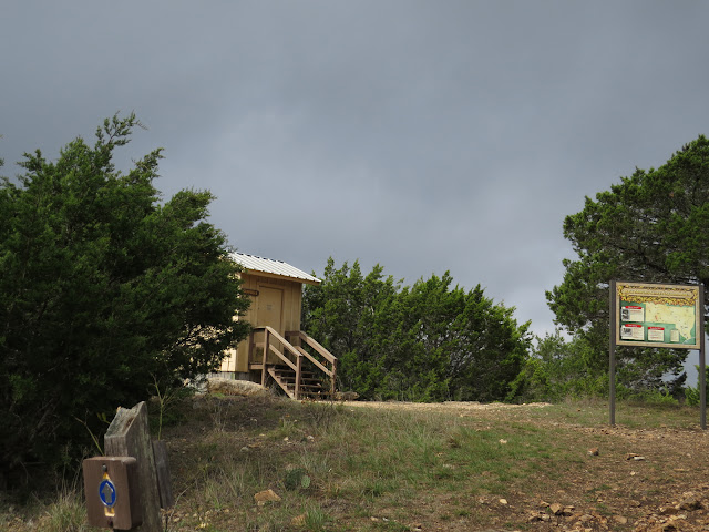
up to Nirvana.
OK, I agree, Nirvana isn't usually associated with a composting toilet, (Unless perhaps you are in severe personal distress) but in this case it marks the end of the climb.
If I was passing straight on through this would be a short reprieve as the drop down to Mystic Canyon starts just on the other side of those trees,
but passing on through isn't part of today's plan.
A while back, some years ago when I wasn't in the shape I am today and didn't have as much in the way of stamina, I wearily came up this service road from the other direction (It's pretty dang steep!) and spotted an antenna of some sort sticking up along the horizon out here in the middle of nowhere.
Of course I was curious and expected that there would be a well-defined track off the service road that would lead me to that antenna so I could explore this phenomenon further. But when I didn't stumble across anything obvious I, given my lack of energy, let it go in favor of getting back down off the ridge and into my camp-chair.
Today, as long as I'm up here, maybe I'll give it another try.
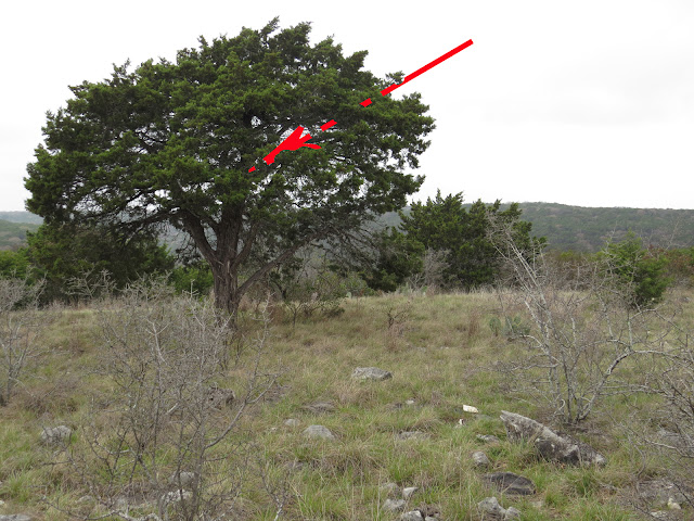
I think that antenna was somewhere over there.
Or maybe back there?
Wherever it is I still can't find an obvious track back to it so it's time for a little bushwhacking.
Ah-ha!
Found it!
And I've seen these before.
It's a transportable solar-powered, telemetry connected, self contained weather data collection station
operated by Texas A&M in conjunction with the Texas Parks and Wildlife Department.
This is a Fixed RAWS station by Forest Technology Systems and in this particular configuration, called Fire Weather, in addition to the usual sensors such as wind, rain, temp, humidity,
this one also has a solar radiation sensor that records total total light, (global sun + sky radiation)
and a fuel-stick sensor that indicates the moisture content and flammability of the burnable crap in the vicinity. (That grey stick is a carefully selected and precision-prepared birch dowel with a temperature and humidity sensor embedded in the middle of it.)
These stations, in addition to general weather conditions, are used to help plan prescribed burns as well as manage wild-fires.
And yes, they are portable and designed to be assembled in a few hours by a two or three person crew with a few hand-tools and no need for concrete or site-engineering, but even disassembled it's a pickup-bed load of gear, yet I had seen no sign of an access or maintenance track into this station.
But after bushwhacking my way back there to it, guided only by glimpses of the skinny mast sticking up above the vegetation, I came back out a different route and when I turned around what looked like random rocks now became cairns marking the way in.
But unless you knew what you were looking for, it would be easy to miss while walking by on the service road.
Just as I regained the main trail and was feeling pretty smug about another successful bushwhack Mother Nature slapped me down into my rightful place with this graphic display of the power of the February storms.
These are some fairly significant living trunks snapped into splinters by the combined power of ice and wind.
So as I wandered into Primitive Camp F I couldn't help but be glad I wasn't up here on this exposed ridge in a flimsy tent while that series of storms savaged the place.
As is usually the case, there were no campers in the area today,
but I did encounter goat-poop. (Aoudads) No goats, but goat poop isn't too bad either! (Yeah, I know - I heard it before - that guy's weird.)
Then I wandered back on past Nirvana, otherwise known as the composting toilet, and over to Primitive Camp E where I set myself up with a chair and table for lunch.
Primitive Camp E is near the park boundary and it's clear that the private owner on the other side of the fence takes this boundary seriously. (I'm holding the camera through the 6' fence to take this photo.) There's a lot of fence-line out here and it's only been a month since the February storm tore things up, yet a crew has already been through on the private side of the fence with some heavy equipment clearing up the damage.
Re-fueled by lunch, and with my fires freshly stoked by a nice break, I dropped down off the ridge into Mystic Canyon where the trail and the creek-bed
are often one and the same.
And here I was treated like royalty, or a blushing bride, my path strewn with fresh flower petals.
Yeah - OK - So I know this sweet carpet wasn't just for me, but sheesh! Can't cha just leave a guy some of his delusions?!
From the base of Mystic Canyon it's a fairly easy dawdle to pick my way between the ridges down Can Creek
back to camp where I was briefly enthused to find that the camp of a half-dozen pre-teen kids and at least three sets of parents had picked up and left while I was gone. Not that they were a bad group, the kids pitching in and helping each other put up the tents or find their coats when the temps dropped, or carry their food from fire to table, but - well - you know - they were kids! - Need I say anymore?
I said briefly enthused; because shortly after I took this photo a group of about a dozen hairy bicycle riders rolled up and started pitching tents and hanging socks everywhere!
Fortunately they had already been on the road for 24 days and quickly crashed out, each in their own little one-man tent.
But in that euphoric gap between kids and bike-riders this guy dropped in to boldly check out my fire-ring in the hopes that I had left a few scraps laying around it. (Like a Grinch, I hadn't) I can't say for certain that this was the Raven that followed me around yesterday, but then again I can't say for certain that it's not either.
And on that note I wrap up another great day of hiking.


Nice hike.
ReplyDeleteI used to sleep well in my backpacking tent during storms. The worst part was packing up the next morning with a heavier wet tent. Now I’m grateful for hard sided shelter.
Flower petals on the trail makes it a special day.
I remember packing up our family tent when I was a kid. Of course being used mostly in Michigan it was often wet. It was big enough for 5 of us and was also canvas. Yep, real canvas and folded up still took up half the trunk of our rather large 1960's car. And that sucker was heavy! In fact once, following a storm, it was the only tent in the campground that wasn't up in the trees.
Delete