Monday, March 22, 2021

Today the East Half of Juniper Ridge

 It's my last full day here (Jan 28) at Pedernales Falls State Park this trip and I knew it was going to be a long one (I was right. It was over 13 miles of hiking) so I headed out early this morning to hike the eastern  end of the Juniper Ridge Trail.


In deference to today's total anticipated hiking distance, I took the more direct route from campground to Wolf Mountain trailhead by hiking the road. Well not really the road. There's a (modern) water-line buried parallel to and just a few yards west of the road and the park service keeps the ROW over top of it mowed, which makes for easy hiking. Better than the edge of a paved road anyway.

Again, the Juniper Ridge Trail doesn't have any trailheads of it's own, so just like when I hiked the western half a few days ago, I had to start off on the South Loop Equestrian Trail


and travel it for a while before intersecting the Juniper Ridge Trail at about its mid-point, right about where the asterisk is pointing on the previous map.


I just showed you photos of Juniper Ridge Trail a few posts ago, and since the trail is very similar its entire length I won't bore you with more of the same. Though I was anything but bored slowly hiking the ledges along the ridges which I had all to myself.


At the far eastern end of the Juniper Ridge Trail I came to the stone house.

This was built by the Trammells around 1870 when they moved onto this tract of land.

By today's standards the whole house is about the size of a modest walk-in closet, but after the Trammells were finished with it the Jones' moved in and continued to farm the nearby fields as well as raise goats.


As you can imagine, the long occupancy of this house left behind


a rich array of artifacts.

Of course you are not supposed to cart these artifacts off and keep them for yourself, and it's nice, surprising even for a curmudgeony old pessimist like me that is quick to believe the worst of people, to see that many people are willing to leave the artifacts they find behind for others to enjoy and peruse, including scholars that know how to get the most knowledge and information out of them.


Trammell field #1 lies just west of the stone house and was walled in.

The wall is partially tumbled down now and overgrown, (When I look at the jumble of rocks I think of all the work that went into hauling and placing each one of them, by hand, which tells you how important these walls were to the builders.)  but I didn't have any trouble finding a secluded spot to settle in for a lunch shared with the spirits of those original European inhabitants.


After a quick lunch, because it was already getting late and I had a long ways to go yet, I made the obligatory stop at Jones Spring, which probably played a big part in the location of the stone house, but only a quick one before continuing on, since I've gotten distracted here in the past and have been known to spend hours just watching the wildlife in the small pool.


From here the way back towards camp is along the Wolf Mountain Trail.

Its pretty much track-like surface is easy hiking on weary old legs, but - well - kinda boring too. So right about where that wolf-track is on the map above I bailed off the Wolf Mountain Trail and back onto the horse trail.

The two trails don't actually intersect but they aren't all that far apart horizontally, if you know where to look. The horse trail is a ways above the Wolf Mountain Trail and you can't see one from the other, but after many hikes through here, some map-reading, and a little bushwhacking, I've made this particular cutoff more than once.

It would have made for a shorter hike to stick to the Wolf Mountain Trail, but I find the horse trail more to my liking. I'm kinda stubborn that way I guess.


It also would have been a little shorter getting back to camp from the trailhead by retracing my steps along the road, but once today was enough. Instead I stayed on the horse trail and trekked across the burn area once again.

I'm not sure if this burn was prescribed or wild, but based on the number of large, decent hardwood  trees that were killed, the ragged margins of the burn,


 and the fact that it was hot enough to split rock, I'm leaning towards wildfire.


Another reason I chose the longer way back to camp was that, anticipating coming this way again, I had left my marker telling me where to leave the trail for the final bushwack back to camp in place when I did the first half of Juniper Ridge a few days ago, so I needed to come back and dismantle the marker before I finished up this trip.

Which is actually tomorrow, the finishing up this trip bit.

Next time my final hike here at Pedernales before heading home.


Monday, March 15, 2021

The Same but Different and other Nonsensical Stuff

 I've pointed out before that many Texas State Parks have closure dates because they hold hunts of various types, the most common being deer.

Pedernales is no exception.


I've also included this photo in a previous post of a typical blind maintained and managed by the park system, this particular one being in South Llano River State Park.


Pedernales Falls State Park holds hunts as well, but they use a different kind of blind


that, in my opinion anyway, is more eco-friendly and blends in with the surroundings much better.

True, this U-shaped, stacked Cedar cuttings, style of blind does require periodic refreshing with more Cedar boughs laid on top as the old boughs gradually decompose from underneath, but then again, there are certainly plenty of Cedar boughs to be had around here just from trail maintenance alone. Besides, the plywood blinds require periodic refreshing too.

So my vote goes to these natural Cedar bough blinds.


Speaking of hunting.

Not far from the cemetery mentioned in the last post, right where the State Park trail makes a sharp left to follow along the boundary fence, there's a wire gate, the kind with no hinges or latch, the kind you have to untwist the wire and drag aside, that leads to a track on the adjacent private land.

It's there to be used as an emergency evacuation route in case people are trapped in this part of the State Park by a flood on the river.


On the private side of that fence, taking advantage of a large, for this area, open area, is a more elaborate version of a deer blind.

Many ranches here in Texas, with it's ridiculously small inventory of public lands, supplement their income by hosting hunters. This usually takes the form of hunting leases, where a hunter, or group of hunters, pays an annual fee for a hunting lease. The rancher gets the additional income (Good leases are not cheap!) and the hunter gets controlled access during certain in-season dates.


Posted near that gate, again on the private side of the fence, was this new sign.

Though it makes sense, what with the rash of people - agritourism participants - not wanting to take responsibility for themselves lately, this is the first time I'd seen the term Agritourism as part of an official document. (By the way, agritourism is apparently not in my spellchecker yet.)


And as long as I'm throwing nonsensical stuff into this post - - -

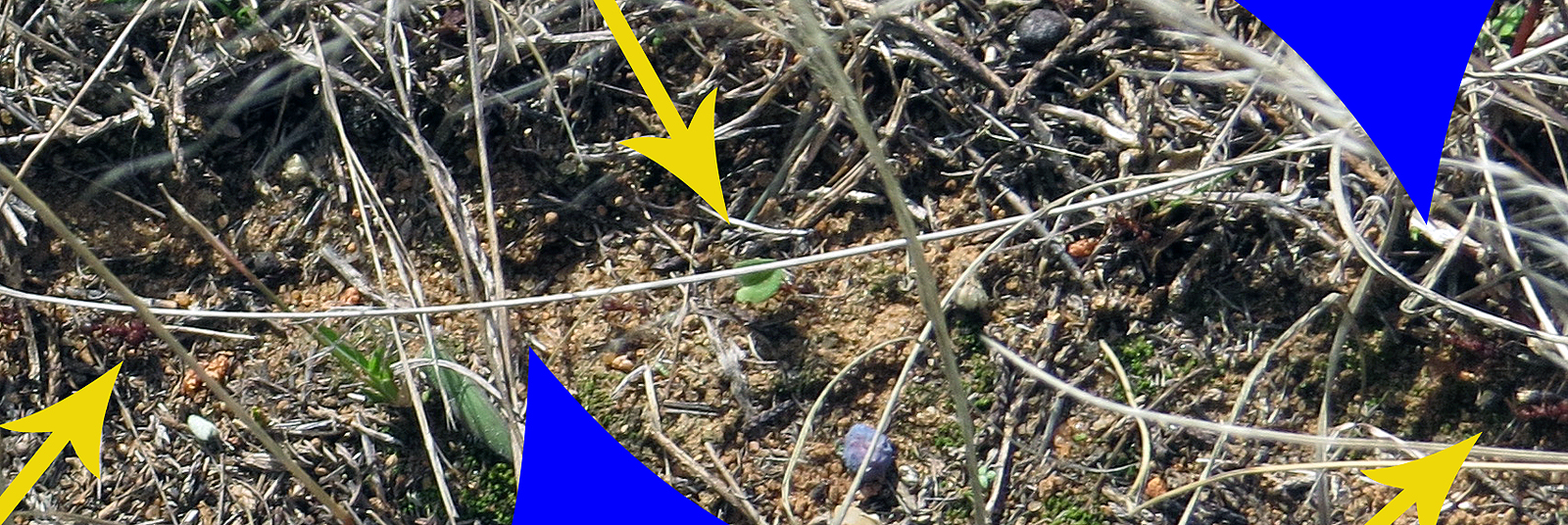
On the same hike as finding the agritourism sign I ran across several game-trails, though most probably wouldn't notice them let alone call them game-trails.

The 1 to 2 inch wide trails, pointed out by the blue arrows, cut not only through the ground-litter but can even be traced across the 1/2 inch gravel covering parts of the trail I'm hiking on.

The yellow arrows are pointing at the architects of the little trails.


 These are Leaf-cutter ants. A monster of the Texas ants.

If you watch, the ones going one way, left to right in this photo and marked by the left and right hand yellow arrows, are just moving along, while the ones going the other direction, marked by the center yellow arrow, towards the ground nest, are carrying stuff. Usually it's leaves, or parts of leaves, some so large the ant stumbles along blindly, but relentlessly,


but a few of these returning workers are carrying Juniper berries. Though these few often seem to give up before getting to the nest, abandoning piles of berries right in the middle of the pathway.


Whatever they are carrying, or not carrying, you don't want to mess with these guys!

Both ants in the image above are facing to the right. The one towards the bottom of the photo is a soldier ant, out there guarding the trail and workers. Look at the jaw-muscles that make up most of the head on that sucker!

Even the regular worker ants, like the one above the soldier, have impressive jaws in their own right.

So best just get out of the way and let them do their thing. They've been at it since long before us humans existed and will still be at it long after we have excessed ourselves into extinction.

OK, Enough of this random crap. Next time I'll complete the eastern half of the Juniper Ridge Trail and stop off at the remains of a 19th century homestead.


Monday, March 8, 2021

Across the River into History


Having covered 20+ miles on foot over the previous two days I figured today (Jan 27) it would be a good idea to keep the hike short - ish. (It turned out to be about 7.5 miles by the time I quit screwing around out there)


A good spot for a short hike here at Pedernales Falls State Park is the chunk on the eastern side that is cut off from the rest of the park by the river.


 So that's why I was down at the river crossing much too early for smarter people.

This is Trammell's Crossing, which is ironic since a trammel is something that impedes progress or freedom. But this passageway into and out of the rest of the world was not named for a trammel but rather for the Trammell family that moved here in the late 1800's and had holdings on both sides of the river.

Depending on recent rainfall the normal water-depth here, actually over there just short of the far bank where the water is deepest, varies from a few inches to a couple of feet. Today it's over half, but not quite 2/3rd's, calf deep.

Around here a reliable source of water results in Cypress trees.

And there are some pretty spectacular specimens to be found along this river.


 But there are also some stark reminders of the periodic floods that sweep down the river.

The water never stays high long, I once crossed the river 5 days apart with a 15 - 20 foot flash-flood tearing through in-between crossings, but when it does get high, trapped as it is between limestone bluffs, it's fast and violent. When I have made the crossing a few days after one of these floods its extent is bookmarked by fresh debris caught up in the trees high over my head.


But the river has been behaving for the past few months so this particular crossing was uneventful.

I used to make a big deal out of water-crossings.

I carried water-shoes with me all the time just in case I ran into one and did the whole remove-the-boots-and-socks, tuck-them-safely-inside-the-pack, drag-on-the-water-shoes, cross, wrestle-the-wet-water-shoes-back-off, dry-my-feet-carefully, and then go through the whole getting-the-socks-and-boots-back-on-and-laced-tight rigmarole. (Whew! I'm worn out just writing about it.)

Now days, as long as I can reach the bottom with a hiking stick, I just plow straight on in.

The only concession I make is that if it's cold (Yes this is Texas, but hey, it is January) I roll my pants up then stop on the other side long enough to pat some of the water out of my socks with a towel. The  rest will dry soon enough as I hike on.


Much of the trail here on the other side of the river


follows an old wagon road called Mill Holler that connected this area with the community of Cypress Mill two miles to the north.  (Lumber mill, cotton gin, general store, post office and school.) At that time this was the connection to the rest of the world as there was no road connection to the south at all.

You used to be able to see traces of Mill Holler road where it left the park through the north fence at an old gate. If those traces are still there today I managed to miss them even though I was looking. The fence looks like it might have been worked on recently and I couldn't find that old gate either so maybe it's gone now, along with the echoes of wagon wheels that traced the road in its day.

Of course I would have to be right on top of it to spot that old gate because it's difficult to see very far now, but before the thin and fragile layer of rich soil over a limestone base was subjected to over-grazing, 'alternative' management practices, and extended droughts through the mid 1900's, all of which changed things, perhaps irreversibly, this area looked completely different than the scrubby cedar thickets of today that shade the trail now and suck up what little water might be available. (Cedars are thirsty little things!)

Back when the early white settlers arrived this was prairie grass-lands prime for grazing, cotton, and even corn, and this little pocket that eventually became the State Park attracted what were called 'old-stock Americans' from the southeastern states, as distinguished from the German immigrants that founded and settled around Cypress Mill a few miles to the north. (Much of Central Texas was settled by Czech and German immigrants lured here in groups by land speculators)


But things change and now a major part of the local population is made up of white-tail deer that seem surprised to see me.

But there are remnants of those other inhabitants if you know where to look for them.

For most of the time I've been coming to this park it wasn't available, but in 2010 a nice 73 page history of this area that mostly focuses on the past couple hundred years was published and is available in PDF format. When it came out it helped fill in some blanks and, for me anyway, has made my subsequent visits richer and more engaging.


For instance, I know now that when I hit the eastern fence-line and look north that area on the other side of the fence used to be called Schoolhouse Flats where the inhabitants of 6 to 9 ranches/farms in the area regularly came together for community baseball games on Sundays.

It's called Schoolhouse Flats because just to west, on this side of the fence-line and lost now to time and the scrub, there was a wood-framed 12 x 20 school/church where local kids went because their parents didn't particularly want them doing their lessons in the German of the Cypress Mill school.


But a couple three decades ago, long before that history was published, right near were the trail hits the eastern fence-line and turns north I stumbled on my own little bit of history - probably because I tend to lollygag and poke around rather than just hike a trail to get it done - During one of those rambling ambles back before the fence-line maintenance track was officially turned into a trail, I stumbled across a cemetery that none of the park people I talked to at the time seemed to know anything about.

It wasn't easy to find back then and is much harder to spot now, even though it's actually just a few yards off the trail. Yeah, back in there behind that scrub.

Like always, as soon as I turned the corner I started looking.


And it wasn't long before I spotted it.

See it there?

That cockeyed post.


This post, like the fence enclosures around some of the graves, probably dates from the late 1930's when the Wheatleys rediscovered the cemetery some 40 years after the last of the about 19 burials.

They knew nothing of the previous inhabitants but cleaned up the cemetery anyway, and did a little fencing around some of the plots as well to keep cattle out, because this was still grazeable land back then.

The post looks like it might have once held a sign of some sort but that was gone by the time I first found the place and, though this place is not exactly a secret, there has been no effort since to make it any easier to spot.


As far as I can tell, after referring back to some of my original photos of the area, not much has changed here since I first stumbled on it several decades ago.


Which I think is kinda nice.


I myself have been able to locate about a dozen of the purported 19 graves, I think anyway. Some I've located are definite, others maybe not for sure.


One I have definitely not located is that of 5 year old Annie Rainey shown here in a photo taken in 1944 and included in that history I mentioned.


But that's OK. It's kinda fitting that I don't know where all the graves are, or who is in them.

Because while other hikers go by only yards away never realizing I, or the cemetery, is even there, I'm here, quietly spending my lunch among the lingering whispers of the rugged, independent pioneers of over 100 years ago.


Headstones aren't the only stones left behind by those settlers.

I paced off this stone wall to be about 200 feet long and not far from where the schoolhouse and cemetery are. It probably dates from the late 1800's and delineated a yard, pasture, or crop-field.


I spent some time poking around behind that rock wall looking for evidence of structures of some sort. A couple of times I thought I might have spotted the rotted remains of Cedar corner posts, but in each case the "posts", while appropriately spaced, turned out to be rooted in the ground, not pounded or buried.

I did find one cluster of stones that may, if you use your imagination - a lot - have once been part of a foundation, but that was the best I could come up with.

History can be very elusive, which on the one hand is kind of fitting, but on the other is very frustrating!


But for now the shadows are starting to lengthen so it's probably time to close the loop and head back to the other side of the river, because there's another hike waiting tomorrow.


But I have one final thing to yammer about.

The image above is an aerial photo and it clearly shows that as I approach the bluff (On the trail marked in blue) before dropping down to the river crossing on my way back, I have passed right by the southern end of what has become known as Trammell field #2 (#1 is to the southeast on the other side of the river near tomorrow's hike.) The field was probably last planted sometime in the 1920's but is still clearly visible in this 1951 photo.

Today the field, which apparently was never walled like Trammell field #1, is grown up with Cedar scrub and is nearly indistinguishable from the surrounding land.

I said nearly indistinguishable. On a previous hike, since I knew it was there and where to look, I was able to poke around and find hints of the field, although the encroaching Cedar is quickly hiding it now. 

But hey! Back to the business at hand.

Though this was supposed to be a short day in terms of miles it's turned out to be longer than planned, so I need to get myself back to camp and rest up for tomorrow.


Monday, March 1, 2021

Ridge Running in Pedernales


The 10 mile Pedernales Falls State Park Juniper Ridge Trail, highlighted in blue up there, is fairly new, having been officially completed within the past 5 years.

It was designed as a collaborative effort between the Park Service and the Austin mountain biking community and largely built by the mountain bikers as a mildly technical single-track.


Because of that this trail feels distinctly different from the rest around here as it zig-zags wildly through the Junipers and rugged terrain of the southern end of the park, often skirting along the ragged, stacked limestone edges of ridge-lines with an abundance of man-made jumps


 and obstacles along the way.


This is in stark contrast to the older, and very popular, Wolf Mountain Trail which follows the track of one of the old roads in the area.

Though I have seen the knobby-tire tracks of bikes on Juniper Ridge, I have never actually encountered any wheeled contraptions on this trail which, as shaded and lesser-traveled as it is, also makes a great hiking trail. 

The shaded portion of my track is the western half of the Juniper Ridge Trail, the rest is just me getting to and from the trail

The shaded portion of my track is the western half

of the Juniper Ridge Trail, the rest is just

me getting to and from the trail


But at 10 miles long it is already an ambitious day-hike. Then, to make it even more ambitious, throw in the fact that this trail doesn't actually touch a trailhead anywhere along it's length which means you have to hike other trails just to get to and from it, and you have an epic on your hands, especially when, like me, you're too stubborn to move The Van from it's campsite to a closer trailhead which adds even more miles to the epic.

Since, as my age keeps climbing up the scale past 'best by' and on towards its expiration date, I've gotten smart enough, usually anyway, to avoid "epic" in favor of being able to move without screaming in pain the next day, I chose to hike only a portion of the trail.


With miles to go I got my usual early start. and once again, to avoid road-hiking, headed cross-country to pick up the equestrian trail


This time, instead of turning north when I hit the established trail and almost immediately walking out of the burn area, I turned south, deeper into the burn.


But it certainly wasn't all ash and cinders.


Though there are spots where the badly burned trees are going to cause issues with the trail in the future as they start coming down.


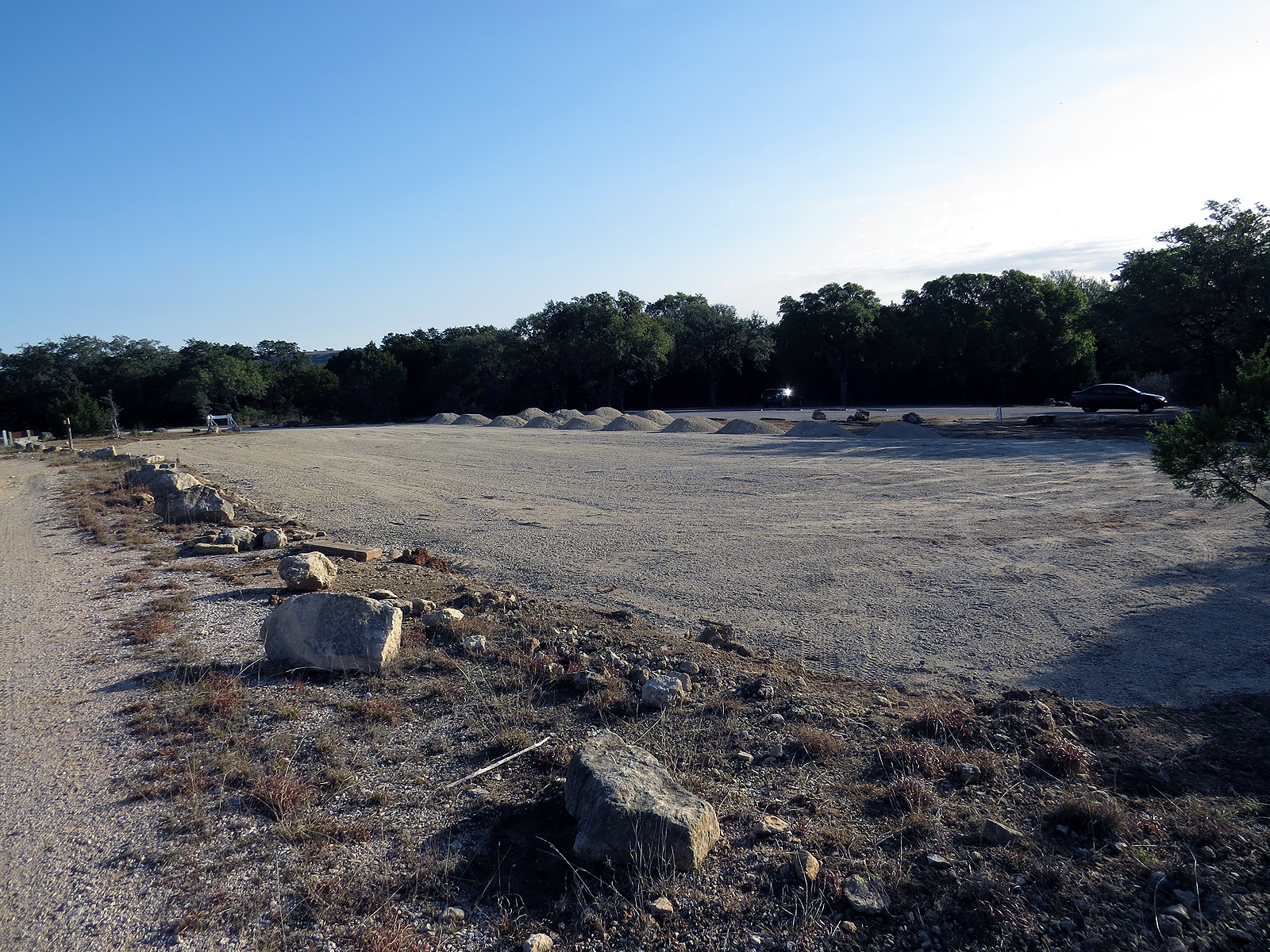
Just after leaving the burn area behind I went by the Wolf Mountain trailhead and got an unpleasant reminder that people are putting more and more pressure on this park.

Unless you've been there this photo probably doesn't mean much, but in the distance, were that car is parked, is the original parking area for the trailhead. Everything there in front of me is clearly where the park system is in the process of more than doubling the capacity of the parking lot.

Sigh - - -


With the sun just barely up when I started out, the day (Jan 26) was pretty dang cool and I left camp wearing a base-layer, two shirts, and a heavy jacket.

By the time I had worked my way out to the Juniper Ridge trail and hiked its first couple of miles things were heating up, even in the shade.

If you look close you can see that I'd already removed the jacket, crunched it up nice and small, and strapped it to the bottom of my pack. But now that wasn't enough and I needed to ditch the base-layer and one of the shirts too.

This, of course, required stripping down to skin and fortunately there was no one around, because nobody wants to see that! Even I had my eyes closed to avoid getting an unwanted glimpse of the dreaded fish-belly-white old-man-belly.


From the late 1930's until they turned the land over to the park system in the '70s most of what is now the State Park was owned by the Wheatleys and run as the Circle Bar Ranch. In 1960, perhaps because Charles Wheatley was an oil man himself, they allowed a pipeline to be laid across the southern end of the ranch.

There are actually three pipelines here now on two parallel easements, one gas and two petroleum, which the Juniper Ridge trail crosses twice and touches once.

Back in 2015, while the trail was still being developed and before any maps of it existed, I was following fresh-cut stumps and limbs along the new trail, and when that petered out, the sometimes erratic survey-tape marking it's proposed route. At the time I knew little of the trail other than it crossed the pipeline at least once because I had approached that crossing from the other side the day before.

At one point the flags led me out to the pipeline then disappeared on me. I assumed this was where the trail crossed the pipelines but could find no sign of it on the other side, the north side.

So, knowing that if all else failed I would eventually run into Windmill Road, I set off east down the pipeline to find the trail.

Good plan right?

Well you see that steep dip right there in front of me? That goes down, way down, to Butler Creek, which was running deep enough that I had to hunt up-creek for a place where I could safely cross. (If you're lost always head downstream since you have a higher chance of encountering civilization in that direction. If you are trying to get across head upstream since there will likely be less water the farther upstream you go.)

And that slope on the other side? Well that was even steeper, as in hands and knees steep. The good thing is that I found the trail I was looking for on the other side of that climb.

I don't have that problem anymore. (losing the trail) Not only have I hiked this trail several times since, it has seen more use, making it easier to spot, and now shows up on the map which clearly shows to follow the south side of the pipeline easement towards the east for a few hundred yards where the trail then plunges back into the trees again.


So it was with confidence that I continued skirting the edges of the ridges


and dropping down to cross the occasional stream, until I eventually closed the loop and plodded wearily back into camp some 12 miles later.

Tomorrow (OK, next week in blogger time) - a short hike across the river into history as this old man takes a recovery day.