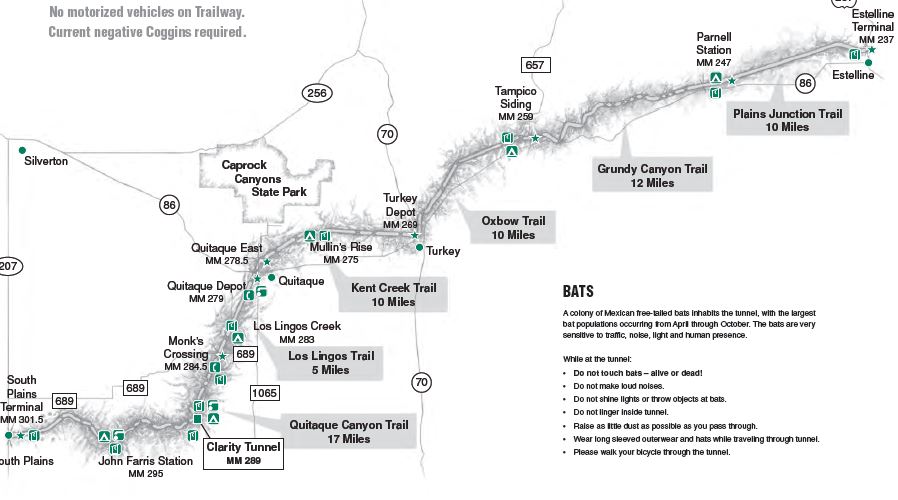
Quitique, the town just south of Caprock Canyons State Park, has one of the seven access points to the 64 mile long Caprock Canyons Trailway. (There's actually eight access points, two in Quitique, but you can only park at one of those.)

For some reason these access points are not marked very well. This is the only sign I found for the Quitique Depot access point (the one with parking) and it was about 700 feet east of the access point itself, but what's a little confusion when you're out to have some fun?
The access points are all self-pay and the daily-use fee for the Trailway is $4 per person unless you have a Texas State Parks Pass, then it's free. I bring this up because you will want to make sure you have a pen with you to fill out the permit, which is required even if you have a park pass. (I've run into more than a few people at self-pay stations searching desperately for a pen, or even a stub of pencil.)

The Trailway used to be part of the Fort Worth and Denver South Plains Railroad built in the 1920's and used until 1989.

Since then the stretch between South Plains, up on top of the Caprock Escarpment, and Estilline, down in the Red River Valley has been turned into a hike- bike - horseback trail.
Since I can't fit a horse and all the tack that goes with one into The Van, and hiking this smooth almost road-like trail (OK, smooth and road-like was an assumption on my part that wasn't entirely correct!) on foot somehow just felt wrong, getting the quad-B down off the rack seemed the way to go.
There's an elevation difference of some 1400 feet between South Plains and Estilline, and most through bikers seem to favor taking on this trail from southwest to northeast to take advantage of gravity.

But I, not being a through-biker, ignored that logic and chose to start out at the Monk's Crossing access point and ride uphill to Clarity Tunnel..
It was just shear 'luck' that not only was I going uphill, but there was also a south wind blowing right in my face at the same time. A strong south wind!
Now this is the plains, and the wind tends to not only be relentless, but also to get up some speed out here, but this was ridiculous!
Sitting way up there on top of the quad-B like a big-ass top-sail on a tall-ship it felt like the wind was doing 40 MPH, so, just like when estimating wave height while curled into a whimpering fetal ball in the bottom of a small boat, I cut that estimate in half and convinced myself that I was only facing a 20 MPH headwind as I stomped the quad-B, pedal by pedal, uphill. (Checked with the National Weather Service later and felt vindicated to find out the official winds that day topped out at 29 with gusts to 38.)

I took this shot shortly after I left the trailhead looking back the way I had come. If you could blow it up enough you would see The Van right there under the arrow.
I didn't realize then just how glad I was going to be to see The Van, even way off in the distance, when I was on my way back that afternoon!

It would have been a lot easier if I did this back in the days when I was a serious rider, back when I commuted by bike and spent 50 miles a week in the saddle without even trying and 100 mile weeks were not unusual, but that was then and this is now. Hell, now days I ride a $159 bike with a big wide Granny-butt saddle on it and all summer long I averaged a gut-busting, oh let's call it, 0 miles a week on it. . .

Not too far south of Monks Crossing is the site of Edgin Siding

The most visible remains being the foundation of the water tower.


Within sight of Edgin Siding, on private land east of the Trailway, was this semi-permanent camp anchored by a canvas wall-tent complete with chimney for a wood-burning stove. No people around today but it was clearly recently used. After all, tents like this are edging on up towards $1000 so you don't just leave one of these laying around!

Here on the plains things are not as 'flat' as people that don't live here tend to think, and this is one of some 46 bridges along the Trailway.

Among those 46 bridges is this one carrying the railroad, and now the Trailway, across Turkey Creek.

It's clearly more substantial than necessary to safely get me and the quad-B across, but it's a steep climb down to the creek and back up the other side again so I wasn't complaining!

And the prairies are not all grass and scrub either.

In fact the builders of the railroad would have been up shit-creek if it wasn't for the gravel-beds along Quitique creek!

Although I never saw another person all day out there on the Trailway, clearly it was being used by something other than humans, bikes and shod horses. I'm no expert but for my own peace of mind I decided these were cows (And not bison!) using the Trailway to get to greener pastures.

Of course cows (Not Bison!!) aren't the only critters wandering around out here. Judging by the classic 5 long toes closely coupled to a roundish foot and all 5 claws clearly showing, this was a raccoon taking advantage of nearby water.

It was surprisingly nice while it lasted, but the dead-straight, relatively flat rail-bed of the valley

eventually ran into the lower reaches of the climb up to the Caprock escarpment.
By the way, the Park Service specifically recommends against traveling the Trailway alone because sections of it are remote.
It's hard to imagine that a park that's only 100 ft wide can be 'remote' but I can personally attest that it is! Not only did I share the Trailway with absolutely no one all day, I didn't see anyone off the Trailway either. Other than that empty camp, I saw one distant cluster of lifeless looking RV's and at one point I could see the back of what looked like an equipment barn that, according to the map, must have been a good 2 miles away.
And yes, I know it's frowned on in some circles but, as is the case with about 99% of my hiking, kayaking and biking, I did the Trailway alone. That's a choice I make that I've discussed before. I do think I go reasonably well prepared and with the mindset of self-rescue if it becomes necessary. (Unlike those such as Two-sticker from the day before who set out with little more than a T-shirt on their back with the expectation that someone else will come and get them if they get into trouble. . .)

A couple miles after I started the serious climbing I came to the pit-toilet and watering station near the entrance to Clarity tunnel.
This is one of 6 spots along the Trailway where camping is allowed. ($12 per night per tent.)

Note that there are plenty of warnings posted on the web and at the access points about there being no water available along the Trailway. I'm not sure if these watering stations are seasonally maintained or if it was one of those good ideas on paper that just didn't pan out in real life. At any rate they were all dry when I was there so make sure to bring all your water with you!!

The current northern entrance to Clarity tunnel is just around the bend there, but up until a 1973 derailment inside the tunnel collapsed part of it and forced the railroad to dig their way back in to get to the trapped cars, the entrance was right about where that white sign on the left sits now. (The sign is a warning to wear long sleeves, a hat and don't disturb the bats while going through the tunnel.)

In fact there used to be two tunnels along here, but a derailment in 1968 forced the railroad to 'daylight' the Gowdy Tunnel. Daylighting is when you remove the mountain above the tunnel and open the rails up to the sky.

The bats had long since headed south when I was there,

but they had left their - ummm - let's call it their mark, there inside the tunnel. This stuff was thick and soft and worse than walking on sugar-sand!! But not wanting to risk derailing and becoming the source of yet another tunnel collapse, I chose to do the wise thing, which I admit sometimes seems like a rare phenomenon, and walked the quad-B through the tunnel.


It's a curved tunnel so I couldn't see the other end until I was a good ways through. If it was any longer I'd have been tempted to get my headlamp out, something you want to avoid when the bats are in residence!

But I made it through to the other end with no derailments, no chittering, air-born rodent attacks on my exposed neck and no icky stuff dropping on my head, though there may have been some icky stuff work it's way down into my boots. . .

This was supposed to be my turnaround point. The spot I called halfway when planning today's outing. But it's also the spot where the Trailway starts to get serious about working it's way up through the twisted canyon of Quitique Creek towards the edge of the escarpment. In other words the spot where things were starting to get interesting.
According to my map it was only another 6 curvy miles up the canyon from here to the John Farris Station. True, that's farther than the 5 miles I've covered so far just getting here to the tunnel, but how could I pass up the opportunity to check out the John Farris Station?! (I know, I know, but it's a guy thing and we can't help it. . .)

It wasn't long after making this - well, to be modest about it, brilliant - decision to push on despite the climbing grade and still relentless wind, that I came to the spot that used to be Gowdy Tunnel. It's easy to see why the engineers had initially decided to tunnel through the unstable rock rather than just cut through it.

This is one mountain that's more than willing to fall down, and some of these rockfalls are clearly recent. Oh shit!!! And here I am standing around at the bottom, ground zero for falling noggin-knockers, just to get a few photos!! (I guess my mama did raise a fool. . .)


Notice that the surface of the Trailway is more cindery and less refined now. I can tell you from personal experience that the 1"-and-fines cinder surface I was on now offered quite a bit more rolling resistance than the 1/4"-and-fines surface down there below the tunnel. In fact I'm not sure it would be wise to tackle some sections of the Trailway on a road bike with skinny, high-pressure tires.
But the grade and wind hadn't been enough to stop me, and neither was this more challenging surface.

So I kept on stomping pedal.


As I climbed the ravines got deeper


and the bridges got taller.

As I gained altitude the vegetation changed too. In some spots I was reminded of Eastern hardwood forests.


where I more or less collapsed like a dynamited building into the shade of the defunct watering station.
Eventually I recovered enough to partake of a long delayed, well deserved lunch

and check out the map.
I realized that from where I was to the head end of the canyon; to the top of the escarpment and the mecca of flatland; was only another 3.5 miles,

but then I pulled out the GPS and took a look at my track profile so far, stuck my wet finger into the air to verify there was no sign of the wind letting up (It didn't for three more days!) and came to my senses, guy thing or not.

Even with the wind at my back and gravity working for me, I sure was glad to see the tunnel coming up again because that meant I only had 5 more miles to go before reaching The Van's shelter from the relentless wind and the bliss of fossil-fuel locomotion!!
But first let me stop and dump the bat-shit out of my boots again. . .
Thanks for taking us on this journey. I'm going there in a few days to ride east from south plains.
ReplyDeleteHave a good ride! Looks like summer is backing off a bit now, just hope it doesn't back off too far. Snow already in Montana/Wyoming!
DeleteSame as other commenter, thanks for the journey! I'm heading there for a bikepacking trip, going to spend several days going from South Plains to Estelline and back. Looks like I'm going to get some cool days and cold nights, with a lot of headwind.
ReplyDeleteThose winds can be brutal!
DeleteAt least the goats-heads, of which where should be plenty this time of year, aren't as tough of hiking boots as they are on bike tires.